Webinar: Point Clouds: From Recap to Civil 3D

Vložit
- čas přidán 20. 10. 2021
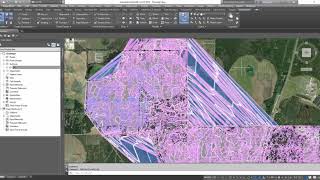
- In this session, we walk you through the steps to take with Lidar data in Civil 3D. You’ll learn more about how to use Map 3D functions to filter classified point clouds and build your surface.
Subscribe to Applied Software: / @asti
Click the bell icon so you'll know when we add a new video!
▬ Follow Applied Software ▬▬▬▬▬▬▬▬▬▬▬▬
► LinkedIn: / 35742
► Instagram: @graitec
► Website: www.asti.com
▬ Sponsored Podcast ▬▬▬▬▬▬▬▬▬▬▬▬
Bridging the Gap: bridgingthegappod.com
► Google Podcasts: podcasts.google.com/feed/aHR0...
► Apple Podcasts: apple.co/32Ka3z2
► Spotify: spoti.fi/2VE32P6
► CZcams: / @btgpod
►Instagram: @bridgingthegappod
The AEC Disruptors Podcast: theaecdisruptors.com/
▬ Strategic Partners ▬▬▬▬▬▬▬▬▬▬▬▬
GRAITEC - A global leading BIM provider graitec.com/
Applied Software, a GRAITEC company, is a full-service premier systems integrator for the AEC, MEP, fabrication, and manufacturing industries. We are on a mission to transform industries by empowering our clients and championing innovation with real-world expert consultants. With a broad range of world-class solutions, services and training, Applied has been helping clients achieve a competitive advantage since 1982. For more information, visit www.asti.com. - Věda a technologie


Lots of good info. You kinda breezed over Creating Surface from Point Cloud. Whenever I created a surface it was completely empty. After trial and error I found out I needed to change settings in the Style. Just an extra 20 second explanation of this would have saved me a lot of time.
Cool presentation !
Btw; how can we export that data in LAS format ?