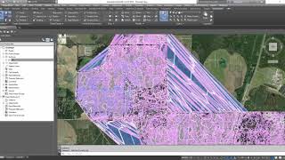
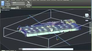
How to Clean Up / Organize Point Clouds in Autodesk ReCAP Pro

Vložit
- čas přidán 12. 04. 2018
- In this (7 min) video, I show one approach on how to quickly organize / clean up your Point Clouds in ReCAP Pro. This is accomplished using a series of Regions.
Learn more tips and tricks at civilimmersion.typepad.com


It's great that there are people like you.
Would be awesome a video showing how to bring this data to Civil 3D and to build a surface or something useful to be used as design element into Civil 3D, just like any other survey data. Thanks for this vid.
great mod, everything works, thanks
now i am in a good mood
very useful video, I am working with recap , i have some lidar point clouds data for some street in my city,i want to do safety analysis for this street for my pdh research , i just have a data but i don't know how to deal with them,and what is the latest research topic related to lidar point clouds , can you please give me some advise how to start my work. thank you in advance
I'd be interested to know the settings you used. Did you use Minimal filter, 0 decimation, … I'm looking to better understand what Recap settings provide what aspects. Thanks
Thanks for the video. My point cloud from my dronedeploy capture has the incorrect Z -value by about 1000m. Is this due to it not being geo-referenced?
would you say that the regions slows down revit once imported? I had this problem a while back never tried using regions again. Ill try again, someone also mentioned to separate the point cloud regions into diff files. Not sure. Also I had heard to export rcs instead of rcp in order to import to revit that is
Did you need to export to a unified RCP prior to doing this for the speed of exporting an RCS later ? I'm having huge problems with slowness to export RCS with my RCP full of regions.
Thanks in advance.
hi I would assume that the camera used on this Quad wasn't a Mechanical Shutter? Not good quality. I am asking because if I was going to go with this software I would hope it has more quality detail. Thanks for your time.
What about the performance? It tends to frop very much when working with regions. Is there a way to deal with this problem?
i just read your comment after I typed mine above. yes I had the same issue
How can i insert the image to recap photo??
Hi Jerry.. not sure if you provide answers through comments like this on your channel but I've been trying to troubleshoot an issue.
I've been using a DJI Mini 4 Pro to fly and capture geotagged photos autonomously with no base station and when importing into Recap Photo, even though the stitching is clean and I select the 'real world' coordinate system upon import for processing with multiple GCPs (north, easting, and elevations assigned), whenever I export to any format (xyz, PLY, PTS, etc), the X, Y, and Z end up stripped out and are defaulting to 0.
Any idea where in the process that the coordinate system is getting lost?
Thanks brother, can I get the torrent version?
Really? Your ReCap is working after creating Regions? Mine became extremely slow and in Reality unusable after creating regions.
It would take forever to clean vegetation from the total area of that scan. Seems a very very basic scan processing program.