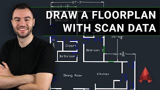
Extracting Elevations From Recap Pro to AutoCAD + PDF

Vložit
- čas přidán 27. 10. 2020
- 22 minute demo of my workflow showing how I get a portion of a scan from Recap Pro 2021 in to AutoCAD, get it facing the right way for drawing, and then plot to .PDF.
Here's the files if you want to try the AutoCAD bit yourself: drive.google.com/file/d/1Yomh... - Hudba


Hi Richy! It's Julia, a graduate from UoD. I needed this tutorial for work and was very glad when I heard very familiar voice :) Thanks for sharing your work!
Good to hear from you Julia. Hope all is going well? If there's anything else I can help with just shout. R
@@emmockladdie All good here in my corner of the world 🇫🇮😁 Thanks, really appreciate that! Take care
awesome video. many useful tricks, thank you. i have an old house with all walls being under different angles and i have scanned it a while ago but was pulling my hair to understand how to reorient to trace all the different facades in AutoCAD (am a revit person, so AutoCAD is not my friend, couldnt find reference planes to draw over etc.. this trick will do it, thank you again!)
Interesting. Love your content. Stay safe bud
Outstanding tutorial, helped me a lot, thank you, greetings from Brazil !
sem problemas, tome cuidado amigo
instaBlaster
Great Video, It is worth to see it. Thanks
Thanks for the helpful tutorial!
gracias por compartir tus conocimientos
Thanksss!!!
This is a brilliantly clear video - thank you! I was wondering if you have one on generating sections and plans from point clouds?
@@mauriceshapero7200 Hiya. Using automated tools? Found most of those to be useless. I have some vidz that show how I work from point clouds - there's no shortcuts I have found, I promise I would be using them if they were worth using.
@@emmockladdie yep, I've worked with point clouds a few times over the years and found them to be difficult every time! Is it possible to clip the point cloud in Autocad? Or is it best to do it as you do in your video - clip and export in Recap Pro? Another question I can't seem to find anything on is making a mesh from the point cloud - do you ever do this? Thank you again.
@@mauriceshapero7200 hi, clipping is easy in autocad - file must be .RCS though.
Can be tempting to copy the cloud and have lots of clips but then you risk a nasty crash. A couple of clips is ok ... Don't risk more.
Recap pro is offering meshing again as a service - they email you when it's ready. Generates a crazy amount of triangles, very poor smoothness. I will dig out a couple of videos and post links as a new reply to you.
Making a model of a maternity suite at a local hospital - these are videos from a class that aren't public on CZcams - just because they are a bit rougher. Hope these help.
czcams.com/video/_DtqEog9t2o/video.html
czcams.com/video/6LAs7AVk_-E/video.html
czcams.com/video/lyRARb3Qk8o/video.html
czcams.com/video/vFRMsfgn6fM/video.html
@@emmockladdie Thank you so much - really really helpful. These are great.
Great video, thanks for taking the time to make it! Was wondering though, after you export the PDF do you take the PDF into AutoCad and trace it? If so how do you take the PDF into AutoCad? I usually trace the pointcloud in AutoCad but think your method might be better as the PDF is very clear and detailed, also less stress on pc. Thankyou
You raise a good point there. I would generally deal with each elevation RCS file separately and just get stuck in in AutoCAD and trace the point cloud ( here's me tracing: czcams.com/video/xPrZB1REo98/video.html ). I find PDFs in AutoCAD aren't the smoothest. Import the PDF into PhotoShop and save it as a big JPEG. Then import the JPEG in to AutoCAD instead. Best regards. Rich.
Hey man great work i just wanted to know that can i draw the dimension line in this model if it is then please tell me how! If possible please reply ❤
Hi. If you try to put in a dimension it will need scaled up because point clouds are life size.
Command DIMSCALE enter 200 enter.
Then try drawing your dimension - the number should be readable. If that was not your question get back to me.
How did you get the buildings? From google earth? Thanks
It's a laser scan.
Thank you very interesting, but i have a problem, my pdf file comes out not really detailed, can you please help me ? thank's a lot !
Print big A1 or A0. You have to adjust the cloud point size accordingly or there will be too much white space between dots.
@@emmockladdie thank you, I found out my error, i was scaling the cloud, i tried again without any scaling and the pdf is much better, thank you very much !
You can just make a region and export that region without having to delete all the extra points.
I'll give that a go, thanks