River Landforms - Waterfalls, Meanders, Oxbow Lakes, Levees & More | AQA GCSE 9-1 Geography

Vložit
- čas přidán 22. 05. 2024
- What are the erosional landforms of rivers? How are waterfalls and gorges formed? What are v-shaped valleys and interlocking spurs? What are the depositional landforms of rivers? How are meanders and oxbow lakes formed? What are floodplains and levees? What are estuaries?
This is the thirty-fourth video for the AQA GCSE 9-1 Geography course, and the first video of the Physical Landscapes topic.
The Physical Landscapes Playlist:
» • Physical Landscapes | ...
Follow me on all platforms:
» linktr.ee/keducate
Do you have a video suggestion?
» forms.gle/gxc3xHQ1b1wUeANT9
Video Script:
Various river landforms are found along the three courses of rivers, forming due to erosion, deposition or both.
Erosion is most prevalent in the upper course of the river and as a result this is where erosional landforms are mostly found.
Vertical erosion is responsible for the formation of v-shaped valleys. Hydraulic action and abrasion erode the river downwards, leaving the channel with very steep, unsupported sides. These are worn away by weathering and when they collapse a V-shape is left behind.
When the river meets more resistant rock types, it bends around them and cuts through weaker rock instead. This forms interlocking spurs.
One of the most recognisable river landforms is the waterfall. They form where the river flows over different bands of rock. Soft rocks are eroded easier, creating a waterfall and undercutting the harder rock. This overhanging harder rock eventually falls to the base of the waterfall in the plunge pool, which is created by abrasion and hydraulic action. These hard rocks can swirl around in the plunge pool causing even more erosion. Over time, this process is repeated and the waterfall retreats, leaving behind a narrow and steep-sided valley called a gorge.
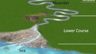
Deposition and erosion work together to form the next two landforms: meanders and oxbow lakes. These are found lower in the course of the river.
Meanders are bends in a river. The outside bend has more erosional power as the water is deepest here, meaning it has the highest velocity. This forms river cliffs. The inside bend is shallower and has lower velocity, meaning deposition occurs. This forms slip-off slopes. Over time meanders migrate across the valley floor and they can erode towards each other. This gradually narrows the piece of land between the meander bends, called the neck. Eventually this is broken through to form a new straighter river channel, typically during a flood. Deposition cuts off the previous meander bend, leaving behind an oxbow lake.
There are also a few depositional landforms.
Floodplains are wide, flat areas of land on either side of the river found in the middle and lower courses. They are made of silt that is deposited when a river floods. This silt, known as alluvium, is very fertile which is why floodplains are often used for farming. Floodplains are widened by lateral erosion from meanders migrating across the river valley.
Levees are found in the lower course of a river. When rivers flood, sediment is deposited across the floodplain. The largest material is deposited on the banks of the river. Over time, this sediment builds up creating a ridge on either side of the river - this is known as a levee.
And finally, estuaries are found where rivers meet the sea. As the river approaches the sea, it widens and slows down. The volume of water is affected by the tide and when it is lower, the river deposits sediment to form mudflats, which develop into salt marshes over time. These are important habitats for wildlife.
--
GCSE Geography
14/05/2023
Keducate