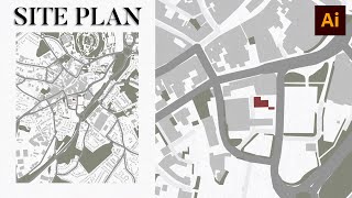
Create Custom Google Maps (Complete) in Adobe Illustrator & Snazzy Maps (2021)

Vložit
- čas přidán 5. 07. 2024
- An overview that how you can create a Custom Google Map for your website, apps and social media. I have used a platform snazzymaps.com/ for this purpose.
00:49 Set a Map Style in SnazzyMaps
05:20 Saved the Image in 3x Dimensions
06:50 Bring it to Adobe Illustrator
06:55 Vectorize the Image
11:00 Add the Labels
Facebook Group: / ahmedqayyum
Instagram: / ahmedqayyum32
Linkedin: / ahmedqayyum32
Twitter: / ahmedqayyum32
Thanks for reading the description.
![How to write Quran text in Adobe Illustrator & Indesign [95% Working]](http://i.ytimg.com/vi/rqRYcUyvsqo/mqdefault.jpg)
![How to write Quran text in Adobe Illustrator & Indesign [95% Working]](/img/tr.png)


Keep up the good work man! This just made making site plans way easier.
Thanks Manav.
Do share the results with me? Or suggest what else should I cover for custom maps? Which is missing in this video.
This is the best free software Ive seen. Respect.
Thank you man!
Love from India :)
Thanks Aayush for the words!
Thank you for sharing! This is really helpful! :D
Thanks @Stanley. What map you are going to create? Can you share a little?
Thank you so much!!! I have to credit you for my finals project! Thank youu!!
Thanks for the comment Yoyo. What was your project?
This was so helpful!! Thank you
Glad it was helpful!
you saved my life, thanks you so much
Glad it helped!
This was so helpful !💖✨️
Glad it was helpful!
Your video has been a huge help thank you very much
You're welcome!
This was very helpful. Thanks for sharing 😁
You are so welcome!
Many Thanks for the helpful tutorial. Bless you
Glad it was helpful!
best free software Ive seen. Thanks for your video
Wow, thanks!
Very Helpful Thanks!
Glad it helped!
Thank you so much, it’s so useful video❤
Great 👍 My pleasure
THANK YOU! THANK YOU MY GOOD MAN!
That makes me happy everytime when someone like you finds the content helpful. Really appreciate for considering my video in your case. Thanks Katherine!
thanks, love it
Glad you like it!
Woow thank you its very helpful!
Thanks Renee if it was helpful.
Thank you was helpful
So nice to hear ☺️
Thank u so much!!
You're welcome!
thanks bro ur vid help me..
You are welcome
Thank you so much ❤
You're welcome 😊
thank you!!
Glad to know if you find this video useful.
Thank You very very ^^
Thanks for the appreciation.
Thank you! Snazzy Maps is cool, but also a bit difficult to handle
Yeah. But can be very helpful.
What shortcut did you type on your computer in removing some section? Thank you! Btw great vid.
I didn't use any shortcut. It's just the select and pressing the delete a button from the keyboard. If you still have confusion, then please mention! I would love to assist you through it.
@@ahmedqayyum Thank youu!!
Thx somuch bro
Thanks. Cheers!
thnkyou for this
Thanks Ketchup!
thanks for sharing
Thanks for watching! ❤️
Thank you
Thanks @Florin
you are a saviour thanks for introducing the tools
Thanks man. Where you are going to use this information?
@@ahmedqayyum Customized designed map for printing the flyers
@@shrinikannan3463 Very nice.
Very Informative ❣️❣️
❤
Thank u very much
You are most welcome
More adobe illustrators tutorial for beginners please 😭😭😭
windows system.. lets you focus on what your using it for only.... making soft. Enjoy the journey my new friend!!
Welcome aboard!
Thank you. it is possible to import a map through a embedded link from mymaps google?
Into Snazzymaps?
Thank you very much!! An important question, is the map legal for use on the website? any copyright from google? thanks!
You can find the details at www.google.com/intl/en-GB_ALL/permissions/geoguidelines/
thanks
Shukrya Naseer Iqbal Sahab!
thanks bro
Thanks Musab.
nice
Thanks @Aayush. Where did you implement this knowledge?
you the best!
Thanks if it helped you.
Ahmed, how are you? I need to create and download a city mpa, like Rome/Italy for example, but with a good zoom level showing the small streets. If I zoom in the map will be reduced and I cannot have the whole city. What can I do? The other option is downloading it by pieces and join them but this is not the best idea because there is a 10 maps per day limit. Regards, Florin
Great question @Florin. Let me check that how we can achieve it.
@Florin Where do you want to use that image? Maybe we can find better solutions.
@@ahmedqayyum Good morning Ahmed. I have a great client and he is selling maps posters and is asking me for this kind of linear style, you know, no ground etc but only the lines of the big, mid and small streets, black and white. The problem is this: if I zoom in to achieve the small streets view, not only the main ones, this zoom is reducing the general area. So, I need to catch the whole city zone with details but zooming the area will be smaller. Thank you.
I understood. I need to check for the solutions.
@@ahmedqayyum Thank you.
Iwas wondering, if I want to make a map that has a scale 1:200. And wish to add a building that has an area 20x30 meters. How can I go about it ?
In Illustrator, you can change the unit, and then you can create anything with respect to that unit.
ok I ll google the steps
@@ahmedqayyum
Then how to add some features on it?? Like buildings and save as API? Not just image.
You can turn-on the building from the settings panel.
Salamun Alaikum sir..
Thank you for this video..helped me alot.
I have some queries about presentation and stuff. Where do I contact you?
Send an email at ahmedqayyum32@gmail.com
Or send a message at my Instagram or Linkedin. Links are mentioned inside the description.
hello ahmed how are you?
i want to creat a map for my city it is for real estate pourpuse .
i want it basik squers with numbers of each prouperty in these squers would you help me please?
I can only guide on how to create.
Pehle Dongi Gound kesi thi. Or Ab m Dekh kr to preshan ho gya.
😂
Gd Ahmed bhai
Mutee ur rahman
Shukrya Mutee ur Rehman. 😊
very nice where is next part
There is no next part. What do you want to explore more?
This is like GTA style maps. How can I apply markers on this map for example like GTA? Hospital, Port, Airport, food etc..?
That can be easily done in Illustrator
10:18 new core memory
One question, how can I visualize real time movement in that map?
In this specific case we can't. Because we are processing an image to showcase.
Bro I also make map with help of google, i am in polio program many streets missed in google maps we personally visit street and than make on illustartor, by pen.tool so its easywasy u told but many small.streets missed in google map so it failed in my program.☺
What do you mean by 'You failed in the program'?
@@ahmedqayyum bro this google map failed in polio program, as google didnt show all streets, as you know polio program is door to door and polio team never missed a single house/baithak and any door so google map didnt show all streets there are many links which google missed so that why i personlay visited that area and than make it on our map which google missed.
@@ahmedqayyum if u have whatsap number or email send I will send my work to you, as We work street to street and House to house and also mention with colour
@@simpleman4176 Very nice.
How do I get rid of the building outlines?
You can do this inside snazzymaps build mode.
in!
Do you like the content? Where did you apply the method?
boss aap nay konsa map use kia ??
I generated a custom map using Snazzy Maps, and then edited it further in Adobe Illustrator.
how to add alocation some one send me to customise it
Goto that location. Customize map and then take a screenshot. Bring it Illustrator or any other design to further customize the map.
Is this available worldwide?
Yeah. Worldwide
AOA sir Mera aik question ha related Fiverr
Ma business cards ka upar aik gig banaana chata hu to us ka liya ma na keywords research Kiya ha
Par haar keywords par 3000+ services ha
To Kya ye low competition keyword ha ya nahi
Agar nahi to Kia karo phir ma
Business Card ma koe specific business ko target krlein. Jesay, you can offer business card design services for Accounting/Finance related people, etc.
Aisay apko competition kam milay gaa
@@ahmedqayyum nicee thank you sir
can I edit the size?
Can you please explain this a little? Size of what and where?
@@ahmedqayyum in the website before I download it. I need a rectangle for a website hero larger than 1000 px. Or that should be done in illustrator?
@@ArtandKitchen_ Do it from Illustrator. Because the website provides limited size. We can't go beyond. But in Illustrator, you can create a dimension of your choice.
Snazzy Maps just sucks!! Your video helps, it's just the implementation on the Snazzy Maps website is horrible.
Yes. Not very easy to understand at first
i am from 2024 like the comment if you too
👍
IS IT PAID OR FREE?
It's free. Adobe Illustrator is paid.
Thankyou for sharing 😊