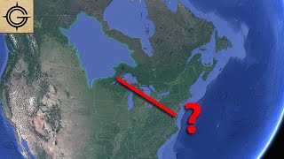
Why is there a Sea in America on Old Maps?

Vložit
- čas přidán 6. 07. 2022
- Maps from the age of discovery are filled with some pretty interesting geography. They had a mass that kept the world from tipping over, the north pole had a giant magnetic rock in the center, there was even land populated by giants.
But what I’m about to show you is one of my favorite examples of weird geography on old maps.
Social Media
------------------------
Map Shop - zacksmapshop.com/
Instagram - / thegeographygeek
Patreon - / geographygeek
Email Newsletter - eepurl.com/hSeKpj
Sources
-----------
www.biography.com/explorer/gi...
exploration.marinersmuseum.or...
blog.ncmaps.org/sea-of-verrazz...
RareMaps.com Sources
------------
1529 (but circa 1890) [Early Photographic Facsimile in 24-Sheet of the Verrazano World Map] - tinyurl.com/yhx9d9xn
Sebastian Munster 1544 Map - tinyurl.com/48acuk27


Thank you RareMaps.com for supporting another video! Their maps and descriptions are a huge part of the research and visuals that go in these videos. You can purchase your own Verrazano map from their website. - RareMaps.com/
After the pole shift (aka the "ice age") some 12,000 to 13,000 years ago, the North American ice sheet would likely have taken decades to melt, flooding some regions of the continent and may have drained into the Gulf of Mexico, following a similar path to the present Missouri and Mississippi Rivers. Perhaps ocean levels remained higher for a long period of time so that midwest regions remained flooded in the interior.
There's actually quite a lot of historical information supporting the existence of a race of very tall natives (well over 6ft) in Southern Patagonia..
@@edwardfletcher7790 for sure. This topic is actually my next video.
@@GeographyGeek That's awesome 👍😆
Can't wait to watch it !
PS: Thanks for that excellent series on Australia 👍
@@edwardfletcher7790 no problem! I’m happy you liked them!
Little did these explorers know there kind of was an inland sea, the problem was it was the Great Lakes which swallowed up ships.
Misplaced Hudson Bay.
@@homoerectus744 It looks like someone thought Lake Michigan, Lake Superior, and Hudson Bay all linked up to each other.
@@Eibarwoman true,I made my assumption in addition to what is indicated.because from my observations of the old maps,and accuracy peninsulas are islands,continents are merged where bodies of water are...minor shit like that.
Those dead explorer will be happy to know they're arch nemesis is currently drying out
I remember one French explorer thought that the Wisconsin side of Lake Michigan was the coast of China (he must have missed the fact that the Pacific Ocean isn't freshwater) and went ashore near the site of present day Green Bay wearing a set of Chinese robes he had brought with him! I wonder what the local natives thought of his outfit.
I love CZcams channels that educate. Most people today couldn't read a map to save their life and GPS doesn't always work
Oooooohhhh k grandma
On the Island of Montreal (Canada), there is a bourough named « Lachine » as in « The China » It has been named because it was on the shore of the St.Lawrence River where they thought that the Great Lakes were the passage to Asia.
That's interesting because there is also a Lachine in Michigan just to the West of Alpena in the Northeastern corner of the lower penninsula.
@@falconquest2068 As they were expending west, they were still looking for the now-called Pacific Ocean. The expansion of New France in the Mid-West (named « les Pays-d’en-Haut » meaning « The Upper Countries ») is quite interesting.
@@Christian_Martel Yes. I guess what they didn't know is that there was a whole continent to the West before they ever came to the Pacific ocean which is huge compared to the Atlantic. Such is exploration I suppose.
Did anyone else notice that this map shows what they called Iucatana (yucatan) off the west coast of Cuba ?
Right about where they found sunken ruins.
Yucatan Peninsula has a ton of history with Native Americans and Spanish explorers. Also the location of the very famous meteor that wiped out a ton of life. Very historical sight in my opinion
California used to be an island
@@kevinconnelly365 and parts of it one day will be again.
Yes but they also show Florida and there are billions of dollars of sunken ships waiting to be found also. So not surprised.
@@roberthouston9657 technically parts of it already are
The Great Lakes are basically a sea, they are bigger than a fair number of states and all joined together. An early explorer with no point of reference could easily stumble across them and assume they are something akin to the Black Sea or the Baltic.
An equally weird thing about early North America maps is how Florida is accurately presented on dozens of maps made decades before anyone was recorded of having mapped it or even circumnavigating it.
Why are the Panama and suezcanal already there?
@@drmartin5062the Suez and Panama were built thousands of years ago by black African kings.
@@adamplentl5588, wasn’t everything?
Spanish had to map every place near their conquered lands in case treasure ships were blown off course
@@roberhatube2366 it was actually so they could keep track of which cultures they had already r*ped into nonexistence and which ones they still had to get to.
Kansas used to have a great inland salt sea. There is a giant fossil on the wall in KSU student union. We even have sea gulls that still live in western Kansas. Crazy they'd still be there.
Not just Kansas, the whole middle of North America used to be an ocean! Millions of years ago of course.
@@MerkhVision Oh, yes, that part of the land was covered by sea waters. Salt flats are the proof, as well as the sands on surface. The last time when it was partially covered by water was not so far in time, approx about 11500 years ago. Of course some fossils are from millions of years ago, but there are also recent remains (please consider the mammoths and other mammals).
I was amazed to see so many seagulls in Colorado. I lived there for about 10 years having come from Florida. I assumed they got there haphazardly via air currents, but now your comment has me wondering if they could simply be descendants of a more ancient population of gulls.
@@robertomagnani8091 If something alive was buried by mud and dirt moved by water how can anyone tell that the animal bones are millions of years old? You are believing a made up story.
@@MrLaughingcorpse Here and there sometimes someone finds fossils of millions of years old. Those are petrified. Other remnants are relatively recent, about 11500 - 12000 years old, and are not petrified. These had it's origin in times of the last great flood. But some people confuse the two types of fossils.
My cousin just found a huge fossilized shark tooth sticking out of a clay bank behind his shop, in a suburb of Baton Rouge. He thought it was a big spear at first, and he started digging it out & found that it was a very large, pointed tooth (looks just like today's shark tooth but over 6" long & about 6" wide at the base). I'm hoping he'll get LSU to evaluate his find & maybe see what else is there. Seems there must've been some type of ocean or inland sea there...
🤘👍
Not an inland sea. Just a different coastline. Land and ocean are in constant motion over time scales we can't fathom. Isostatic rebound and glaciation cycles drive the change over thousands of years
Yea Louisiana would be the first state to disapear if the oceans rise !
Thats really cool!
@@chrism4008 ikr! I've just seen pictures, I want to hold it haha!
The rest of the Piri Reis map has a lot of the US under water too. The reason we still find seashells when digging out foundations in Plano, TX.
I just found your channel, im very excited to binge all of your videos!😊 this was an awesome one!
I’m happy you found my channel! I appreciate it!
"Killed and eaten by the natives." uttered in the most casual manner.
I like how they decided to call the new found land, New Foundland. “Are you sure that’s the name you choose? I mean, it is new, we found it, and it is indeed land. You can call it anything really.”
I'm from Newfoundland, and I love this comment.
Thats literally how everything is named..lol animals land etc 🤣 you find it you name it
I think it was because no one had claimed it. Settled it. Too far. Too wild.
Considering how lethal the outer banks is to ships and how many shipwrecks there are there I am genuinely surprised they sailed through it with their heads up their ass and came out alive
🤣🤣
I grew up in Ohio and practically every rock has fossilized ocean life in them.
From the great flood
That's fascinating. What parts of Ohio did you find them in? I just want to look up the altitudes. I grew up in the Rockies and there whole ancient shorelines if you dug deep enough. Interesting shellfish fossils I found there on multiple mountain ranges were apparently oceanic as well.
@@goofballbiscuits3647 I'm from Youngstown. I helped my father alot with the garden and flowerbeds. It was so common that almost every rock was a fossil of something from the ocean that I stopped paying attention to it.
Ohio is Indian land! The original indigenous people of this land... My father owned a house made by our Indian ancestors! In Cleveland Ohio...🐢🏝🪶🏹🪓
@@brownfeather865 it's always amazing to me that I walked on the same trails made by the Ohio Indians. We found alot of arrowheads in the 70s and turned them in to the state park for the museum. Ohio history is very interesting, the Indian culture was taught to us in school.
holy crap didn’t realize this wasn’t a video with a million views. great content.
I appreciate it!
Yeah really. Surprising when i see the comment not that much. Thanks for the video bro, I really liked this kinda topic.
@@sinistercat7207 no problem! Thanks for watching!
Now it has over 1M views 😂
America is anicent Egypt aka Atlantis
Absolutely. I hope I’m outta here before they “sink” it again. Like the phoenix, they want to build the true NWO out of the ashes of America and probably the Middle East too.
What????
I would've thought that it was Hudson Bay myself.
My fave part of this map is at 1:45 where Britain looks like a mere tiny atoll off the coast of Germany.
A lot of the old maps are like this it's amusing, I remember seeing one developed by someone from England around the 16th century & the isle of Britain looked about half the size of Europe..
I love how the reports go from “eaten by cannibals” to “oh yeah, you mean pirate McGee?”
It's almost memetic: Epstein didn't eat himself.
Great channel, subscribed, looking forward to more great videos, thanks.
Cool video. The first of yours I've seen. I'm sure you have had a video of this, since you specialize in it, but I have seen old maps depicting California as an island. Makes you wonder if Lake Lahonton was not as far back as we have been told. I know someone who was told by a local Native American that his great grandfather was told by his great grandfather he took a canoe from near Lovelock, NV to near Pyramid Lake, NV and it was all water with mountain tops (now) as Islands. In that area today you can still see ancient shorelines on the sides of mountains.
Cowboy, that is a great story. There is not any argument that can be used to dismiss this story. Furthermore, I bet that the sands that can be found in deserts are from sea origin, as well as the salt left on surface. Oh, yes, it was all covered by water, sea water.
If that rendering of a giant is located in South America, they were spot on. The huge Paracus skulls are proof that giants once lived there. (The enormous, non human skills are found all over S. America, but most prevalent in Paracus, Peru.)
Still would love to know why they cover up giants. To cover up the truth of the Bible?
These maps are so beautiful and detailed. It's art without a doubt. Amazing 😍
And Untruthfully Gentile!! Where are the TAmeriKaans???🥇🥶🫠🫠🫠🫠🫠
What I love is that he still managed to get Texas on there before the concept of Texas even existed.
It's crazy because it looks like they even had a border between Mexico and the U.S way before it was actually created
There's a large bridge connecting Brooklyn to Staten Island, named after him.
I don’t believe you. I think that you are just imagining things. Verrazano Bridge, sure, whatever. Nice try.
@@00leaveralone Clearly just lies to cover up for Big Bridge.
I live on the INNER Banks of the Pamlico Sound. My husband and I fished it commercial. It's understandable that he made that mistake.
Maybe it was all frozen then? Ancient apocalypse has given a lot of cool information to consider.
Thanks for the info💙
Maybe Verizanno perished in the Bermuda triangle (just kidding)
im glad to know you were joking
It is rumored he was wearing Bermuda shorts when he died.
I used to see a doctor who had a couple dozen original, museum-quality 15th, 16th, and 17th century maps on the walls of his waiting room.
He said I was not the only one who came early to appointments. In fact, he said, he rarely had a late patient.
Why didn't you steal them ?
@Sporecat Insectivore they might be valuable
@Sporecat Insectivore nevermind, I guess you just don't like making money.
It is amazing that they got it as accurate as they did really, considering they had no idea where anything was, or even probably the actual size of the planet, or anything on it.
🤣
the size of the earth has been known since ancient greece, lol
Actually the side of the Earth has been known to a high degree of accuracy for well over 2000 years.
@@zackakai5173 Aah, well that would help to explain why the old maps are put together as well as they are, even though there are a bunch of things that are not exact. They did have an idea though how it all came together lol.
Algorithms know me to well and now you sir have a new follower!!! Awesome content!!
I appreciate it! You’re in the right place
i see from the evil demonic fallen angels quartum computer !!!
Once you realize that Giants were the Viking people or cultures similar to them the more it makes sense. That they do exist.
I would assume he followed the left bank and the lakes were so massive he assumed it was a sea.
Also, why do certain old maps show North America as having many large densely populated cities? Particularly in California region, mississippi valley and southeast and northeast.
Could be references to the Pueblo city states.
Another possibility is that was where they guessed where the "Kingdom of El Dorado" was
Perhaps this is Hudson Bay and James Bay up in Northern Ontario Canada. Looks a lot more like the Bays then it does a Great Lake. BTW I live in James Bay :)
Agreed. I see this as Hudson's Bay. The rest of the sizing is off so why not Hudson's Bay.
Why is Antarctica a Jungle on old maps from the 1400s???
Did anyone else notice the Appalachian mountains are going east to west instead of north south like we know today...jw and above the mountains showed 7 hills with trees.. could be Cincinnati jus a thought
What would make you say cincinnati
Well, right around the turn of the century, somewhere in the late 1700's or early 1800's the Appalachian mountain range did a 90 degree spin move (counterclockwise) to take the form we all know and love today. This is what formed the Appalachian Trail and began the rich history of folk tales throughout the area. They say the folk tales often resemble the ones told in Ireland and England by the folks that settled Appalachia from there
@@michaelwerkov3438 Cincinnati is known as the city of 7 hills
0:14 land inhabited by giants you say I'd love to hear more about that! Every thing I Google is just fictional stories or of course, myth.
I sony understand the writing on that still but it sure is interesting
if i recall correctly, the people of Patagonia were believed to be giants by European explorers, because on average the Patagonians were like a foot taller than the Europeans.
though considering the average height for Europeans at the time was like 5'3", that isn't saying much.
Maps are awesome!
if it wasnt for me scrolling down, i would've assumed this channel had about 600K subscribers and that this video would have 1.5 million views. Great editing!
I appreciate it!
Wow me too
I trust these old maps FAR MORE than new ones
There is also a bridge named after Verazano in NY. I live in WV and my daughter found fossilized shells on top of a hillside at my in-law's house.
Back then the maps were depicted how they were explored not very accurate but as close as they could draw them while on a ship or when they docked to explore inland.
0:35 - just glancing on this map on thumbnail i genuinely thought this is map of Lands Between from Elden Ring. I clicked thinking is some ELden Ring content...lol.
Great and interestign video non the less :D
Clicked from wrong reasons but found cool video all the same XD
I remember reading a much less detailed account of this "discovery" in a book about the Age of Exploration. I was only about 9 years old at the time I read the account, and I laughed so hard at how silly it was that an explorer had mistaken Pamlico Sound for the Pacific Ocean.
Subbed!
I appreciate it!
Thanks!
I LOVE OLD MAPS😍😍😍😍🥰
I love old maps! I wish I could afford to collect them! Did you know the uk 🇬🇧 is upside down on modern maps?? Lol 😂 I think that’s crazy
What??
Quick Q: What is the video you mentioned at 0:45 about the inland sea in North America? I couldn't find it on your channel via simple searches.
Simply Amazing, it is interesting what our predecessors saw/experienced and believed.
I wish that I lived in the time before technically and all of this darn fangled "stuff" that we have these days.
I Have Always Loved Old Maps!!!! ❤️
I wish I could get hard copies of these many-many-many of these old maps.
These are true Treasures to me.
Thank You, So Very Much for this Video!
I love maps , I always have, probably because I love traveling
I’ve been to a lot of places in the world and believe it or not i’ve actually been inside of the labyrinth on the island of Crete
Well I actually found some old maps with it on them … it’s just amazing the things we think may be myth that are true/real , & some of these old maps can prove that
Must be nice to travel anywhere you want
If you look at the Chronicles and writings of Magellan you will find that he spent several weeks restocking his ships on the Southeast coast of South America where he met with a couple the man was 13 ft tall and the woman was about 9 ft tall. Yes there were giants in South America at that time along with Giants on Easter Island when it was first found. But they had left there by the time they made it back to the island and when they asked the rapinui where they had gone they said they flew up in the air.
And up until at least the mid 1700s the English were traveling from England to the Pacific Ocean by using the Northwest Passage which eventually froze over by the 1770s. The route was Kept Secret because it was a military secret but we know this is true because ships that would leave England would go to the Pacific Ocean and be back before they could ever make the trip below South America. They even describe animals that only exist in the Northwest United States.
Cuckoo
🤔
Yup the giants are here!
🤣🤣🤣
Hudson bay just designed in the wrong place since the whole continent wasnt discovered
That would be the great lakes, The Mississippi river And a wild misunderstanding of the actual layout of North America.
Because there was a SEA. The Great basin of the western US was once Lake Bonneville, which drained out leaving the remnant "The Great Salt Lake".
Lake Bonneville predates these explorers by well over 10,000 years. That quite anachronistic.
Theres a sea in America in new maps too. Called the great lakes.
Usually folks pronounce Newfoundland wrong in one way per video, you get extra points for managing to pronounce it wrong in two distinct ways in a single video.
When he sailed into New York Bay, didn't he hang around a build a bridge? The Verrazano Narrows Bridge.
Yeah, It took him a long time cause he had to train his native work force into their new skilled trades as bridge builders. He also started the first workers unions in New York
@@chrism4008 That's right, I forgot it was Iron workers Local 1. But hey you know what they say, Teach a man to fish
There was a Native lore about the great body of water separating West and East U.S. before the White man. An author published a book about it in the late 70's It porported that even the James Bay Hudson Bay was joined to Superior and Michigan therefore superflooded the Mississsippi Basin all the way to the Gulf. The question begs would Europeans know if there were a major Tektonic event in North America 1000 yrs ago?
Oh, yes, that event left remains, but these are probably from 11500 years ago.
In my opinion that inLand sea in that map, could be the Hudson Bay or the straight between Canada and Denmark
That darned pamlico sound will get you every time 😂
Clearly it's because the terrain was completely different at that point in time. We know that California used to be an island, and no longer is due to all the dams that have been built. We also know glacification and how that half of the United States were frozen in ice sheets.
I can’t tell if you’re being sarcastic lol
@@GeographyGeek serious. Rare maps is good, David Ramsey site is good as well. Endless hours of research on this topic has shown just how different the landscape really was.
Theoretical geography was the norm at the time. The flow of information was not perfect either. Imagine the childhood game of telephone. Every part of an old map should not be taken literally. You’ll find that many from the same years also contradict each other. Not all maps from this time period show this inland sea. There is a lot of context behind each maps that needs to be researched as well. Maps are not a standalone artifact.
@@GeographyGeek I do agree with you on some aspects for sure. Yes indeed, our chronology is completely misconstrued, and one only has to look into some of fomenkos work to get a comprehension of how messed up everything really is. But some of the maps are not taken literally, as they should be.
@@tlatoanimachi It’s Fomenko that’s totally messed up.
Wait a minute! You mean there isn't a land populated by giants?
We killed the giants and ground their bones into concrete mix.
i knew it )
there is a giant up on a mountain here in north east pa)
Its amazing they looked as close to accurate as they did
North Carolina was So overflowed at the Time I can see how they thought that would be a route , very interesting.
Would be reasonable to say that sea represents the Great Lakes or the Atlantic
The magnetic "rock" in the middle of the north pole is God's last tree, you know the trees that the fallen angels cut down, and it is magnetic. That's why all compasses point there. And earth is flat with heights and dimensions.
I remember these old maps in school
1896, Lé Plongeon, author of Queen Móo and the Egyptian Sphinx in Yucatan area of South America. While he was excavating he found the story of both North and South America - once a ONE GREAT CONTINENT but flooded in a worldwide event...
As flood waters dissipated, the land between the two - off the South Coast and the Gulf - never reemerged. The water had inundated near all North America but as it receded, California was an Island and the Sea had created several lakes (now the Great Lakes). Queen Móo had lost her husbsnd and she built the "Egyptian Sphinx" in his honor - in South America (pictures in his book). She left So. America as soon as the Atlantic became passable again; she returned to her Kin in Egypt where the Sphinx was built in her honor - it was HER FACE that was removed.
Page 146 - "The country of the hills of mud, the land of Mu was sacrificed: being twice upheaved it suddenly disappeared during the night, the basin being continually shaken by volcanic forces. Being confined, these caused the land to sink and to rise several times and in various places. At last the surface gave way and ten countries were torn asunder and scattered. Unable to stand the force of the convulsions, they sank with their 64,000,000 of inhabitants 8060 years before the writing of this book."
Appears in 37 books from 1890-2007
For the rest of the story - download his book free in PDF.
I have a theory that the current maps are greatly distorted to keep things in place for a nefarious system -held together by our mere imagination. Using the Great Lakes as a resivior to fitter off fresh water to underground tunnels located between the western coast of Lake Superior and the Canadian Shield. The Great Lakes is actually the sea of asov, south of Russia- north of Ukraine.
This must be targeted to anyone not Canadian. We all know about The Hudson Bay. Its kinda big.
You just started the video didn’t you? lol
@@GeographyGeek Na, I got about half way before my brain translated it into bla bla bla.
Dude, stop embarrassing yourself
Lake Agassiz was a huge lake that is on old maps. (In the area of the water of your video. )
Geese!! Thanks!!!❤
Wishful thinking. They wanted it to be easy to sail west from Europe to Asia.
lol why didnt they just check google maps to map out the geography
fr tho
google maps didnt exist back then. They should have listened to NASA, stupid!
very funny joke man
Why didn't Magellan use a plane
Because back then, all they had was MapQuest.
As for Magellan, obviously they didn't airports in unexplored places. Where would he land with no runway?
I grew up swimming in the pemblico sound. Andy Griffith would call the cops on me when I drifted into his property. I had no idea I was boogie boarding in the American sea.
"Forced to SEE them get eaten" because they were out of gun shot range? "My what big eyes you have"
Did you ever receive my email?
Yes
These old maps were used for navigation so they had to be accurate! A seasoned Seaman would know the difference between an outer bank and a sea! Obviously there was an ocean exactly, where, he said there was an ocean, just as there was a ocean between the island of California and the mainland of America. The earth, its lands and oceans do are not fixed features, they move around! You should be asking bigger questions...
I hope you’re being sarcastic
@@TheWeekendWarrior490 how sad
@@GeographyGeek I am not being sarcastic, everyone has been lied to about all things! The old maps were accurate prior to the earth cataclysms of the near past (last 250-350 years), start with the Mud Floods, orphan trains, look at the old buildings, cathedrals, cities of Europe, other un-explanable architecture, worldwide, then ask yourself; who built them!
@@stankygeorgenot all maps from this time period had this sea on it. They can’t all be right. Old maps have a lot of theoretical geography and it was up to the map maker on what he considered a legitimate source or theory. It was a standard practice to fill in the blank parts until it was throughly explored and updated.
just a shitty map, look at mexico for example, my guess is thats just a bad drawing of hudson bay in Canada.. You all are over thinking this.
Who were the Natives/ indeginous people that were living on the land when he came. What was the description of these people and what tribes were they from??
The Vikings landed in Nova Scotia around 700 AD. 700 years before Columbus. Yet they still don't seem to get the credit. We even found their villages. It appears the Vikings were able to tame the Atlantic but not the natives. A really good movie that deals with this subject: "Pathfinder" with Karl Urban.
Looks like an enlarged Hudson Bay
So my man landed close to Myrtle beach and said, “ this is cool but only for a week or so, let’s go somewhere else,” lmao. Same here and I live in the mountains of Tennessee
I wasn’t expecting to hear Newfoundland mentioned
Lake Ontario used to come up to where I lived if a thousand years earlier.
It was a lake path for Indians at that time, now seven miles difference of the coast.
A lot of what is seen in ancient maps with larger than seeming present states of either land or water is due to the map making procedures. That isn’t even a concept recognized in this video and should be.
This guy correctly guessed the existence of the Hudson Bay and the rough shape of Quebec. Francisca looks like Quebec, the Canadian Maritimes, Baffin Island and Greenland smashed together.
If you look at the manuscript it looks nothing like it. The map in the thumbnail was Munster's interpretation.
THANX FOR SHARING KNOWLEDGE TRUTH
Is funny how much mass they gave Cuba on that map
I wonder if their level of understanding about magnetic vs true North may have distorted how they interpreted the map of Hudson Bay. They're close enough to the wandering magnetic North pole there that the indicated compass headings as they neared the pole could have warped their perception of it.
i have Columbus's map from waldsamere in Portuguese italian and old English has 7 cities on it we are attached to japan 1492 septenrionale
The older the Map the more accurate. Our modern maps have been. Changed by those who control.
That is the water that finally broke through and carved out the Grand Canyon. The water is gone, but the canyon remains.
That's the Colorado River, and it's still there.
The wasn't isn't gone though. The Colorado River is still at the bottom of the Grand Canyon.
If there was once a sea in America, that is fairly easy to explain, the great lakes were once one and tectonic shifts separated them, or one of the great lakes was perceived at that time as a sea.
In central Mexico its easier to find that because those cities were built on a lake, may be the same could happened around those areas.
That map of an inland sea is referencing Verrazzano's trip in to the Gulf of Mexico where he found the mouth of the Mississippi River and went up a little bit. And because it was flood season, the further north he went the river looked like an inland sea.
And as per usual in those days...he and his cartographer exaggerated a lot about what they saw or simply mistook what they saw...or interrogated natives they found and made maps based on iffy information at best.
And it was also common practice for explorers who found treasures in the new world to return home with maps that weren't entirely accurate so they themselves could return later to collect more.
Verrazano also documented Ethiopian looking people of the Carolina coast, and oreintal looking folks in Rhode Island.
@@kevinnewton6399 slaves?
@@kevinnewton6399 what year was this?
Who made the first maps?
A world history professor discussed how many maps made by explorers has assistance from natives to add details of the territory beyond what the explorers actually explored. Many of these maps would be distorted to make this land look more desirable to the investors paying for the exploration.
You may be interested in this John Smith map video I did. The situation is exactly what you described. - czcams.com/video/I6tKzGtHwms/video.html