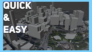
Blender GIS Add On

Vložit
- čas přidán 27. 08. 2024
- This tutorial demonstrates how to download the Blender GIS Add On tool so that you can visualize Open Street Map (OSM) data in a 3-D environment.
You can download Blender here - www.blender.org/
You can download the Blender GIS Add On here - github.com/dom...


After delaying installing Blender for more than 3 years, your helped and made things easier!
Thanks so much for the feedback, so glad the video helped to make it easier!
@@gissolutions4604 Hey, I have a question, how can you make mountains render?
Thank you so much for this. As an architecture student, this is treasure.
Thanks so much for the feedback and so glad it was helpful!
This works for me. You have solved my current headache you have my thanks good sir
I'm so glad, thanks so much for the feedback!
Love this. Thank you!
Here's an idea: since RenderDoc and MapsImporter gets a better terrain, you can combine these buildings with the terrain from RenderDoc.
Thanks for the feedback, truly appreciate it!
Hi can you help me I created 3 files but non of them import anything even though they are the right file type and are more than 0mb
Folks, unfortunately there appears to be some errors with the GIS Addon according to the Github site github.com/domlysz/BlenderGIS/issues?q=is%3Aopen So sorry for any inconvenience.
so how can we fix it?
Thank you for an excellent tutorial!
Thanks so much for the feedback and so glad it helped!
Thank you for the video, its useful. It would be perfect with the terrain topography.
Great, thanks so much for the feedback!
Sorry but this is only working 3.0 and below. Can you make 4.0 version of it?
Not working on mine too. Version 4.0.2
Thank you for being concise
Absolutely, thanks so much for the feedback!
Dude! this is amazing!
Thanks for sharing the knowledge and this add-on.
🤘
Thank you so much for the feedback, so glad it helped!
What version of blender are you using?
Hey! So it seems they have a unit count limit, unkknown what it is, but zoom level
Thanks so much for the feedback and providing that summary.
hey, when i press e to finish the image, it gives me a python error code. do you know what could be causing that?
Same here did you manage to resolve
Go back to a different version of blender
@@Maethenorthernwitch^
@@evanatkins21 wat version u recommend us to install ?
I have the latest version of blender
@@GGarwan I had an old version of 3.0 but any of them might work 🤷♂️
Great tutorial. Very clear!
Thanks so much for the feedback, so glad it helped!
Thank you for sharing. It is very useful for me.
Thanks so much for the feedback and glad you were successful!
Getting the height/topology data from GSM seems to be broken even with a new API key (throws error message). Depth data from Marine works. Using 3.2.2.
Thanks so much for the feedback.
I cant get it to work either :(
Absolutely brilliant!
Thanks so much for the feedback!
Great tutorial. As a noob, I have a question. How can I export a Map 'model' that can be used in Unreal Engine? I've tried .fbx and .glb but had some problems. I'm learning UE and am a beginner, Any advice would be appreciated.
Keep up the good work!
Thanks so much for reaching out and the kind comment. Unfortunately I'm unfamiliar with Unreal Engine. I did a search on this and came up with a link that might be helpful - all3dp.com/2/blender-to-unreal-engine-import-models-unreal-ue4/
When i press E ki then some error in map not visible
Could you please provide more detail about this error?
@@gissolutions4604 some what like this . After pressing E
Python: TypeError: temp_override() takes no positional arguments
The above exception was the direct cause of the following exception:
Traceback (most recent call last):
File "C:\Users\IvoSc\AppData\Roaming\Blender Foundation\Blender\4.0\scripts\addons\BlenderGIS-master\operators\view3d_mapviewer.py", line 959, in modal
adjust3Dview(
File "C:\Users\IvoSc\AppData\Roaming\Blender Foundation\Blender\4.0\scripts\addons\BlenderGIS-master\operators\utils\bgis_utils.py", line 108, in adjust3Dview
with context.temp_override(overrideContext):
SystemError: returned a result with an exception set
thankyour !! This is very important to me.
Thanks so much for the feedback, so glad it helped!
after pressing "geo maps" after the initial installation phase, 1:32
I go into map view and cant do anything but move the lighting... any help?
I also dont get the map to actually pop up...
@@dejondaly6317 Perhaps close out of Blender and re-open the application? I've tried to duplicate the issue, but seems to work fine on my end. Also, I'm assuming you're using the latest version of Blender?
@@gissolutions4604 yes, I have a version of the file right before I did that last step so I can go right before I did it and it keeps happening… thank you for the reply though
@@dejondaly6317 After selecting GIS>Web geodata...are you able to select Basemap? If so, have you tried changing the Source from Google to something else like OSM? Or is the option to select Basemap not available?
@@gissolutions4604 unfortunately, the same thing happens…
thankyou sooo much!
So glad it was helpful! Thanks for the feedback.
When I want to install the extension, it does not activate it, I do not know why, but I hope to find a solution. I am using Blender version 3.2.2
Thanks for the feedback. After downloading the Add-on zip file, open Blender. Go to Edit>Preferences>Add-ons. Do you see the "3D View: BlenderGIS" tool and click on the checkbox? Or is the Add-on just not showing?
Will this work on blender 2.78?
Not sure...give it a try and let me know.
No imaging library available. Image IO was not correctly installed. Please help
Same
hello I have a problem, that's after I clicked GET OSM there are nathing happened, it report "overpass query failed, check logos for more infos". what's wrong?
Unfortunately there appears to be issues with the GIS add on according to the Github site - github.com/domlysz/BlenderGIS/issues?q=is%3Aopen
@@gissolutions4604 thanks
I cant get the height map, I alredy have an API. I saw a lot of people with the same problem do you know a fix for it?
Both srtm and osm dont work
Which button are you pressing? 2:41
Thanks so much for your question, I'm just pressing the 'E' key on the keyboard.
e is the butten
Hi , when i select (get osm) option , An error occurs [ overpass query failed check logs]
How can i fix this if you could help me , thank you
I'd close out of Blender and try again. From my understanding, the 'overpass query fail' is OSM's overpass server hung up, this can be caused by many reasons like server overloaded, temporarily blacklisted IP, query quota exceeded. Perhaps close out of the program and try again?
I have the same problem
I have the same problem as well. I checked the Discussion tab of the Github where we can download the addon and there's someone encountering it too.
GIS/Web geodata/Basemap,error:No imaging library availavle.imageIO module was not correctly installed. -------What's going on?
In the video, I'm using Blender version 3.2.2. Looks like the Add-on tool has a minimum of version 2.83 required. Could that be the issue?
I'm getting the same issue but i'm on blender 3.4
I followed the steps, installed the add on, but unfortunately cant get the basemap to work. I am using 3.3 version blender. Tried reopening blender, tried changing sources as well.. no luck
Thanks for the feedback. Sounds like you have tried everything without any luck. If I figure out a solution, I’ll be sure to share it.
when i tried making the one world trade center in manhattan, the building was just a rectangle, but on the map view, it isnt. If that makes sense, what do i do to make it look right? thanks
better example, eiffel tower, i did it and it was just a weird rectangle going up,
Thanks so much for the feedback! Yeah, I tried the Eiffel Tower and it was a very weird rectangle as you described. I'm guessing it has something to do the the OSM data itself, opposed to the Blender process.
@@gissolutions4604 it might be because it sees the base of the tower as that shape, and it gets smaller, but it only registers the base because it is the biggest part of the tower, because like the one World Trade Center from a top view is a square.
@@NichoEdits I think you're right!
how do i add a plane under the land so i can 3d print it (because if i choose a part with land and water then the water and land will be on the same height and the difference wont be seen when 3d printing) ❤
Thanks so much for reaching out with your question. I think the attached link will help you to add a plane under the land. Please let me know if it works? somethingaboutmaps.wordpress.com/blender-relief-tutorial-the-plane/
@@gissolutions4604that helps a lot i can now use it for areas where there isnt water but how do i make the area where there is water have no plane under the land ❤❤
I got an Overpass Query failed error what do I do about that? 3.1.2 Blender
On the Github site, there appears to be some errors with the addon.
blender gis is so broken. using blender 2.83.10 through a laptop, I can't zoom in even if i click the area i want to zoom into.
Unfortunately there appears to be issues with the GIS add on according to the Github site - github.com/domlysz/BlenderGIS/issues?q=is%3Aopen
3:47 an Error shows up Please define the query...
Thanks so much for your feedback. What version of Blender are you using?
@@gissolutions4604 2.93.1
@@captainskullde I'd suggest upgrading to the 3 version series. Although the minimum version for this plugin is v2.83, I've heard that it performs better in v3x Please try that and let me know if you're still having issues.
sir what about textures
Hello, I am a user from Taiwan, I would like to ask you why I use GIS and finally show Overpass query failed, ckeck logs for more infos?
thanks you
Thank you so much for reaching out. Not sure that I completely understand you questions, would you mind asking it again?
I use the GIS Get OSM function, but in the end, instead of showing the topographic map, it shows: Overpass query failed, ckeck logs for more infos.
i don't know why
thanks for your reply
In the video, I'm using Blender version 3.2.2. Looks like the Add-on tool has a minimum of version 2.83 required. Could that be the issue?
Thank you
Thank you so much for the feedback, so glad it helped
awesome, thanks
Thanks so much for the feedback!
when i press e i get an error
Could you please explain the error in more detail?
@@gissolutions4604 I think it needs updating to support V4.0.2, i may be wrong tho
Google map not showing
I'm using Blender version 3.2.2. Looks like the Add-on tool has a minimum of version 2.83 required. Could that be the issue?
Can i get textures on it
I've never tried adding textures on it...
faced the same problem as my previous fellows
It might be missing the cache folder. Try this - Click on the GIS tab>Preferences. Go down to the section that says "Basemaps" and designate a folder where you want to use as a cache. Please let me know if this works?
BIG THANKS!