Google Earth Engine 101: An Introduction for Complete Beginners

Vložit
- čas přidán 27. 01. 2021
- Find the links to materials, slides and sample scripts, here:
arcg.is/0DmS590
Meet Earth Engine
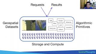
Google Earth Engine is a geospatial processing service. With Earth Engine, you can perform geospatial processing at scale, powered by Google Cloud Platform. The purpose of Earth Engine is to:
Provide an interactive platform for geospatial algorithm development at scale
Enable high-impact, data-driven science
Make substantive progress on global challenges that involve large geospatial datasets
Google Earth Engine combines a multi-petabyte catalog of satellite imagery and geospatial datasets with planetary-scale analysis capabilities and makes it available for scientists, researchers, and developers to detect changes, map trends, and quantify differences on the Earth's surface.
Presenter: Stace Maples
Please note that this workshop was for Stanford University affiliates, only, and that the recording is provided without access to Google Earth Engine, included. To sign up for Google Earth Engine, go to: signup.earthengine.google.com...
Description: The Earth Engine API (application programming interface) provides the ability to create your own algorithms to process raster and vector imagery. This session is geared toward people who would like to analyze satellite and vector data without access to computing resources typically required for that work on local computers. The session is hands-on, using the Earth Engine Javascript code editor.
The first part of the class will be an overview of the Google Earth Engine Platform, and Remote Sensing, in general. The second half will focus on accessing imagery, creating composites, and running analyses over stacks of images, computing statistics on imagery, creating charts and exporting the results of your analyses.
Prerequisites: No previous experience with Earth Engine or JavaScript is necessary for the beginner workshop, but programming experience, basic knowledge of remote sensing and/or GIS are highly desirable. Willingness to learn programming is required. Participants with no programming experience will require additional attention.
A production of the Stanford Geospatial Center, The Stanford Maps Library and The Branner Earth Sciences Library.


I must say that I love how organized the scripts are. Mr Maples deserves many thanks for this clear and well-prepared webinar which I learned a lot.
This video inspires me (and many others, I am sure!) Thank you very much. Hope this channel would continue to grow.
This was a super useful introduction! Thanks a lot!!!
thank you so much for making this public, i learnt and still learning from it whenever i watch it
i really needed this for my paper thanks !
Excellent! Very interesting lecture. Thanks a lot for sharing!!!
Thanks this is very helpful for a beginner like me.
Thank you, very useful
Thank you so much for sharing this video. I am a beginner using this for my bachelor thesis.
Glad it was helpful!
thank you for this informative video
This is a wonderful session. Very informative
Glad you think so!
Thanks for the good introduction. One small correction I would suggest here: around 19:00, you are talking about the spectral bands of Landsat images and mention that it would include the red-edge band. This is IMO not completely correct, as red-edge should cover the range between 680-730nm, which is not captured by any band of Landsat satellites.
this is correct. Thanks for the correction. Sometimes my excitement gets ahead of me.
How come i just learn about this tool. i have been coding for solid a decade.