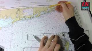
Navigation - Latitude and Longitudes

Vložit
- čas přidán 7. 09. 2024
- Captain Dave Medeiros talks about Latitude and Longitude
Looking to become a licensed mariner? Obtain your training and certification with Northeast Maritime Institute. We offer on-site and online training for US and International seafarers. Visit www.northeastmaritime.com for more information.
Explore and subscribe to our CZcams page for more maritime content!
Navigation Plotting is an essential skill for working in the maritime industry. This video is an introduction to some of those concepts. If you've spent lots of time on the water, but have not pursued a professional license, you should consider yourself a candidate for an Operator of Uninspected Passenger Vessels (OUPV) 6-Pack license. This license allows you to charter vessels with up to 6 paying passenger and is the first step to a career in the maritime industry, full-time or part-time!
Copyright © 2019 Northeast Maritime Institute


Thank you, I was not getting it until I found this video… appreciate your explanation, clear
This brings back memories 😢
So to see the actual results, could you put a dot on a random spot on the chart and, using the method you just taught, find it's coordinates so we can see the entire coordinate number you would have written down, for example, to radio the coast guard to come rescue you from a sinking vessel.
Would be easier if you called them by minutes and seconds. A lot less confusing for newbies.
Sorry, need a close up on the chart to make this understandable...
Sir may i know how to find the latitude and longitude of arrival?
The long part of the map is latitude not longitude. 😎. The numbers running north and south correspond to meridians of longitude.