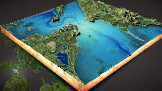
Top 5 Tips & Tricks for ArcGIS Pro - Change Your GIS Life!

Vložit
- čas přidán 4. 07. 2022
- What are your top 5 tips & tricks for ArcGIS Pro? In this video, I show you my top 5 most helpful aspects of the best GIS software out there. Let me know in the comments what are your best tips for ArcGIS Pro?
Dr. Jason VanHorn Faculty page calvin.edu/directory/people/j...
Calvin GIS Certificate & GIS Master's Online calvin.edu/academics/departme...


I have been using GIS for 15 years and I DID NOT know about the connect data folder to all projects. Changed my life!
Great to hear!!
Good videos! Subscribed
THIS CHANGED MY LIFE!!!
These are super helpful tips, thanks! No more clicking and unclicking different imagery year layers
Glad it was helpful!
Fabulous! I've added this info to our in-house Helpful Hints with a link to this video. :)
Great tips, very well presented!
Thanks a lot. very informative.
love your style (corny) :) fantastic ! and ive learn some new things
Wow, Thank you
Thanks 🙏
good one.
I’m going to use the link map views, thank you.
We need more tips))) 😊
These are great
Linked map views was the one I learned. Thank you!
Glad it was helpful!
Can ArcGIS Pro create a map theme to switch different layer to show in the same map but different layout view?
Hello Sir, thank you for the helpful video. May I ask what computer or laptop you use to run arcGIS pro? I need a new laptop that can run the application faster, as my current one is too slow and it is important for my masters research to use arcgis. Thank you
I'm using a Windows 10 lap top with 32GB of ram, a 500GB SSD, and Intel(R) Core(TM) i7-8665U CPU @ 1.90GHz 2.11 GHz. :)
thanks body
You are welcome.
Link views...AWESOME!
I love it so much!
I need to work in a real project to apply this tricks on it and my biggest to travel abroad and work with eny special team who's save environment pls can y tell me how can i do this with all my regards
greetings I work in forestry and my colleagues work with WinGIS 2003, the maps they use are old folders and they only go to that program. Can I use those maps in ArcGIS 3.0? I installed them at work.
winGis is old program from 2003 year AND that program works in .amp format
WinGis 2003 Software has long been out of support
the New Software Like ArcGIS or QGis And that type of file .amp file winGis cannot be translated into any of the more modern ones !?
Exp. shp, .dxf, .gpx, .mif …..
My questions is Maybe that file .amp can be converted it to the new file shp.Dft gpx. ….
Hi @bajonivideos, I'm not sure about that conversion. Here are all the format extensions available with the Interoperability Extension for ArcGIS Pro 3.0 - pro.arcgis.com/en/pro-app/3.0/help/data/data-interoperability/supported-formats-with-the-data-interoperability-extension.htm.
@@MapYoda file in this software are .amp
That file don’t support newer software
But i hear that is possible to conver.amp to shp, .dxf, .gpx, .mif
I need help 😁
You said you knew what the aliases meant in your column table. How did you know?
Great question. When you download table data from the USA Census Bureau, the metadata comes with the files in the download. So you can read what each one of the column headers mean. :)
Hi M !
How to get a formation in arcgis pro to you ? Please I want getting an anwser to my request.
What is your GIS question?
This program is an absolute nightmare. From not understanding Arc or the purpose of GIS at my job... to being forced to load ArcPro onto the machine. Its enough to make me jump off a bridge.
No jumping off bridges, please hang in there. I totally understand. It sounds like you need training and your work should help you get trained. You can check out a fuller course I teach at LinkedIn Learning which should help: tinyurl.com/c3vy6mrt.
It takes times, learning never stops, and you can do this.
My vid on first day with ArcGIS Pro might help too. czcams.com/video/vg3j6130jtU/video.htmlsi=zeble7dLquVd8aFv
I have no desire to learn about GIS. no one understands why we collect data. The data they give us is shady. They don't get it...I dont get it... no one really cares.... and yet they spend 250k a year keeping Arc going. The bridge is getting closer.
@@MapYoda sorry for the short reply. I need to tell you my situation at work so you understand. I work for a county in Washington State. 4 years ago I applied for a job that mentioned zero about GIS. I got the job and on day one no one knew why I was there or what I should be doing. Because I work in the planning department I was told I better learn GIS. I was introduced to 35 years of developed mapping on day 2 of my job. I can remember when I left work that day, I puked on the way home, thinking....wtf did I get myself into. Day 3... I verbally told everyone I have zero experience with GIS and I dont know what it is or what I'm supposed to do with it. For 4 years now I have struggled to grasp the concept of why its even in the office. No one ever asks us questions, asks us for information. Its like we don't even exist. Now 2 weeks ago ARCPRO was installed on my machine and I am utterly lost. I have no experience with any of this stuff. Nothing. I sit there all day... 5 days a week... pretending I know wtc I am doing. I make myself look busy... try to help out whomever with what I can and thats all I can offer. There is no amount of training that will help me. This has been developed for 35 years. The GIS tech is set to retire in January and they are trying to hire but no one is applying.
This form of mapping isn't easy... its beyond a normal person's way of thinking. I have been lost for 4 years and will continue to be lost until they either dump the entire GIS mentality or I jump off a bridge.
No one ever mentions how brutally hard this GIS world is on these posts. I dont understand why anyone would want to mentally murder their brains either. Its not worth the money.
😂 where is the file ... print ?
What a joke of a program. ESRI should be embarrassed to say the least.
With the amount of videos on youtube explaining arc pro.... it should make a point that millions of users have no idea how to use the program.... or whay they are doing. The bridge is in site.
I hear you. Hang in there if you are called to keep going with GIS and know you are not alone. GIS isn't meant to be easy, but it is powerful. It is more than just software.
When my students struggle, it's primarily because of the is disconnect they have with spatial concepts rooted in geographic theory. Anyone can click buttons, but not everyone can make a spatial data visualization situated in real spatial theories.
You can make a mapping software for all, but if you want to construct software pathway algorithms that serve as the foundation and advancement for spatial analysis, then it's complicated. I have my critiques of the ESRI software too, but any serious GIS software will be tightly coupled with geography, which makes it hard.
ArcPro and the entire ESRI software ecosystem isn't perfect, but there is no equivalent and nothing that can match the richness and depth of what can be done with it.
GIS is hard for many people, but that isn't the fault of ESRI. Spatial thinking and geographic theory is an entire academic discipline from which much of the ArcPro works to operationalize.
Accept my best for you.