How to Find Latitude and Longitude without GPS | Intro to coordinate systems

Vložit
- čas přidán 21. 07. 2024
- Simple explanation of How to find Latitude and Longitude without GPS. Without your understanding of Latitude and Longitude you can not define Position which is one of the Prime Data in Offshore Surveying. #Latitude #Longitude #Navigation #OffshorePosition #CareerGuide #SurveyTraining #StarNavigation
Please Subscribe and don't forget to click the bell icon.
Must see videos for Offshore Career :-
Earn big money in Offshore Surveying | A Career Upgrade • Offshore Surveying | A...
WHERE IS NORTH? • WHERE IS NORTH?
What is Position and GPS? Career in Offshore Surveying • What is Position and GPS?
Simple Explanation of Latitude and Longitude • Latitude and Longitude...
Moon Phases, Eclipses and Ocean Tide - Introduction • What is a Super moon, ...
Ocean tide - How Tide happens | Tidal Patterns • Ocean tide - How Tide ...
How & from where we measure Tide | Tidal Datum- Part 3 • How & from where we me...
PowerPoint Animation, Tips & Tricks Playlist • PowerPoint Animation, ...
Music Courtesy:
Guiton Sketch by Kevin MacLeod is licensed under a Creative Commons Attribution 4.0 license. creativecommons.org/licenses/...
Source: incompetech.com/music/royalty-...
Artist: incompetech.com/


Welcome to my Learning Channel. Thank you for joining us for the premiere of this video. If you are new here, check out some of the links in the description which you will find helpful.
I thank you all for subscribing to my channel. This helps me a lot in making these videos. Give me a like and comment your queries below. Your LIKE and COMMENT will help this video rank better. Thanks
So Relax and enjoy the video. Take note or rewind, Share the video with your friends and ask them join my learning channel.
Wow this is fantastic! I’m listening to a book on longitude and Harrison’s clocks. I was a bit confused with the whole longitude and latitude calculation until I saw this video! Excellently explained you got s new sub! Thanks!
I am honored
Just found your videos - it's amazing how quickly one can learn from a person who understands their field so well.
It is an amazing feeling when you see that someone learns and appreciates. I Thank You my friend.
You shattered the mystery that has always surrounded this for me! Excellent video, thank you!
Hey @Krall Space Thank you very much for you kind comment. I deeply appreciate it mate.
This is a very educational video, I personally went to Knight school to learn Astro navigation which is way above my head the way it was talk to me all the way that I perceived it, on this video it was explained so much easier, thank you very much for taking me back to those many hours of learning at school. Reg Marchant.
Such great stuff. Thank you for an excellent explanation.
Great insight on How to find Latitude and Longitude without GPS
Thanks mate, thanks for dropping by. I hope you will like my other videos too.
Great job. I like how you explained everything. I have been thinking of taking my kids out to do an experiment with either a demonstration of the Coriolis effect or seeing if we can find or approximate our latitude or other such experiments. Thank you for your time and I liked your video
Appreciate for your time to see my little video and your encouraging comment. Thanks and wish you the best. Kids normally love these practical experiments. You can even buy some cheap sextant from Amazon.
Great explanation. Thank you for speaking slowly, it made it easy to understand you.
Concise and understandable. Thank you!
That is the perfect explanation. Thank you for your video sir.
Hi Avijit, good effort ..Interesting and informative...All the best.
Thanks for your encouraging words. 👍
I'm taking an introductory course in astronomy this semester. This video was super helpful!
I am greatly honored. 🙏
THANK YOU.! -יעקב-
Cool info. Thanks for sharing in a way that’s easy to understand.
Hey thanks mate.
Appreciate the video my firend. Learned a lot!!
Thank you
Excellent video explaining how longitude is calculated.
This is really interesting and gives an insight into how navigation is done . Thank you for the video , best wishes from England .
Appreciate your time and thanks so much.
THANK YOU! I’ve wondered for years how to find longitude, yes really! I think you must have an accurate timepiece to know the time at your origin after you’ve left the spot.
How can a person calculate their longitude without a timepiece? You seem most likely to know. Does the Surya Siddhanta explain? How?
Thank you again! I just found your channel and am subscribing today.
Thank you very much for visiting my channel and for your kind comments. Depending on how accurately you want to measure your Longitude, you need to have that type of timepiece. In today's technology, most of our high end clocks and pretty accurate and can only loose about a second a day which is okay for general navigation. But ofcourse you need to know the solar noon time and sun inclination at your place and sync your click.
To tell you truth, I am not really sure how you can find Longitude without a time piece. But I have read that some ancient mariners used to take multiple star vertical angles and their position at the sky to calculate approx Longitude they are in. But I am not conversant to that calculation.
No I have not read Surya Sidhanta, I would love to if I can get my hands on an original copy which can be very hard.
Thanks again. I will try to find the solution to your question when I find some time.
Great video, it was really well explained.
Good video.... Very informative.
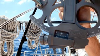
Great explanation. I dove too deep and got myself all messed up I the details. This concise explanation helped me understand the WHAT I am trying to accomplish with a sextant. I was too wrapped up in the HOW.
Thank you sir.
Start by learning a noon shot, aka, latitude by local apparent noon. Contrary to popular belief, the calculations are easy. Taking an accurate observation is what's most challenging. Like many things, it gets less so with repetition.
Awesome thank you
This was helpful, thank you
Thank you so much for your video. I enjoyed it very much.
Appreciate your kind comment.
Very good tips.
Thank you !
The pleasure is mine
Excellent Video.. cleared all of my doubts
Thanks mate. Happy to hear that. There are many more videos as such you may find useful :)
Very well explained my friend.
🙏
plain and simple even I undersood it thanks
Thanks. That is the moto of my channel, trying to explain things in simple terms.
Great video ,many thanks
Thanks and glad you liked it.
why is this not a part of secondary education?
Done nice. Thanks
Welcome.
I saw a movie ESCAPE n this thing came into my mind how can I find latitude n longitude n after 2 hours I came across your video... Thanks
Happy to help 😊
You have an excellent teaching style. I wish I could practice with a sextant. Unfortunately, I do not live near the coast. I also worry about damaging my eyes using a sextant looking at the sun.
When the sun is about 10 deg above horizon it is okay to look at sun, especially during sunset. Thanks for visiting.
Sextants have filters to prevent damage to your eyes.
Excellent
Exciting explanation
Hi, Thank you for visiting. I hope you left me a Thumbs Up 🙂... Do check out my other videos on similar lines. Thanks again.
This was awesome 👌
Thanks Bryan.
Good job..
How did the ancient Hindus measure longitude without a mechanical clock? Please explain the Lunar eclipse method. Since all civilizations discovered so far measured longitude using the same 360° I think they must have have a method for calculating the east-west angle. Maybe star angles? I don’t know. Do you?
The concept of Latitude and Longitude is fairly new. Ancient Indians, Babilonians and Polynesians used mainly Rising and Setting Sun as markers. And lots of ancient texts also depicts that these ancient mariners knew their stars. I am not so conversant with ancient navigation but I know that most of the navigation was coastal except perhaps for polynesians. And thats where my knowledge ends. :)
thank u sir. is there any possibility to use natural stone to find latitude. Becoz sun rays gets polarised towards poles. natural stones like calcite differentiate natural and artificial light. Just by focusing smart phone on natural stone in sun light can we measure latitude?
Thats an interesting theory, never heard about it.
No, that is not possible. Calcite can split a beam of light into two polarised rays and the skylight is polarised to some degree, which is why outdoor photographers use polarising filters - they make the sky look a nice deep blue colour. . It would only tell you very approximately if you were facing towards or away from the Sun.
Thanks for your nice video. So my question is: In the 18th century, they would set their clock(marine chronometer) with the reference noon time (Greenwich) on the date of departure, and it was their reference for the rest of the journey right?? Because every other video that I've watched had taken the GMT noon from the internet, and it wasn't possible in the 18th 😅😂. And second question is: before the Harison's invention, how would the sailor measure the Long.?? I red two articles about lunar distance and measurements of celastical objects with sextant, but I barely understood anything at all. Would you please explain🙏🙏🙏
Howdy mate. Thanks for being here. Firstly, yes Reference noon time is used throughout the journey and they knew about this and making the perfect clock took long time that could be well suited for marine environment. Secondly, lunar observation not accurate as it is too close to earth. Ancient times it was easy for them to calculate their Latitude with sextant angle of Polaris. Longitude was difficult but people also used sun altitudes to roughly measure for Longitude. Though it was not accurate so most of the expeditions normally followed coastlines. With a little bit of understanding and simple math you can be as accurate as +/- 30 miles and you just needed a sextant. And at the time when world map was still being drawn by hands and imagination, +/- 30 miles is very good accuracy. Well, many did not make it but some did.
now where do I get astrolabe or sextant? jk :) good video mate... nicely done. very good animation.
*_Thank you_*
Than u sir, one thing please, I could not find the correct longitude in my present place..watching many tutotrial in youtube does'nt help , in GPS it show Lat 36*-28N, Long 47*-16.9W
My current local time is 0240am , GMT is 0540am ZD-3W ..when I solve the problem its not showing the same result on my Actual GPS
,,Any advised to solve the issue thank u sir.
Hello my friend, I apologise, I somehow missed your comment. As you are in the northern hemisphere, finding latitude is quite simple. If you have a marine sextant, find the vertical angle to polaris. Your local time is behind GMT. You need to know what time if the noon or sun is at highest point at GMT on that given day and what time is your Local noon. Find the time difference between the two. say if the time difference is 3 hours then you are 15° x 3 Hrs = 45° away from the GMT. You can take it to very accurate level if you want to calculate it accurately. Earth rotates every 23 hours and 56 minutes and not 24 hours. So if your clock (not stipulated date and time zone) is accurate and you can measure the local noon correctly, then you can find your position say within +/- 2 miles. I hope it helps. I am sorry again for this late reply.
Can you explain about inertial navigation please
3 axis gyro plus 3 axis acceleration plus GNSS plus navigational computation.
Sir any different in latitude when we measure it on sea and Same on earth by north star.
Hi, there is no difference in Latitude and it does not matter where you are measuring from. But yes as Land and Sea is not in the same place there will be a difference. There is also a factor of Height. Normally at sea, on a ship you are high up the surface and that makes slight difference. Also on Land, Horizon is not fully defined so your measured vertical angle will have some error. I hope I am able to answer your question.
@@JAOM On land you can use an artificial horizon. It's also good for practice.
Bruhh , i want to know , can i learn the techniques for proper navigation through sea route , because learning is my passion , i welcome every skill and experience.. it is indeed interesting that i can learn sea navigation, rge device you use and some mathematical calculations
Well I advice that you can get yourself any old Nautical Chart (Admiralty Charts) and some Almanacs if you can. Try deciphering the charts and almanac, Rear some Rule of the Road (ROR) and you are halfway there. My channel has some cool maths and easy to understand (hopefully) basics which, if you are really interested can give you lots of information on real world sea navigation. Best wishes and Thanks for visiting.
@@JAOM thanks pal , I will surely follow your helpful advice
Is it possible or is there a way to imprint angles or engrave some kind of system to calculate distance and angles on a sailboat front windshield and is there a way to calculate and navigate by calculating inside your head without holding any devices like sexton device? That way all the sailor have to do is look at the clock, the front windshield, the stars, the compass and he can navigate.
Will you be able to come up with easy equations step by step list to memorize
Hi @JohnDoe You have a very valid question and I appreciate for asking me this. In ancient times when there was no sextant or astrolabe, people still were able to find their way back home. In modern times, we are so deeply entrenched in technology that we even lost our ability to calculate a simple multiplication without the help of calculator.
many a times I thought of making such videos of doing calculations without anything may just a wristwatch, sun, stars, some sticks, our own thumb and an understanding of how things work. Yes I understand what you are asking me and I can do that but not make a list here in the comments. But believe me when I say that there are hundreds of much better people in the CZcams itself who have made kinda similar videos, albeit separate separate video. May be someday, may be... but then it takes lot of my time to make such videos and with almost no views as my channel is very small and "dry".
Some Day John Doe, some day when I retire and get all white and crinkled.... Peace my friend. 🙏
After watching a few more videos, I think with a little practice I can do it. I thought about the thumb earlier this morning but threw that thought away bc of accuracy, but now that you mentioned stick, I think a little lightbulb in me lit up. After looking more into it, I kind of have an idea of how everything works and it's always a triangle to work with, not a lot of math. Everything seemed a bit complicated this morning but now it's very "doable."
@JohnDoe-kc8si there you go. You yourself has answered your question. Most of the basic navigation and surveying questions can be answered with a triangle and tan theta. You dont need a thumb or stick, if you draw a straight and vertical line of 10cm or even 1 foot in your windscreen. You can guess most distances with that little line if you know the distance of your eyes from windscreen. Cheers.
@@JAOM thanks to your video and clear explanations, which gave me most of the insights. I mean, I still haven't done it yet but now it became something I know I can do in just a day of practice, thanks to you so cheers. See ya.
Would you have to know your speed for this to work?
No. But with speed and heading direction you can have dead reconning if you start from a known point.
How can i find latitude during day time.
Hi friend, thanks for visiting. Though it seems a bit complicated but this too can be done. At any given time, sun altitude (angle from horizon) depends on your position and time. So if you got a table to find solar declination compared to the celestial equator, and exact Local Noon of your current position, then there is a simple equation. Your Local Latitude = 90 - Solar Height at Local Noon + Solar Declination. I do believe these Solar Declination table can easily be found in the net and you will have to first figure out (measure) Solar height or sun altitude at your Local Noon. Frankly I have not done that calculation, yet, but I believe it can be done. Its tricky to use some direct method of looking at sun during noon time. Try seeing my latest video of how to find Sun Azimuth, where I have given a link, where you can find Sun Altitude and Sun Azimuth from given time and position. Hope this helps.
Astrolabe and sextant
Gotta have an accurate chronometer, sextant, up to date nautical almanac, tables of computed altitude and azimuth/be really good at spherical trigonometry, or you're still SOL.
Yes, for precise navigation. But for noon Sun sights you can get away with a quartz watch set to GMT and a table of the Sun's declination and the table of "equation of time". Will be good to about 60 nm. A good calculator can also give a fair value for declination from a simple formula.
@@karhukivi The average $15-$20 quartz watch has an accuracy of +/- 20 seconds a month. That's plenty good, even for stars or planets because the rate is generally more consistent than even the best mechanical chronometer, cool as they are. As soon as quartz watches became cheap and readily available, the old ships' chronometer become nothing more than a tradition, being "rated" daily by the third mate, but rarely relied upon as the sole accurate timepiece for celestial navigation. As you're well well aware, an error of one minute of time is equal to only four minutes of or arc, or four miles.
@@frankmiller95 That should be 4 seconds of time equals 1 nm. My point was that with only a watch, calculator and no almanac, a noon sight can still be good to about 60nm using a formula for declination and another for the equation of time.
@@karhukivi Unh uh. Regardless, an error of up to 60 miles is fine of you're in the middle of the ocean, not so much when making a landfall.
Each time zone is one hour/60 minutes of time, 15 degrees of arc, or (theoretically, for the purposes of celestial navigation) 900 miles of distance. Therefore each degree (60 miles at the equator) of longitude is equal to 4 minutes of time. lf you're on the far edge of your time zone, celestial events will generally occur 30 minutes before or after the time on your clock or watch, which is set to the zone meridian. Accordingly, an error of one minute of time, assuming there are no others, is equal to 4 minutes of arc, or 4 nautical miles. N'est ce pas?
l am intimately familiar with this formula due to the prick Dutch captain, Rien Kouw, of my first ship as third mate. His first question to me each morning when he and his disgusting bourbon breath arrived on the bridge was invariably, "Mister Mate, what time is noon?" By that he meant LAN/meridian transit of the sun. With a quick glance at the Nautical Almanac for that day and a DR plot of our longitude at that time, it was easy to deduce a suitably accurate prediction of the time of LAN for our "noon shot(s).
As for your assertion that it's possible to deduce "accurate" longitude without a reasonably accurate chronometer, that's a little difficult to swallow. While there's no way to know for sure, l suspect the ghost of Admiral Cloudesley Shovell and numerous other professionally trained navigators, including the descendants of Nathaniel Bowditch, whom l knew when we were kids, would concur.
@@frankmiller95 In fact, a time error of one minute is equal to an error of 15 minutes of arc, or 15 miles. The problem with quartz wristwatches is that they are usually set to local time and one never knows when the battery will run out. These days a chronometer is simply a dedicated electronic clock or watch,, set to GMT and provided with a reliable power supply.
Can we find longitude by sextant
No, as far I know and understand.
Yes, with two or more position lines you get a position with both latitude and longitude, but you need a chronometer almanac and some method of doing the spherical trig aka "sight reductions".
Latitud ?
I understand that the distance from the North Star at your Zenith to the North Pole is about 51 miles.
Hi Gregg, I am not sure about that. If you can please explain then I will learn something new. 🙂
@@JAOM From an astronomy book I found how many minutes/seconds Polaris is away from the Pole. Another book gave that distance in miles which I rounded off (about) since the Earth isn't a perfect sphere.
If Polaris was at the same elevation ("altitude") as the Pole then you can know your Latitude. But if not then you can be up to about 51 miles off north or south.
@@greggweber9967 I got you now. You must know that earths rotational axis is said to be 23.5 degree but that is not always true. It fluctuates between 23.1 and 23.7. So our celestial North is not actually pointing towards Polaris. And this wooble of earths axis was first measured by Chandler (cant remember full name). and it comes back to original direction in some 10-11 thousand years... if some thousands of years our celestial North will point towards Vega. So yeh... there you go. I now understand you. Thanks for taking your time.
@@JAOM I understand reading in an old book that someone in antiquity had earlier figured that out but I can't remember who or when.
@@swmplvr you mean earth is a traingle? Never heard about that. Very interesting theory you have. All I learned and practiced and taught for last 40 years is a lie? Nah mate I am too old to change my story now. And its been working fine for me taking all the wobble and spin and curve and sphere. Why change now.
How could they use this method for hundreds of years when they didn't have mechanical clocks
Before the precise clock was machined, people used mostly Latitude reference and somewhat crude calculation of Longitude. But they could also calculate Latitude and Longitude by star observation. The like of Spanish Explorers and early English explorers used only star as primary guide. That's why they used to land in different places than originally intended. 😀
can i have robux
50 virtual Robux to @ATSGaming