Barcelona's map, EXPLAINED

Vložit
- čas přidán 7. 06. 2024
- Broaden your understanding of the world. Try Ground News today and get 40% off your subscription by going to ground.news/BrightTrip
Beautiful travel guides - brighttrip.com/
FOLLOW ON SOCIAL
Bright Trip Newsletter: mailchi.mp/brighttrip.com/sig...
Bright Trip on IG: / bright.trip
Bright Trip on Pinterest: / brighttriptravel
Bright Trip on Facebook: / brighttripteam
Bright Trip on Twitter: / trip_bright
ABOUT BRIGHT TRIP
Bright Trip creates video-based travel courses to help you travel smarter. From our location courses that visually demystify places like Tokyo, London, Costa Rica, or Cape Town to our skills courses that cover how to travel solo, with kids, or how to document your travels more effectively and efficiently - each course is created by real travelers, like you, and aims to create a community of curious travelers that are eager to travel smarter.
For business inquiries: Partnerships@BrightTrip.com
CREDITS
Executive Producer: Andrew McGarrity
Video: Driaan Louw
Music: MusicBed
www.musicbed.com/


Compare news coverage. Spot media bias. Avoid algorithms. Try Ground News today and get 40% off your subscription by going to ground.news/BrightTrip
0:56 you got the rivers inverted there.
yup
@14:18 that would be the Mediterranean sea, not the ocean.
Thanks, now it makes sense! I was wondering how can I remember seeing Besos Mar if it is so far from the city center :-)
I'm from Barcelona. And, as many other comments, I must say your video is very, very accurate. Great video! Yes, there are minor (very minor) mistakes, but, mate, the work you've done is great! Thanks. And also, thanks for trying to keep the real catalan names of everything. Again, congratulations
In my opinion, you missed one of the most curious things about Cerda's urbanistic plan. Avinguda del Paral·lel is aligned to the Earth's parallel lines and Avinguda Meridiana is aligned to the Earth's meridians. Extending two imaginary lines along those two avenues, they would intercept each other with a perfect 90º angle, right over the old Barcelona lighthouse from 1772 called Torre del Rellotge (The clock tower) at the port by the seaside. 🤓🤓
This distribution makes the whole thing make much more sense. Opposite to the classical Nort-South orientation in most North American cities, in Barcelona, thanks to Cerda's geniality, every side of every block receives direct sunlight at some point during the day. This is absolutely genius. 👏👏👏👏👏
As a resident of Barcelona, this is the most comprehensive, engaging and concise history of the city I've seen. Thank you!
you got the rivers wrong at 0:55. They are one each other's place. But apart from that, as a Catalan I find most of your historic and urban elements very well explained.
Fabulous video, very well done and explained! At 0:51 min, the rivers are the other way round. West Llobregat, east Besòs.
Great piece of info, thank you!
@@BrightTripTravel Do you plan to fix that? Don't get me wrong, the video is perfect, one of the best I've seen in all youtube. But this little thing taints it a little.
Also noticed that the river names are misplaced. Anyway loved the video too
@@cassioiks unfortunately, fixing and reposting videos on youtube is a suicide in terms of views and engagement. Blame the game, not the player :(
@@DrPepperone YT should have an option of allowing the temporary edition of a video within a short period of time (a week or two as much) and minor corrections (to avoid a misuse of that function), in order to correct this minor mistakes without affecting the views and engagement...😅
I know for a fact that you did an amazing research for this video. Accurate information and great maps you have to dig in archives to find in goog quality. As a catalan and barcelonian, thank you.
By the way, you live in my dream house with those views to Montserrat, a sacred and magic mountain for many catalans.
As a catalan, thanks to explain really well the story of the map of our capital :)
Well…home to Picasso,…he lived there for some years but was Born and raised in Malaga (Andalucía) and lived most of his adult life in Paris.
Fun Fact: Eixample means to widen in catalan. So Barri de l'Eixample is the widening quarter
I've watched so many videos about Barcelona's history (I visited a year ago and fell completely in love with the city), but I've never heard them narrated by a South African accent. Very comforting.
A part from the minor river swapping error, the video is really good, great job!
Barcelona was where my husband and I went for our honeymoon, and I can't think of a better city to spend a week!
Some of yall should clean your ears out. He said the city was/is home to those people, he didn’t say they where born there. Shut up about it everyone knows Messi is from Argentina and Picasso was from Málaga.
Increíble, un resum increíble. Tota una feinada, company.
Gràcies, i felicitats per la bona feina.
Amazing work here, pal.
Keep the good work.
Surely, this will help lots of people who just came to the city looking for paella... There are so many places to see.
All the cities have a long history to be told, thank you for condensing such long history of my city, so beautifully, in less than 20 minutes.
A million thanks, company.
As a person from Barcelona I love this video! But at 6:40, the map shows the territories of the Crown of Aragon, which were the Principality of Catalonia, and the kingdoms of Aragon, Valencia and Mallorca. By 1653, Spain was already formed. Many People considers that Spain was formed when the king Ferdinand II of the Crown of Aragon and the queen Isabella I of Castile married in 1469 (Catholics Monarchs). The 2 crowns, had their own laws and worked practically as different states. Basically Spain was a decentralized state. But when the Succession War began, Catalonians decided to support the Habsburgs because of Philip V's ideas of centralization of Spain. When Catalonia was abandoned by its Allies and lost the war, Philip V retired all privileges Catalonia had and they punished them with things like, as you mentioned, construction limitations
He explains that Aragón and Catunya were two completely separated regions, but to not mention the fact that were part of the same crown is a huge mistake.
@@sergiobasilio8098it's not a mistake , Catalunya until 1714, was inside the Aragón Crown...but with full self goverment
@@01RAMONATOR Is that so? I believed that those sort of Kingdoms had Councils and such, but that they did respond to Aragon's monarch
That was just a marriage and a political alliance, but Castile and Aragon where two different crowns with their own institutions. Spain appears later, it's difficult to determine when though. I like to think it officially starts in 1833, whit the readministration of the territories and the creation of provinces, abolishing the different institutions and kingdoms inside
@@c.n.i7105 Catalunya, Valéncia and Mallorca was kingdoms (Principat in Catalunya case), with full independence inside de Aragon, Crown,
Good effort! A few minor glitches but one of the best concise timelines I’ve seen of this fantastic city.
Great video!
One critical change for the city that the Olympics brought was the construction of "Rondas", Ronda de Dalt and Ronda Litoral. 2 "urban highways" at the edges of the city (Dalt on the mountain neighborhoods, Litoral at the sea) limited to 80km/h which massively improved mobility.
Thx for this excellent visual explanation of Barcelona’s growth. Outstanding insights not available in one cohesive, concise narrative anywhere else
Glad it was helpful!
Fantastic! That's what I call a good informative video. Pointing on a map different locations and then immediately supporting your explanations with real image (pictures) of those locations can make anyone understand what you're talking about.
Excellent information. Keep these coming.
Being from Barcelona, must say this is such a well made video! Thank you!
Glad you enjoyed it!
Great video! It's incredible how much history there's in every detail and every part of the city!
LLobregat and besos rivers are swapped in the map
Amazing video! Very accurate and well explained, coming from a barcelona local :)
Great video, thanks, and I must say, it’s the first time I really got interested in the company sponsoring the video and I’m very impressed by what they’ve created❤️✊🏻
Congrats! as from someone born and bred in Barcelona, I really enjoyed this video
Wow. Visited Barcelona last year and now, thanks to this video, a lot of things we noticed finally fall into place.
Amazing video!
Thanks for being so respectful with the catalan society and their history across Barcelona, as well as for the research about the composition of the city. It has been a really enjoyable pleasure to see the video. Good job.
Loved it! Thanks for you work!
Thanks a lot for a great video.
Impressive, thanks for treating us with such respect!
Great video, I just want to add a minor detail. As you perfectly said, Avinguda del Paralel is called that way because it runs parallel to the equator (from east to west) like the parallel lines of a globe. In the same way, Avinguda Meridiana is called that way because it goes perfectly from north to south like the same globe meridians.
As a Barcelonan I can only say congratulations on an amazing job 👏 I learnt from this video things about my city which i did not expect, subscribed, thank you for this!
absolutely insane video, i now love barcelona even more
Lovely video, and accurate information. Thanks!
Also iconic camerawork from the olympic - A lot of sports were filmed with either art or architecture in the background. Segrada Familia was in all pictures from the diving competition.
Whoa that's amazing. Thanks for sharing!
Fascinating video about the development of a fascinating city. Tons of research well-presented. I love the place. Gracias Mil ...
Great video! I'm a Barcelona resident (well, a bit up the coast now) and appreciated the effort you put into this. I look forward to watching your other videos!
Awesome, thank you!
great work mate ! super detailed and quite accurate
Congratulations. You explained it very well.
Amazing work, you explain it like a true local
what a high quality & informative video - thank you!!
Yea, that was the goal!
Amazing video!
Super interesting and well done video
great video!
nice vid mate, well explained, I'm from Catalonia, nice to hear the difference between us and Spain, great job!
Fantastic video, very well explained and mostly accurate :)) Here's some engagement for the algorithm!!
Fantastic breakdown! It's fascinating how some locations maintain the essence of their original purposes, despite their transformations over time. Places like La Rambla often leave a peculiar aftertaste if you linger too long, and Plaça Espanya has a similar vibe. It’s also intriguing to witness Barcelona embracing Ildefons Cerdà’s visionary urban plan. It’s great to see such recognition for a true mastermind in city planning.
Amazing video.
Nice video!
Fantastic video
"Bullet shaped skyscraper ..." you handle euphemism well
Really great, thanks a lot. Llobregat and Besòs rivers are on opposite sides, though.
I learnt more from your video than from all the years i lived in barcelona.
Thanks!
Thank you!
The way u explain this city, it amazing
New cities around the world should look at barcelona plan. 😊
Man! I'm from Barcelona and you nailed it!!
What a compliment, thank you!
@brighttriptravel
you got the two rivers at the start confused -- llobregat is on the left, and Besos, to the right, ;)
Great facts!!! Really enjoyed watching this.
Great video! Earned a gold star by acknowledging your mistake at 13:53
An excellent and comprehensive overview of the city, few foreigners get so much right. Allow me to add a few details.
- As pointed out elsewhere, the labels on the rivers, the Besos and Llobregat are inverted.
- Besides the Parallel running, well, parallel to the Equator, the Meridiana runs perfectly north to south, over an Earth's meridian, hence its name. They were meant to converge on the Port Vell, where the historic clock tower is, but by practical reasons, it misses by a few feet.
- The very slim city blocks of the Barceloneta are meant to provide everyone with light an air. This, as you well point out, was better achieved by Cerdá's plan with the hollow city blocks in the Eixample.
- BTW, the inside of those blocks are not 'mainly' parking space. There were not many cars when the Plan Cerdá was being mended, they could park in the sidewalk all right, no need for dedicated parking space. What they were destined for was for commercial space. The many stores you see in the Eixample stretch well into the center of the block, providing lots of rental income to the landowners. Some of those commercial spaces were converted to parking, but that was a later adaptation, it was not by design. The roof over the back of the commercial spaces becomes the terrace for the high-end apartments above the store. Notice that at the time, lower floors were better priced than higher ones.
- You forgot to mention along the main avenues the Passeig de Gracia, which is Barcelona's equivalent to the Parisian Avenue des Champs-Élysées, with many of the same high-end brands on it. It was the connection from the old town to the town of Gracia, hence its name.
- Via Laietana was in no one's plans. It was a later addition because both the Eixample and the port grew a lot, and they needed a connection, thus, needs must. The most significant houses in its way were not demolished but dismantled and re-assembled within the Gothic Quarter, in the area between the Cathedral and Sant Jaume.
Great comment and extra info! But you're a bit wrong on the last point. Via Laietana was part of Cerdà's plan, along with a horizontal street cutting all Ciutat Vella and another vertical one cutting through el Raval (those 2 were never built).
But yeah, you're right in that it was left aside and recovered later on (1907-1908) because of what you already pointed out :)
0:51 the rivers are flipped, Llobregat is in the south(left) and Besòs in the north(right)
You've done a remarkable job, a few mistakes, but still very accurate and greatly done. You should be proud:)
i LOVED this. thank you. You did not explain what Eixample meant, but i looked it up lol!
Eixample means extension...or new suburb
To add a bit more to this great video, "ramblas" refer to dry riverbeds that temporarily fill with water after heavy rainfalls. In urban settings, these have been transformed into broad promenades. So, it is not a concept unique to Barcelona; other places, such as Alicante, also have ramblas. Loved the concent!
Although I lived in Barcelona for almost 8 years, I did not know about a lot of interesting things about the past. Thanks for the interesting video.
Awesome video! As an engineer from Barcelona, I believe you really explained the citt in the besg way possible.
Awesome, thank you!
Bon vídeo, bona feina.
omg love the way you used the catalan independence "plight" to segway into your sponsor video. Pure Capitalist Realism. Just for that i'm subscribing.
Barcelona is truly a magnificent city.
awesome
Its funny watching this being there rn
Whoa, that's cool.
Hard flex to have table mountain in the background of the Ad. Cape Town for the win!
0:54 They are changed, Besos is to the right and Llobregat to the left
Great video, very accurate.
However, you refer a few times to Ciutat Vella as the Gothic Quarter but, Ciutat Vella is made up of three neighborhoods, the Gothic quarter at the center, El Raval at the South West and Sant Pere, Santa Caterina i la Ribera at the North East.
** EDITED: You corrected it at 13:55 😅
Great work! But I am kinda surprised that you haven't mentioned about Hippodamus of Miletus, basically whole reason behind "grids"
The llogbregat and the besos are inverted at the beginning of the video
Could you perhaps try a 'New Delhi's Map, EXPLAINED' video? The octagonal plan of the central city looks interesting and i would love to learn more about its history
So much for those courtyards in every building block. Most of the time i just see a fenced off empty concrete area
You got the rivers backwards/wrong.
The besos is to the right, llobregat is to the left and next to the airport.
Bullet shaped skyscraper. Nice way of putting it 😝
Not the last bullfighting arena. Just one of them, but cool video and generally accurate
Thank you for respecting our culture!
4. The medieval walls passed through the streets Pelai and Fontanella, not through the rondas Universitat and St Pere. Pl. Catalunya was created with the Eixample outside the medieval and modern perimeter.
4:19 is that in canary islands? i would love you to do a video about urbanism there. Great video!
Do beirut next pls
5. Montjuic was not a fortress used against the city before the Borbon's rule. There was also a fortified way to connect de castle with the city, the bombardments fron Montjuic date from the revolts during the 19th century.
Congratulations for the video. It's excellent and pretty accurate. Only there's a real mistake at 0:55 about the two rivers near the city
7. Opening of Via Laietana was very harsh against neighbours. 10.000 were evicted without alternatives. Was not only a matter of demolishing old buildings, City Council did not well with workers living there.
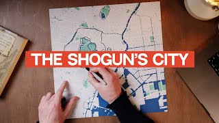
where do you get your paper maps. i would like one of my city
Oooo do Casablanca next please🇲🇦
I am Spanish and Catalan and I learned more about our history in this video than in school.
Amazing! Love that.
Bro q Coi, algú mes de Barcelona mirant aquest vídeo i aprenent més q al putu cole?
3. The big roman city walls (there are a previous ones, smaller and with less towers) are well dated in the final decades of the third century.
Rivers are switched in 1:00': Besos is east; Llobregat west -.-
Please do a cape town city map explained
Love Cape Town! We'll add it to the list!
the names of the rivers are changed 0:57
0:57 This graphic broke my brain for a second: you've labelled the rivers wrong! ;)
Nice video! Shame this channel does not get more views...
Subscribe and share 😊