Video není dostupné.
Omlouváme se.
Autel EVO Mission Planning Tutorial

Vložit
- čas přidán 15. 08. 2024
- Our latest firmware update introduces Mission Planning to the EVO through the Autel Explorer app. Join Alejandro from our customer service team an learn more about the functions of Mission Planning and how to get it set up.
Learn more at:
www.AutelDrone...
--
Autel Robotics is based outside Seattle, WA with best in class 7-days-a-week customer support. Follow Autel on social media:
/ autelrobotics
/ auteldrones


Keep the firmware updates coming. One to consider is altitude adjustment as you would climb so the EVO would follow.
Yes
YES PLS!
Yes!!!
Yes
And what I love about this is that it's David vs Goliath.
I hope autel robotics finds the metaphorical sling within!
This is pretty cool. I just purchased my first Evo. Looking forward to trying this. Please, Please, keep the software moving forward and evolving. Autel appears to have a great platform with the Evo. I look forward to many enjoyable flights. Thanks and be safe
Great news Autel Robotics! I had the choice to invest in the DJI Mavic 2 Pro, I selected the Evo because I see Autel excel in a better and stronger future in drone development. Keep up to progress of success. Rolando
Another home run by Autel Robotics. Nice work. Look forward to mapping with the Evo!
Autel, a lot of people ask for waypoints with soft curve and soft descend/ascend towards next waypoint....No answer...at least have a common sense and reply to all this people...this is a professional way to act....
Good tutorial, but for the non-commercial user, like me, not sure how often or why I would use this feature. In addition, it seems like you have to purchase a third party software application to use it effectively. I would hope that Autel considers improving its existing intelligent flight modes, such as Waypoints, to make it on par with Litchi or Parrot's Flight Planner or the recently enhanced waypoints in the DJIGO4 app. The Evo has a great camera, now make it more effective for the photo and video enthusiasts.
Yes you’re right . I hope autel will not do it for the next evo2 .
Not sure this will reach anyone at Autel but I hope it does. There is one CRUCIAL thing missing in the mission planner for aerial photogrammetry. We NEED to have control over aperture and shutter priority modes to lock them as needed. On very dark, cloudy days if flying at 100'AGL we need to be able to lock the shutter at 1/200th when flying over dark objects. With only auto it could drop below that speed and introduce motion blur. Similarly, if we are flying a roadway with a lot of tree cover a f/2.8 with a missfocus on the tree tops could cause the road far below to blur out. Being able to lock the aperture higher would help prevent depth of field problems with that scenario. I do appreciate the ability to control the speed which is a sort of work around for now but for legit aerial mapping we need more control over that sweet Evo II pro 1" sensor please. I say all this as the Remote Sensing Manager for our survey company, a Certified Photogrammetrist and Mapping Scientist and Pix4D Ambassador with 12+ yrs of aerial mapping experience from planes to now drones. Thank you! PS - Love the Evo II! - Just needs a few more software tweaks before it is a true DJI killer for aerial mapping. Also - who do I need to buy beers for there to get a global shutter on the Evo III?
You guys are absolutely number #1 I love my EVO it takes amazing video as well as pictures thanks for the remarkable technology guys keep it coming 👍
Just want to say THANK YOU. As a certified photogrammetrist so nice to see a viable competitor to DJI for aerial mapping. Would have loved a global shutter but can't have everything I guess. Please keep updating the mission planning side of Explorer.
Hiya, do you have a free Software you would recommend for this? Or is there an industry standard Software like e.g. Word/Adobe? What would you recommend... Just found out today that my Autel can do this and want to test it out :)
Ninja.vom.Wolfstor pix4d. Google it.
Any solution to the ground following being non-existent? With big changes in terrain elevation, you'd want this to keep the GSD consistent, right? Thank you for any advice you may have!
@@TLTPhotography what do you think?
@@tomthomsen11 Sorry - lost track of this - Evo II is now just a backup for us as we have moved on to a fleet of Mavic 3E for our company which have super reliable and smooth terrain following.
Add more options. We want different flight paths. Adjustable heights throughout the misson, option on camera heading direction. The options need to be broadened
What is the point of the 98 foot minimum height restriction?? This seems rather arbitrary. I need to use it much lower than this, for example flying slowly at low altitude while doing a hyper lapse. Sometimes I want to fly smoothly on a set path at say 20 feet. Can't do it with this. We are not all farmers just doing surveys of our property!
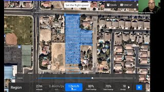
I noticed that when you change altitude it is not affecting the spacing of the flight lines. As the altitude increases the camera footprint will increase, meaning that with higher altitude there would be a greater spacing between flight lines while maintaining the same side overlap.
where I find the program to get the results after doing the mission thanks
You need to have a front overlap ratio and how many cm per pixel readout depending on what height you are at for precise 3d mapping.
GREAT!! AWESOME!! So glad you guys finally finished this upgrade! I think I’ve been your biggest critic on here about actually having the 3D capability you touted when I purchased my EVO last August. Seeing the demo mission you created is a bit confusing... why would you create a mission over a building... only to move that mission over to an open field? Then, seeing how the EVO doesn’t follow the actual mission route on the corners and just curved back to the next leg is going to mess up the final imagery on the edges. The fix in planning is to extend your mission grid out to cover these in a straight line path but is there a fix coming to clean up the flight path tracking to actually turn every corner? Thanks again for releasing this update...I’m updating mine this morning!
Absolutely. A most important feature if you want to capture the "mapping" market.
The tutorials are very good,they should be done in Spanish
for Autel Evo 2 users speaking hispanic
Los tutoriales son muy buenos,deben hacerse en español
para los usuarios del Autel Evo 2 de habla hispana
Hopefully you will be able to pre plan on a mac or PC as well?
Ok, this is going to a long question, please bear with me and answer the best you can. I have downloaded the latest Firmware, 1.5.8. While being disconnected to the Evo and since you aren't able to pre-plan a Waypoints Mission (when clicking on CAMERA) I went to CAMERA and there is a Waypoint Mission. I tapped on Waypoint Mission then I pulled up the location map I wanted to take pictures of. I carefully set up the Waypoints with speed and height to each point. I have a total of 20 waypoints. At the end of the Mission, I have selected the Evo to RTH. My question is: I don't see any screen showing directions on controlling the YAW L&R using the sticks? I able to manually adjust the gimble and shoot continuous video adjusting the spinning L&R of the EVO during this mission or is it only for taking pictures? Will this work?
Is there a way for me to have my camera at a different angle other than 90 while doing a rectangle, oblique, etc mission? When capturing solar panels, you want to have the camera angle the same as the solar panels for better clarity and detail. Your "competitor" has this function. This would be a major selling point!! Please suggest this to the big wigs if you haven't already...This would be a SUPER plus for Dual 640R owners like myself!!! Thanks in advance from Hawaii!!
I don't truly have a use for this feature. I've asked 1,000 times so here comes number 1001. When will waypoints be fixed so that it does not stop, it roses or descends gradually and it turns smoothly with no stops? That is a feature every owner could and would use.
I agree - just take a look at what Litchi or Parrot's Flight Plan can do - puts Autel's basic waypoint flight mode to shame. Cannot believe that Autel does not have POI's in their waypoint mode.
@@tjbc9794 3DR Solo was doing t right way before litchi ever heard of the feature. 😎
I feel your pain bud... I was like you for MONTHS asking for this new mission planning for 3D capability and got NO answers. You spend a TON of money on a drone and what seems to be a simple fix takes forever but I will say, patience is a virtue. They will not answer you about anything... only release stuff when completed. There are issues I see with this one now but at least we got something to work with as they refine it. Keep looking!
@@hispeed69 I still love my Evo as the picture and video quality our of camera is outstanding. But it has been 13 months today since I have owned my Evo and waypoints are no better today than they were 13 months ago today. That is a serious oversight on their part.
That's awesome and make the job more easy and give me an extra tool. Thanks guys awesome work
Good tutorial. Flew mission today but had question on resolution settings. I wanted highest. I did not check my settings first, I;ll do so on next flight. VR is now working with the mission updates !!!!
Last time I used a mission planning option was on my DJI Phantom 3. Never realized the pumpkin nor the evo did not have the same feature because I only used it once or twice on the DJI just to try it. But this looks like I may incorporate this feature going forward! I am really impressed with this drone, it flies so differently than anything else I have flown. Could we have other basic shapes possibly? AR is still my ONLY goto drone.
How do you delete a mission?
Why only Square/Rectangle Routes..? Please provide Routes that are other Shapes 'Please'...
You should do an update of this video and relate it to the Smart Controller V3
Can the Evo shoot video when executing a pre-planned “Mission” or only trigger time-lapse still photos? If it CAN shoot video whilst executing a Mission, can it take stills simultaneously? If I start filming video then execute a mission with programmed time lapse stills, will it do both or stop shooting video?
Can I use the evo2 for terrain mapping ???
Can i plan a mission on a hillside? How do I get elevation into the way points?
EVO 1
After creating offline waypoint mission, it shows up in mission history, but when connected it does not show up. Any help please?
I am having the same issue. Did you ever figure it out???
@@HBJones65 I was creating way points under the EVO 2, it wasn't as noticeable prior to the evo 2 updated way point screens.
@@ChuckBradfordPhotography Aha! Thank you so very much. That was my same mistake, too. All good, now. Thanks again.
@@HBJones65 cool, I was so bummed when it didn't work at first, glad I could help.
Does the altitude selection setting keep a relatively consistent AGL distance? Mission Planner and UGSC both pull elevation data from google to make sure the drones don't crash into the ground. I am looking at surveying a hillside that has ~100m height change over the total distance, however, I only want to fly 50m AGL.
Do you happen to support any other mission planning software (Pix4d capture, mission planner, UGSC)?
Is there any way to revert back to V1.1.0 on my evo1? Thank you. Please respond.
Going to be an amazing tool for Search and Rescue! But would like to slow it down to 1MPH or slower. Slow is smooth, smooth is fast. Keep it up all!
Hi Alejandro, I have been working with the mission planner for a while now, and no matter what I do, I cannot get the camera to look forward in the direction of flight. It is always skewed to the side and very frustrating. How do I remedy this? Also, if I am flying a rout with several waypoints, the transition from one waypoint to the next is not smooth. The drone stops for a second, then quickly turns to point in the direction for the next leg of the trip and so on. It does not make for smooth direction changing transitions. I tried changing the direction setting many waypoints, but but the process is the same. Pause, quickly adjust to the new direction and start again. Mane waypoints makes things worse. Also the direction of the camera remains skewed. Any advice? Cheers, Mark
Cool videos! Is there one for the waypoint mission planner that you mentioned in this video at 3:06?
It's now practically 2021. When, WHEN is Autel going to update their tutorials ? ? DJI has Autel beat in this regard by a long shot ! !
I am Autel EVO 2 8k User. Which 3d mapping software is suitable for Autel EVO 2.
Alejandro necesito programar kml, me podria ayudar ? gracias
How do you have the date and time stamp on the photos? I don’t have that and can’t see a way to set it.
Autel, please respond. Where would we find the exif data?
So, since you released the SDK, does this mean that I would be able to use their apps to do mission planning on my EVO? Or, do you also think that Autel will integrate what other developers create into the official EVO mission planning app?
Can you import a Google Earth KML into the Explorer Mission Planner?
Any limit on resolution setting when flying mission ?
Thank you,sir
A quick question regarding overlap settings
Surely at a higher altitude/height above ground, there will be a greater overlap due to the camera taking in a larger area. This should then mean that in something like a polygon or grid mission, the higher we set the altitude, the more space there should be between the legs of the flight.
This does not appear to be the case.
Given that the angle/field of view of the camera is known, surely the Autel Explorer mission planner can be updated to take this into account. Seems like this could be worked out with some basic trigonometry to determine the dimensions of the photo at surface, and this could be used to determine the distance between the opposing legs of the flight based on the number selected by the user.
Also, is it possible for the Autel Explorer app (for Evo) to also be updated to all the frequency of time lapse photos to be set to work according to not just a side overlap, but also a desired overlap with the next photo? i.e. something like it appears to allow for Evo II
Any feedback on this please?
Yes, this right here. It's so frustrating to see the evo 2 have this and not the evo. I mean, this isn't really an advanced feature or anything and it should have been in there from day one. At 350 ft and 70% over lap, the evo 2 still has a wider path than the evo 1 at 350 ft and 10% overlap. I don't understand how that got f'd up. It's like the overlap is stuck at 100 ft or something.
So it’s not just my imagination then.
I didn’t even think to try selecting EVO II, which works exactly as it should.
Strange how EVO I doesn’t work the same way
I really hope it’s updated at some point in the near future
@@bobcoughlan929 So another update rolled out. Still no fix. I called Autel awhile back and it kinda caught the guy off guard. He realized what we were talking about and said that I was right. He also said that he "thinks it's because the evo 1 doesn't have enough processing power" and that it's not a programming error. To me that seems wierd because I feel like it would be the app doing the math and figuring out what exact route it should be flying with however much overlap there should be. Idk, it just doesn't make sense to me. He said he would follow up but he and I both forgot apparently. I'm going to call them back in a few days and to be honest I think you should too. The more people calling them with the same problem the better.
Cool feature, not sure I would use it, when are you going to do a tutorial on the boat mode, all I have seen is YT'ers, no official guide.
Still missing Terrain following.
Any more news on the app when is it coming
when autel evo 2 fly mission planning can sensing obstacles?
It doesn't already do this??
Hi I Just bought one. Wondering how do you find out if the autel is up to date?
Turn everything on with your phone attached and wait a few minutes. After it fully links a Notice on the bottom of your phone screen will ONLY pop up IF you need to update. To speed things up, only update when you are on a WiFi connection. Make sure you do the update for all your batteries. Read your destructions carefully and you won’t have any issues. Good Luck.
@@hispeed69 thanks
Gostei muito,se a empresa quizer podemos divulgar esse trabalho com drone
Hola Alejandro tu eres hispano todos lo hispanos necesitamos la app en español
Waypoints is useless with the Evo. In fact, it's waypoints that is making me keep a DJI drone in my fleet. Waypoints allows me to get smooth, cinematic shots. But the stoopid way the drone stops, raises or lowers to the next altitude, then proceeds is stupid. Did Autel farm out programing this feature to a class of 2nd graders?
When are you going to come out with FPV goggles
I've been using the Glyph's via the Autel EVO but need a HDMI Tablet connected to the EVO Controller in order to Connect the Glyph to the EVO Controller.
@@DrStephenVerdon Which tablet do you use? I have Glyphs also. I've been puzzling over this for some time. It seems like a simple USB to HDMI dongle should do the trick instead of having to route through a tablet. Has ANYONE done this?
@@moodberry Hello Doug, The Glyph connects to the k1 via HDMI and duplicates the EVO Controller Display. I've tried using two other Tablets that won't accept the Glyph Goggles and found Fred's Glyph CZcams Video that helped me to Solve this Compatibility Problem. Thanks to Fred, I'm Good to Go. Look up Fred's Video... Cheers from Costa Rica
@@DrStephenVerdon understood. But I do believe it could be even simpler than the K1. BTW, I'll be in Costa Rica at the end of August, near punta arenas. RU located near there?
@@moodberry 1.5 hrs south. BTW: Simple isn't always the Best Choice. Cheers
The Mission screen thinks I'm hundreds of miles from where I actually am. Nothing wrong with my phone's GPS, other apps show me at the correct location.
Are you using a VPN on your phone?
Good for the EVO, but I feel this feature of the app need to more meat for full commercial use.
Then pay the 3rd party for those features. This is only a get started point as explained in the beginning of the video.
Field Audit Services And yes I will pay for it. Don't get me wrong I want to see Autel soar cause I trust my EVO and as a customer im just offering feedback constructively.
Vamos falar de tecnologia eu adoro,Já pensaram num celular comum se transformando num drone de reconhecimento,Temos tecnologia pra isso tornar o aparelho mais leve para que tenha controle total do sistema,sim temos avanço testes com materiais resistentes e leves,e só uma ideia que precisa ser desenvolvida eu não estou falando que tenho o material.e só uma ideia que esta na minha cabeça
Terrain Following!!!!!
In my case I need to fly up in the air to plan the way I want my shots programmed !
Damn. Autel is looking pretty capable.
Who's DJI?
Yo tengo un evo aposté por el
They need to add slower speed selections. 2 mph is too fast for smooth time lapse. The video always comes out jerky without extensive post editing.
Por favor español
I like my Evo, and am happy to step away from DJI, but I find this waypoint to be totally useless. I used waypoints with my DJI drones to get smooth cinematic shots. I could smoothly go up and over a tree or something, and the camera would point where I wanted throughout the hole flight. Not allowing me to be able to set the nose position, and the fact that it raises to the next waypoint height, then goes to that point is stupid. But thanks for the tutorial.
You find it useless, so they should scrap it... :D How about if other people need this? :D I certainly like to document the new building of our house with this... use it for photogrammetry... or to make meshes of our house... so we can easily see what has been done each day. I find it extremely useful
@@NinjavomWolfstor I never said they should scrap it. In my opinion, and everyone I've ever heard talk about it except you, the inability to change altitude as it goes from point a to point b, and the inability to set the orientation at each point makes it a 'feature' that isn't a feature really. With DJI you can get some great cinematic shots using waypoints. If I'm on a job that requires video, I'm almost always pulling my phantom out.
@@1QKGLH When I first got my EVO you would create a mission as you flew. You navigated to a location and selected that as a waypoint. You could change altitude and select that as another waypoint. When you saved it you got a text file with the extension "waypoint", which you could later tweak with notepad. Apparently that's history. I want to start at the base of a large tree, slowly ascend, and when I get above the top slowly tilt the camera down as I approach the center of the tree.
We are Videographers and not in to mapping, Dodo ! What we need is pre-planned movement and camera shooting what and how we need the shot, is that too hard to understand ?
Without jerky smooth movements that needs slower speed like 2, 3, 4, 5 ,6, miles per hour drone speed and user selectable delayed camera movement at the beginning and ending say 2, 3, 4, 5, 6, 7, 8 seconds delay.
Wake up Autel or refund our money or else hire DJI smart engineers to help you and fire your drunk engineers ! !
You sound horriable can't even understand at times, can't they let someone with crystal clear sound talk, dont rush for we need to take the information in.
Horriable sound quality, very hard to understand being a senior citizen.
Is there an Orbital Mission Planning option? I do not see one in the App under Mission. If not how does one obtain a smooth orbital map of an object?