Map Projections Overview and How They Distort the Earth

Vložit
- čas přidán 30. 04. 2023
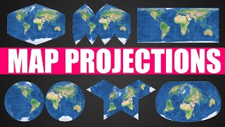
- Overview of many different types of map projections, how they came to be, and what each one may be used for. I discuss the general characteristics as well as looking at specific projections to determine which ones are the best and worst.
If you would like to purchase a pin for the viewer wall map or just to support the channel, please visit patreon.com/geographyking
Website to compare sizes of countries and states:
www.thetruesize.com/
Album displayed:
Robert Cray - "Strong Persuader" (1986)


I love that your videos are interesting enough in themselves that you don't need super fancy background music, transitions, intros, etc. Your content is just so good.
Thank you!
And no stock video clips!
Big ditto - please never add that nonsense!
@@Ozmodiar6 well to be fair I did use about 5 seconds of stock footage to show a globe being projected above a screen, but I'm not really a fan of stock footage and rarely use it. I do often use drone footage for showing cities. But that's about as exciting as it's gonna get.
@@GeographyKing I did notice that, haha. But some other CZcamsrs really go heavy on stock clips. It’s so distracting, to me.
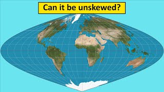
I'd like to point out that technically speaking there is no such thing as "an entire Mercator projection", as you mention at 3:34. This is because- as you move closer to the poles- things become increasingly stretched by a factor that approaches infinity, which means an infinitely high map in the absence of some cutoff.
My favorite one is the equirectangular projection.
The armidillo map "Doesn't leave anything off the map"
New Zealand, "Do I even exist?"
He definitely said that on purpose
Dude I absolutely love all your videos, particularly your videos about US geography are very interesting to me as I live in Switzerland. You've been one of my favorite content creators for a while now, keep up the good work :)
Thank you! I really appreciate that
“The Lord is not slow in keeping his promise, as some understand slowness. Instead he is patient with you, not wanting anyone to perish, but everyone to come to repentance.”
2 Peter 3:9 NIV
ROMANS 10:9-11 “If you declare with your mouth, “Jesus is Lord,” and believe in your heart that God raised him from the dead, you will be saved. For it is with your heart that you believe and are justified, and it is with your mouth that you profess your faith and are saved. As Scripture says, “Anyone who believes in him will never be put to shame”
Matthew 11:28-30 “Come to me, all you who are weary and burdened, and I will give you rest. Take my yoke upon you and learn from me, for I am gentle and humble in heart, and you will find rest for your souls. For my yoke is easy and my burden is light.”
“For the Son of Man came to seek and to save the lost.””
Luke 19:10
God wants us to believe in His One and Only Son, Jesus Christ our Lord and Savior, who died for our sins :D When we truly believe in our hearts that Jesus is the Son of God, who died for our sins so we could have eternal life with God, we are saved from the eternal fire and have eternal life in Christ Jesus!! 💖 May God bless you all! 🕊❤️
@blue person Sir, this is a comments section
@@blueperson77 Take your religion crap and go elsewhere.
The reason your videos are good is because you are passionate about what you do. I originally found this channel after I was quite sick a few months ago. I'm normally a joyful and engaged person but after my illness I experienced relatively severe anhedonia, which is the inability to enjoy things. I listened to your channel when I was commuting for work and just hearing someone talk about something they really enjoy helped me claw my way out of that. It was a really odd experience but I just wanted to let you know about what happened since I thought you might find it interesting, as it is a bit of a different way that your channel helped someone out. Keep doing what you're doing.
Thank you very much. It makes me happy that you've found the channel and have found it useful and helpful. That's really all a creator can ask for. I'll try to keep it up.
I've had a wall map in my house for the past 30+ years, and my kids grew up with a large map always on the wall in the breakfast area. Most days, someone was looking at the map for some reason. The past 10yrs, it's been a Winkel Tripel projection, which was the best large map I could get at the time; I've yet to find a better map for general use.
My undergrad Intro to Geography class used the Goode's atlas as one of the texts, so the Goode Homolosine is pretty familiar to me. The Armadillo projection does indeed leave a few things out: New Zealand, Antarctica, the South Pacific islands, and Southern Chile/Argentina.
Our kids grew up the same way. We've had a(n approximately) 7'x4' Robinson projection in the dining area since 1995. It was the subject of many conversations, including how it's now out of date (no Timor L'Este, no South Sudan, etc). It's still the subject of conversation, now including the grandchildren. It's funny, but if two adult family members are visiting at the same time but for some reason a bit angry with one another, and they find themselves eating at the table at the same time, they will both sit in silence, staring at the map . . . until one of them breaks the silence (and ends the spat) by saying, "Have you ever noticed that . . . ?"
@@BS-vx8dg Love that. Our meal conversations would often revolve around what was happening in the world. Kids would ask, "Where's [that]?" I'd say, "If only we had a device to discover the answer..." I don't think we ever went a day w/o someone staring at the map at some point.
Now, of course, there's Worldle and Statele...two of my kids and I play them every day. We're in 3 different states, and text our results to each other.
"Equirectangular Doesn't have any practical uses" My heart literally. It has ALL the practical uses. 1 degree= 1 (insert unit for size of map). I use it for everything. As a bonus, it also doesn't look half bad.
Thank you for mentioning the practical uses of the Mercator projection when it comes to navigation. Some people seem to treat it as if it was intentionally created to fool people. That said, I much prefer the Robinson projection when it comes to teaching and studying geography.
Many believe it is politically motivated to show northern countries as big. Ironically they project their own political views. Gall-Peters was created for political reasons. I recall someone blaming in a discussion Google for using Mercator and said they should use Gall- Peters. Others tried to explain how it would be useless for purposes Google maps is used, to view local maps. The world map is only for selecting the are. With Gall-Peters everything away from the 45th parallel would be distorted. He did not get it he was full of Mercator is racist propaganda.
Lots of people have naver used map with Compass
One of my favorite "true sizes" is Chile. All of South America is much bigger than it looks, but if you drag Chile up to the US, it shoots up past the Arctic circle and looks downright terrifying
Equirectangular is my favourite because it's so easy to deal with, lines of Lat and Lon are just displayed as-is, and it doesn't look too egregious
Hey! 200+K. Congratulations! Well deserved, Kyle!
8:05 nice burn :)
I'm a bit of a fan of the Waterman Butterfly Projection, myself, but I get that it's not the most aesthetically pleasing map. Fun video, no matter how you slice it.
I like the nod to Robert Cray's "Strong Persuader" there in the background.
I had to relisten at 3:29 to be sure you said comical versus conical. 😁
11:24 and one nice thing about this project and is that it doesn't leave anything off the map.
New Zealand: ummm...
Thanks for walking through those Kyle enjoyed them very much! Love the Robert Cray album too.
Should be required knowledge for everyone! So many people do not understand the basic concept of projections and how maps lie without this context.
You really do a fantastic job. It super fun when you're just candid and honest about your opinion. Always worth the watch.
Thank you! I've been looking for a good video explaining different map projections thoroughly and you did a great job!
Thanks for all the examples and descriptions!
Another banger. Great video Kyle!!
Great content King!
Took me a while to get to watch this, but wow! Even in my Geography classes, I never got such a clear overview of all the projections, nor how they were developed. This was great! Thanks, Kyle!!
More nerdery please!, solid content made by a man who does not underestimate his audience.
I love your channel! Geography has been a special interest my whole life.
Thank you! I'm glad you found the channel and enjoy the videos
great stuff Kyle!
Great video! Very interesting topic! I enjoyed watching!
Really great job...very impressive explanation
I always learn so much from your videos. Thank you fo making geography interesting
Good video with relevant information and senseful conclusion.
one of your best! many thanks!!
As a GIS tech turned Engineer tech, I had to learn this in college three times lol
You know your stuff, Kyle. Great video. Cheers
Hello fellow Chattanoogan, great video again. I was always a fan of the map they have on the United Nations building in nyc. Always thought it was a unique perspective. All of those projections were very neat. Thanks for sharing!
Good job on the projections Kyle. You are a strong persuader🙂.
THANK YOU
MR. GEOGRAPHY KING,
FINALLY A RATIONAL FOR THE MENY NOT SO GOOD MAPS OUT THERE.
MUCH APPRECIATED.
C&E*Ca.USA.
Thanks for the explanation.
This was one of my favorite things to study in university and I used to practice hand drawing projections at the map room. Not very practical but a lot of frustrating fun to learn.
Thanks, this was a great breakdown. I've always wondered about some of the crazier maps. Though I've always hated the Mercator, I didn't know what the best alternatives were.
I knew a little about map projections, but not much apparently. Thanks.
Great video!
I personally really like the Hammer projection, it looks as good as it gets imo
This was a really fascinating video, Kyle. Thanks for all the research, and an excellent presentation!
Very well done!
Great video.
You're brilliant. Thanks.
There exists a conformal version of the dymaxion btw, made pretty recently too i think since the math was so complicated. It is as far as i’m aware the least area distorting conformal map possible. I personally quite like the compact miller projection for rectangular maps, and the Gott-Wagner for curved ones. I just think they’re neat :)
I like the Natural Earth II projection the best. Most balanced compromise imo, basically an improved Robinson.
Excellent
Jolly good show.
I like the Dymaxion map because it shows the connections between continents.
All the various projections are evidence that the earth isn't flat. If the earth were actually flat, one "projection" would work much better than all the rest.
after seeing so many people throughout the years bash the mercator without making any mention of other projections, this video was a breath of fresh air.
(i still have a hard time believing, though, that that many people genuinely think greenland and africa are the same size--unless of course they've never seen a globe before.)
I never heard of any of these projections except for the Mercader one.
I kind of like the 'orange peel' the best. The Pacific Ocean looks too big on the equal earth. Or maybe it really is that big! Thank you - I've always liked maps.
6:56 Hey! My name is Werner, and I love apples! Too cool.
Totally unrelated: one of your previous videos about mustard made me a mustard need
I wanted to learn about this for game development purposes. Didn't learn anything i can use, but I enjoyed it anyway. 😄
Fine nerdy video!
Yeah
Happy to hear Geography King also hates the Mercator projection. Robinson and it’s descendants are the best.
I think having distortions that are much more familiar to us is really important. Like distortions that are similar to real world visual phenomena and distortions make it so our brains are more able to correct for it automatically. For example we sort of understand how things can distort on a sphere or a rounded surface so we automatically do a bit of correction in our head when looking at maps that are distorted in similar ways. But with the Mercator projection for example, it doesn’t really have any real world distortion counterparts that work like it at all so we don’t even notice the distortion if we don’t know it is there, and have a much harder time mentally correcting for it in our understanding. Obvious this is for the purpose of an interior I’ve “understanding” of the globe but doesn’t really apply to specific practical or scientific/mathematical purposes.
Hello, my name is Tyler, and I like leaning about geography from a nerdy perspective... (Group: Hello Tyler). Geography Nerds Anonymous.
Not at all surprised that you avoided any mention of the politics surrounding the Gall-Peters. You're a wise man, Kyle.
i guess im gunna have to take the time to use that app that shows the outline of each country drag each one to the equater . take a screen shot of each group as they sit on the equater print the screen shots cut each one out and stick them first on the table then on a same scale ball .
geezzz
not too confusing, but as this is a multiphasic topic - nice
I think the Robinson is the best general purpose world map.
My personal favorite is the Goode's broken homolosine. Yeah, it's an interrupted type, but from all I can see it has the least distortion.
Anyway, I studied a lot of geography in college and its a fave subject of
Addendum: I agree with you
On both Mercator and Gall-peters
Eckert IV is my favorite projection.
Look up the Natural Earth II projection, and see if that's still your favorite.
The Robinson projection for presenting the whole world. Case closed for me. 🌎 🌍
Try the natural earth ii projection, even better
thanks kye...interesting...i have a map taped to my kitchen wall..lehman brothers global telecom research team///
mercater type..it cuts off the poles...i like it.
ALL HAIL THE GEOGRAPHY KING 👑
Was it ABC News that always used the Goode Homolosine map in the background during the 1970s and 1980s? One of those networks did, at least.
Can't remember that one.
NBC in the early 80s had the globe spinning the wrong way. They eventually fixed it.
Kavrayskiy VII is my personal favorite
What are your thoughts on the Eckert IV projection?
Too funny, I have that exact same globe at the beginning and mine has the exact same problem, it naturally lays on it's side.
I've had it for about 20 years and it's never really rested properly
The Armadillo projection "doesn't leave anything off the map"? So where are Antarctica, the east coast of Australia, New Zealand and the Pacific Islands?
I've heard that you can make a peel from a globe lie flat if you make proper cuts at the top and bottom. It wouldn't be very useful when trying to map a route across one of the cuts (nor naturally across the east and west ends), but otherwise it would be a perfect 2D projection. Is there any truth to that?
You've heard wrong; it could never be completely flat. Each cut you make would it appear flatter and flatter, but it could never get all the way there.
If you take a program like Google Earth, which has the entire globe with everything being correct, what kind of projection do you then end up with when you zoom into a local area?
hi kyle, its keren and anna from germany/ uk/ israel, we told u some weeks ago we ll go on a 3 months us roadtrip, did already 6000 mi and tuesday/ wednesday we ll stay in chattanooga, maybe we ll c u somewhere 😊
Sounds like an amazing trip. I hope it continues to go well!
I love you
A lot of people strongly believe that the Mercator projection is fundamentally bad and imperialist, and that's how it got so widespread. I don't quite buy this (I think its main popularity is related to its being good for navigating the central Atlantic and Pacific, and its convenient rectangular shape). While it does indeed distort the northern and southern ends of the world quite a lot, it's worth remembering (as you point out) that all the projections distort *some* part of the globe.
I have a large Robinson projection in my home. F Mercator.
King
Use the Gleason's Standard Map Of The World. Azimuthal equidistant projection
Robert Cray
Since the earth is a sphere (basically) we could put the top of the world anywhere. What would it look like if, say, Florida was at the north pole. How would that globe's projection look?
Sounds like a good idea for a website.
@@BS-vx8dg there is one you can center the AE projection on any place on Earth, haven't visited it in years... but, it's out there. :)
Winkel-Tripel is the best, especially being Canadian, there are lots of maps that just squeeze it so small, it's ridiculous. Then some maps will name every state and Capital, then just Every country and their Capital. There is enough room in places like Russia or China to do Provinces even.
Armadillo - "Doesnt leave anything off the map." ......Angry New Zealander noises intensify
Is there any reason in particular you left out the azimuthal equidistant projection? (It's used by the UN on their flag, so I figured it was a shoe-in for inclusion. 😂
He included it.. 1:49
It's simply a lot easier to tuck a Rand McNally Road Atlas in the pouch behind your seat. A globe would hurt your spine.
Yo what's up Kyle
The Mercator / Gall-Peters section made me want to watch the West Wing again… 😂
Hemisphere in a square, not to be confused with jack in a box.
What about UTM zone maps? What do they preserve?
Mercator maps, either standard or transverse, are conformal to preserve shape.
@@GeographyKing Inside a UTM zone, aren’t distance and area also very accurate?
00:49 *comprise
No Peirce quincuncial projection? It's the best map of all time.
This is why I belong to the flat earth society. Keep it simple. Don't stray too far with your ship , because, you know, Sea Serpents and all...
I have that same gemstone globe. Love that thing!
This video is a hoax. I just wanted to throw the round-Earth people a bone. Obvs the planet is flat.
😵💫
I really hate the Mercator projection.
3:35 You cannot see the entire Mercator projection as the poles would be infinitely far away.7:03 The Werner projection shows nicely the relative orientation of North America and Russia. Traditional maps show it poorly. On the other hand Australia is badly distorted. Equal Earth is IMO the best general projection. It preserves shape well and preserving area is important in a world where people push Gall-Peters. They can reject any non-equal area map outright. It was deliberately created to counter the awful Gall-Peters.
Regarding the Armadillo projection not leaving anything off the map: New Zealanders might respectfully disagree.
Edit: You did mention that it's only 3/4 of the globe, so . . . now I'm even more confused. 🤔😉
It's kind of an inside joke with geographers about world maps often leaving New Zealand off. You could do a search for "Maps without New Zealand" and you'll get a bunch of hits. It'll probably auto fill it before you can type it all.
see dymaxion map by bucky fuller
The best map projection is a globe
stop maps at all
You'd need a pretty big globe to get any detail.
The sphere is not locally isomorphic to the plane
Doesn't leave anything off the map. Antarctica left the room.