Meander Evolution Simulation

Vložit
- čas přidán 19. 04. 2021
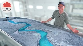
- This video utilizes the Emriver Em2 Stream Table to demonstrate meander evolution in a simulated alluvial river. One of the meander bends is armored with riprap to protect a home while other bends are free to migrate in response to the river’s flow. This video shows how meanders will change through time and demonstrates some of the unintended consequences of the “hard” approach to stabilizing river banks. Approximately 20 minutes lapsed during the simulation.
Suggestions for educators:
Before watching the video with your students, it might be a good idea to review some of the key terms used in the video. Feel free to direct students to www.ausableriver.org/programs... for definitions of these key terms:
Cut Bank
Eddy
Meander
Meander neck
Meander cutoff (also see Chute cutoff)
Riprap
Spring sapping
Questions to consider:
How did the riprap affect erosion on the meander bend? Upstream and downstream of the riprap?
How did the bend with riprap behave differently than the natural bend?
The slope or steepness of a river channel is equal to the change in elevation divided by distance. Water moves at a higher velocity and has more energy to move sediment in rivers with steep slopes. Explain why a meandering channel has lower energy than a straight channel flowing through the same valley. - Věda a technologie


That rip rap really comin in clutch, huh
Rip rap may stabilize a portion of a river bank, but it creates further damage downstream. There are better and more natural ways to restore and protect a river bank, including when human infrastructure is at risk. Learn more here: www.ausableriver.org/programs/restoration
@@ausablecentermakes sense... thanks
@@ausablecenter Wouldn't it be better if the riprap extended along the full length of the curve, ie from one straight to the next, rather than as placed? I understand this is for educational purposes, I'm just wondering.
@@nicotti Imagine a real river, stretching for miles
@@nicotti For a portion of it. But I think the bend after the riprap ends would be hit fairly hard and erode much faster
And when me and my friends did this in the back yard when I was ten my parents called it "making a mess" and sent me to my room.
This makes me mad. Kid's gotta experiment, man. How's we supposed to learn the science stuff elsewise? >:p Feckin books? Screw books. I wanna build a thing, and watch it systemically alter itself over time based on fundamental laws!
@@Woodledude But that is just a waste of time if someone else has already done it and wrote their observations into a book. :P
@@Quotenwagnerianer I feel like that's a rather naieve view of science. To a certain degree it's true; you can accomplish a lot more by trusting the experts in the field to be generally correct and have a pretty good grasp on things, but science is ultimately about thinking critically and asking questions, and believing you can answer them.
You build a much more intuitive understanding of a science when you're active in asking question in that field, and when you're just starting out with science, it is deeply informative and relatively straightforward to repeat experiments that have already been done, to come to your own conclusions based on those experiments, and so on.
So I'm going to disagree with the sentiment you put forward. It's not a waste of time. Hell, replication studies are a huge part of scientific rigor that don't get nearly enough love; why should we discourage participation in the way you're suggesting? What does that really gain us? Fewer scientists, less question, less rigor, more biased assumptions made by a minority of people that happened to be the first to study a problem and therefore became the "experts".
It is not a waste of time to study something that's already been thoroughly studied, because there is always more to learn. It is not a waste of time to tread ground that's already been tread, because until you tread that ground, you won't know what it feels like to do that, why people have made the decisions they've made.
I cannot agree with the naieve assumption that science should be "left to scientists", because otherwise there will be no new scientists.
That's my two cents anyway :p
@@Woodledude Half the joy in science is learning something, and later doing an experiment, any experiment, and going 'ohhh... so *thats* how that works out.'. used to spend entire days playing around in a local stream, come back muddy and sandy. but happy. would still do that if I wouldn't be looked at judgingly now I'm 20 years older XD
@gyrergd That makes me thing and imagine parents as a river, wonder where the rip rap is?....
I have no idea what half these words mean but I just think it’s neat
Haha you can check out some of the words here: www.ausableriver.org/programs/glossary
@@ausablecenter thank you :D
@Boco Corwin I think the word he may have used was riffraff.
Thank God for riprap
I can imagine a bunch of people the ausable river association sitting around drinking tea and talking about rip-rafts and meanders and spring sappings.
You forgot about the eddies
@@yadai4188 - I bet they're making fun of people called Eddie.
me watching the entire time: Come on meandering stream, daddy wants to see an oxbow lake
I'm playing Minecraft and this is what pops up in recommended...needless to say I'm intrigued
Recommended videos are the best!
@@ausablecenter and after, I continued to watch more videos of these simulations
@@ausablecenter this is oddly soothing
This was in my recommended because I've watched one of these live, and then have watched a couple videos like this, and one of a guy just unclogging street drainage
word
"Riprap is keeping the meander from migrating" sounds like a plumbus commercial
Riprap: "We ask for nothing, Master. "
Meanderfurter: "And you shall receive it. In abundance!"
LOL, the R&M army is everywhere.
hahahaha! nice
So does "Eddies form upstream of the riprap"
Why is this so strangely interesting? I’m gonna go watch more videos of how rivers work.
This is not how rivers work. This is how a sand model of a river works.
@@foodforthesoul1326 Except that this is how rivers work. A sand model works the same except it speeds up the developments. Where this took a few hours a real life river will take decades/centuries
I know you're here to help people know how to stop rivers from ruining places and stuff, but please do more videos like this.
I think the entertainment value of it alone will catch people's attention which would help spread awareness much faster than most other methods.
I've love to see a time lapse of how a river naturally forms from a water source.
Also, making a big mountain and seeing how long it takes to erode away and collapse would be epic. uwu
Why does it need to have an UwU at the end
@@w_ldan What _doesn't_ need an UwU at the end?
@@bernadettavarley exactly uwu
@@cancercentral9997 yes uwu
lmfao- uwu
The fascinating part was that the bulk of the cut-through was done on the downstream side of the isthmus. Did not see that coming.
Of all the videos on youtube I chose this one to watch while I eat my meal. It was a good decision.
Wow, CZcams algorithm finally recommended something good! 👍 That’s a really nice example of meandering channels and how they evolve thru time. Did my MS thesis on a very closely related subject back 20 some years ago - used ModFlow to see if drainage ditches along a road would affect cutbank erosion (inconclusive). I like how your run clearly shows the effects of riprap, and the meander cutoff was great to see, though I’m surprised you didn’t require more time.
damn youtube algorithm be recommending me how rivers work, thank you
I never really knew much about this kinda stuff but watching these videos has taught me more than school ever did
Brings back memories of university... My lecturer had a bit of a speech impediment, so it was whrip whap in our class...
Having already seen a similar video, I was pleasantly surprised how good this video is. I like the addition of the riprap and the detailed explanations of particular events.
it is 2 am, what am I doing here instead of sleeping ?
I could watch these all day long
You just might want to do that.
I'm currently designing the map of a comic whose story I'm creating, these types of videos always help to give tales a bit more realism.
As a DM I agree...
It's really cool to see a simulation of how rivers meander in real time
This is fire bro keep posting
I love this kinda stuff
You know what youtube, this IS interesting to me and I WILL watch it, thank you!
Its amazing to see it happen at both scales. I saw that effect of the river eroding and getting one turn cut, making the stream go straight. I saw it using animations and images from google maps, and it was quite impressive, but seeing it happen in real time here is so much better.
I love these kind of videos!
Helped a lot to understand the consept.Thank you very much for the nice demonstration
I learnt about them in middle school geography class - really cool to see these things in action
Oxbow lakes are formed when the river's meander is too wibbly wibbly wobbly to maintain the course it's on.
This is the comment I was searching for.
Interesting, I've been getting your videos lately and I'm really liking it, thank you.
Very interesting indeed. I live in a havy meander area (lower Paraná) and it could be important to talk how these kind of river usually meander inside a "flood valley". Urban development tend to ignore this area and catastrophe comes knocking at your door when the "thin" and curvy stream becomes a straight and thick river, swallowing up all the banks.
No idea why videos like these are coming up in my recommended but dang do I enjoy them
This video is very neat, I wasn't aware that the erosion of soil via groundwater was called spring sapping. Thank you for the entertainment and valuable information! :)
Im wondering if its a term just used in relation to river meanderings or ground water in general
Mark my words, this is going viral
Excellent video, would love to see more of the stream table
CZcams:
Videos from channels I have been subbed to for years: Nope
Random video about topic I have never searched: Here you go
From a suppposed "scientist". LMFAO!
I should be asleep buuuuut when a recommendated video like this comes up, it catches my attention
Spring sapping... I just learned a new term. I loved "playing" with the stream table in high school.
I love how this exemplifies that the outside radius of a turn in most situations is where most of the energy tends to be applied to the media and where most of the wear and turbulence will occur.
Yes, it's a nice visual.
Very nice illustration.
This guy is very underrated
This is some pretty good meander evolution simulation ASMR.
things like this intrigue me so much and I have no clue why
When using riprap it should be extended around the bends and keyed in at stable locations in the banks. I wish I had the equipment to make cool simulations like this. Excellent information. Thank you.
wasn’t looking for this but it was fun to see
I'd love to have a table like this that I could just place a glass top on and watch how a model river evolves.
This is like an episode of interdimensional cable
Nature's pretty neat.
@@ausablecenter i really hope you understood the reference lol
@@DatDuckOfficial Haha we understood it a "little bits." ;-)
This is entertaining and informative.
this was really cool thank you 😌
Fascinating.
Wow what a great video
This is super cool. Can you do more videos like this? I love watching the way the river evolves!
Then watch a real river. This is bogus.
This is what I call COMMON SENSE
Great work
Fascinating
*in a monotone voice* "the house has collapsed into the river." Imagine all news anchors were like this
idk why but this is so cool
me :Watching
The guy:The house has fallen into the river
in lego city
Something that blows my mind is the scale. I kayak rivers in my free time and the one by my house has bends that exceed a 1/4 mile. The amount of erosion that happens on that scale is insane
Thanks for the suggestion CZcams. I'm not exactly sure why, but whatever I guess
I have a river near my house and I have seen a lot of these formations in it. It's not nearly as bendy but now I know how in some parts there are just these ledges and in others, "beaches" were created.
There are methods to help combat erosion induced structural collapse of housing and other buildings along river banks, but ultimately the water consumes all. It’s best to build a safe distance away from the water’s edge. That said, if you do build too close to the banks, and you _really_ want the building to last centuries down the line when the erosion eventually will be an issue to the foundations, place it on piles going into bedrock, and elevate the building well above the flood line.
Very intresting!
Ah man, if only the bypass happened sooner, the bottom house would have been spared...
What should I watch?
CZcams: yes
i feel like i could watch this for hours
Man gets to play in a sandbox all day
And the bypass’d meander becomes an Ox-Bow lake.
Funny how channel meander models have to start with the meanders.
What will happen eventually is the formation of a braided network with multiple meander channels of varying sizes, discharges and sinuosity.
Hi Andy,
Thanks for the comment. It can take a while for the meanders to develop naturally, so I think a lot of videos dig out the channel to speed up the process. In this case, I had a few hours to work with, so I formed a channel to start the model and let it run. Many factors affect the development of braided channels versus a meandering, single thread channel, including slope, sediment load, seasonal variability in discharge, etc.
It can be hard to translate exactly what's happening in this model to real-life. For instance, this is an alluvial channel model with no vegetation and hard, structural controls provided by the stainless steel basin where the sediment is contained. That's not exactly a scenario found in nature. The meanders can only migrate so far before they reach the edge of the table. However, I think there is some value in seeing how a meander changes through time. Cut banks will migrate outward, chute cutoffs will occur, oxbow lakes will form, etc. It's also interesting to observe the fluid dynamics at play within the channel, and the multi-colored sediment allows for that visualization. You can see the erosion due to higher velocities on the outer edge of the channel causing cantilever failures on the cut bank, and the deposition of sediment by slower currents at the inside edge. Thanks again for engaging with us on this.
@@ausablecenter we're always making models, but sometimes, a simple one (even if oversimplified for truly practical applications to be feaseable) can give greater understanding of a subject down the line. thank you for sharing this!
Would've been nice to see a reference to oxbow lakes at the very end, but given the angle you seem to have been working on (as well as the really permeable substrate) it wouldn't realy have been anything.
for a teaching aid, this would be quite usefull I think. sometimes you have to learn things that are somewhat wrong, so you can later go 'ah, it's not quite right. here's how we improve it' while learning and understanding more then you did before at every step of the way.
Nice!
"Riprap was placed on the cut of this meander bend"
Me, an intellectual: "Ah yes, of course."
You can’t just say words and expect everyone this was recommended to to understand!!
Great point! You can find a glossary for some of these terms here: www.ausableriver.org/programs/glossary. Thanks for the comment.
This was super helpful in helping me understand for a uni assignment! If the model was deeper with more sand under the rip rap, would it eventually undercut the rip rap & cause it to collapse?
This is a bit off topic but I believe that remnants of meander cutoffs have been observed on Mars which is another big reason to believe that water once flowed throughout the planet.
For the non-Earth Science peeps in the comments, basically the turning points of the water are cutbanks and are banks that are cut(no way lol). This is because erosion is higher here since water wants to continue to move straight(inertia) so most of the force is forward on these cutbanks.
In some cases if the cut off bend in the river doesn't dry up you get a little lake or pond with a bent shape. Translated from Swedish they're called sausage lakes. :D
Super interesting, great video!
Somehow I think it's noticeable that the starting state of the model is artificial, i.e artificially narrow river and so on. But we have to start somewhere.
4:47
OXBOW LAKES ARE FORMED WHEN A RIVERS MEANDER-
God bless the algorithm. See you folks in a few years!
This is how one of the lakes in my city was made cool
Who else watched the entire video just to hear Riprap one more time?
Hey, so that’s how oxbow lakes form! That’s neat!
Yes indeed!
Luckily there's more than just sand holding most land masses together.
"And that son is why we live in a houseboat"
Its cool seeing rivers with a bunch of oxbows and knowing this happened.
it's too short! I want to see what will happen next
Maybe we'll make another video!
And that's how oxbow lakes are formed (called billabongs in Australia).
I don't know if it's considered rip rap, but I've seen rivers and creeks in Oklahoma where farmers had placed old cars, tires, and other junk into the banks to prevent erosion (mostly so they didn't lose land for farming etc.) Kind of interesting when you run across those things.
Hmm, interesting. So, a question or so.... The wave formation of the river channel when you start is high amplitude, and short wave cycle. I remember flying into Winnipeg and seeing the river that runs through it, and it was similar to your model, except that the shape was more like that folded ribbon candy where the long sides of the wave almost touched, and the arc of the curve was very wide. I am thinking that this is a more common shape in rivers that flow through very flat land, and the more hilly the area is, the shorter the wave length is and the shorter the amplitude of the wave is. Correct, or is some thing else going on. Oh, in flat land, water flow rates would be much slower than in steeper areas, and I don't know if that would just slow the erosion process down in the flat lands but end up with a similar shape and process...
You're correct that when a river's slope is low, meanders tend to form and erode the landscape laterally. This creates wide, flat valley bottoms with the "folded ribbon candy" shape that you're describing. Over time, those long sides of the wave will narrow the meander neck, and a cutoff will form, like the one in the video. Steeper channels have very low sinuosity and erode their landscapes vertically, creating deep, narrow V-shaped valleys.
Imagine playing a survival game, building your house on a riverside because it looks nice, then finding it one day just in the water
Hats off
Thank you!
Reminds me of Shrewsbury in the UK
There was the 50 minute stream ecology lecture on rifles pool run sequences distilled into five minutes
I really like these demonstrations, can anyone point me into the direction of more videos like these?
Emriver straight channel simulation
: czcams.com/video/vLpLYBzssWI/video.html
this reminds me - in south moravia was flood like 9 years ago, it took bunch of homes and gas station because they were too near of river.. and they built right back only for flood two years to take that gas station again.. so they built it back
I swear to god if I hear riprap one more god damn time 😂
how was this erosion table built, and are there directions available? and how did you keep sand from piling up at the bottom of the table?
It's an Emriver table, they have an extensive website for their products!
I do have a few questions: I know it would mostly depend on the local area but how long would this particular outcome take on average? Would adding more ripraps increase erosion speed downstream?
You can see detailed answers to this first question in comments below. Yes, adding more riprap would increase erosion speed downstream.
Shoutout to the first aid kit.
I know of a missing link in the education of geologists. They tell us that our planet Earth has the most to fear from an asteroid impact or volcano eruptions. But when we look at the many horizontal layers that we find everywhere on our planet, we clearly see the effect of a repeating cataclysm. These disasters are mentioned in ancient books like the Mahabharata from India and the Popol Vuh from the Mayans and others. They tell us about a cycle of seven disasters that separate the eras from the world. Certainly, regularly recurring global disasters cannot be caused by asteroid impacts or volcanic eruptions. The only possible cause is another celestial body, a planet, orbiting our sun in an eccentric orbit. Then it is close to the sun for a short period and after the crossing at a very high speed it disappears into the universe for a long time. Planet 9 exists, but it seems invisible. These disasters cause a huge tidal wave of seawater that washes over land "above the highest mountains." At the end it covers the earth with a layer of wet mud, a mixture of sand, clay, lime, fossils of marine and terrestrial animals and small and larger meteorites. Forests that existed are flattened and because of the pressure from the layers on top the wood is changed into coal. These disasters also create a cycle of civilizations. To learn much more about the recurring flood cycle, the re-creation of civilizations and its chronology and ancient high technology, read the e-book: "Planet 9 = Nibiru". It can be read on any computer, tablet or smartphone. Search: invisible nibiru 9
So you better watch out when your upstream neighbor builds a riprap.