Cross Country Flight Planning Step by Step | Nav Log Example Part 1 | FlightInsight

Vložit
- čas přidán 30. 07. 2024
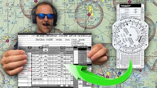
- Cross Country flight planning for your private pilot training requires you to complete a Nav Log. You'll need to get information from a few different sources, bring it together, and calculate headings, time enroute, fuel burn, and more in order to plan a safe flight. Here we'll walk through step by step how to complete the Nav Log for an example flight from our home airport in College Park, MD (KCGS) to Hagerstown.
Download a blank copy of this excel navlog here! www.flight-insight.com/post/u...
Complete your training with online ground school! Visit flightinsight.teachable.com/p...
Chapters:
0:00 Materials Needed
3:19 Determine Route of Flight
9:25 Choose Checkpoints
15:30 Determine Altitudes
18:40 VOR Navigation
22:41 Get Winds Aloft
26:07 Calculate True Airspeeds
33:53 True Course
35:14 Wind Correction Angle and Groundspeed
41:33 True Heading, Variation, and Magnetic Heading
42:47 Deviation and Compass Heading
44:34 Distances
46:14 Time Enroute
Cross Country Flight Planning Step by Step | Nav Log Example Part 1 | FlightInsight


Two new videos each week! Subscribe Now to stay updated! czcams.com/channels/AHvg_6KCB3MgOY_PvNZCDQ.html
This is by far the most concise yet thorough and simple to follow cross country flight planning CZcams I have come across. Thank you thank you thank you!
Great video. I’m a PPL student about to commence my nav training, and I found this really informative. Thank you.
Very helpful and easy to follow. Obviously, your Excel sheet might do some of the calcluations automatically, but it's probably a good idea to show your students how these calculations work before they use automated tools. Thank you very much for sharing this publicly.
Good job. I really enjoyed this. It's been some time since I've flown, and this was an excellent refresher for me. It was especially nice that you went from start to finish and used the old e6b. That was another part I found really interesting and helpful.
Thanks, Steve. Happy flying!
The nav log and E6B is not difficult, but, new students need someone to take it point by point and show " how to's" ...... Amazing job.... Great help.... Thanks..
this is a great video, you deserve more likes than 997. I am about to do my XC, this video is so good and easy to understand (for the most part. I need time to digest the TAS , TH,WCA)
I really appreciate the link to the navlog, probably one of the best I've seen.
You covered quite a bit of info succinctly and quickly. Fantastic review of XC fundamental planning. Thank you.
Among the plethora of videos on youtube, your channel is just GOLD. I'm a new student just starting my flying and so wish you were somewhere close to get some lessons in person. Your teaching style is just amazing and the learning goes from 0 to 100 in no time.
This was so amazing. Thank you much for the fantastic content. I am doing my cross country flight this week. My cfi has only worked with me on flying the airplane and no ground work so I am doing it all on my own. My trip is going to be KMVN to KPCD(anyone want to plan it for fun?😃. I feel confident about planning it after watching this video.
New pilot training for my ppl currently this took soooooooooo much confusion out of it thanks appreciate start to finish
That was the best explanation I've seen demonstrated. Easy to follow and well done!!!
Agreed. Literally the best. This helped me plan mine and I had zero ground lessons from my cfi. I was doing it all on my own. when I showed up with my x country my cfi was blown away. he said it was the best he's ever seen and took a copy of the log forms for his own use. This channel is the best out there.
very easy to follow. This really helped
THis is super helpful, thank you so much. It's nice to see that youre using the same sectional as me. I fly out of Frederick.
Very good. If it is not for your exam though, you can round things up conservatively to concentrate more on the general outcome, a specially on a short flight like this one. A small correction: first leg CH should be 013 (MH - DEV).
Thanks for the good points. Yes in the real world we might not spend all this time on each flight and concentrate on, as you say, the final outcome. I’ve always had specific questions about the nav log so wanted a full tutorial for those who might be hung up on one or two points.
@@flightinsight9111 You're absolutely right, students should learn the full concept first, before the application in real life. Automated flight plans should therefor always be checked for this final outcome to be acceptable. Thanks for your response.
Just completed my x country flight today. My cfi said that I was the most prepared and organized student he's ever had after using your nav log and preparation. He even asked for a blank copy for his use. This video was so much help. Thanks a million for all of your contents.
Thanks! About to do my first cross country here in Tacoma, WA.
Awesome! I'm sure that's beautiful flying up there
same
THANK YOU !!!! BEST
great video very detailed.
this was awesome, thanks
great video. good refresher. I tweaked mine a bit to compensate for TOD Top of Descent to pattern altitude, then added 10 minutes for fuel and time at pattern Ground Speed....just to be conservative. Remember the MAIN purpose of this exercise is to ensure you have enough fuel to get to your destination, fly the pattern, and land. Just curious...How to you address the descent to landing portion??
Great video ❤
yes thanks for the very step by step process.
You're most welcome. Happy flight planning!
Thanks!
Great video
You should have TOC, TOD. For time, fuel, helps pick a better cruise, and a lot of dead reckoning
Great idea. We don’t tend to use TOC around here with the Bravo but a video demo’ing TOC and TOD would work great. Thanks for watching!
A detail I hadn't caught before, climb perf in KIAS and cruise perf in KTAS. Of course, unless you're at high density altitude, KIAS ~ KTAS.
Best cross country video I have seen, I won’t name the other guy I watched but he make everything a fcking joke and this was straight to the point
Hello...LOVE your work!...where can I find the transparent Navigation Plotter to use in my own power point presentations?
Good stuff. I like that excel nav log
Is there somewhere I can download this nav log?
Thanks, glad you've enjoyed.
Matt, the navlog comes with the private pilot course linked here. If you like, I can send you a blank nav log file. Email me at my address in the about page (training@flight-insight.com)
You can now download a copy of the navlog here www.flight-insight.com/post/use-this-excel-vfr-navlog-to-organize-your-cross-country-flights
Can't wait to meet you
Great video! Thank you for sharing! You didn’t add TOC and TOD on check points section. Is that ok to skip those on my check ride x country flight planning?
Exactly, TOC and TOD should be planned and calculated on the Navlog.
You're awesome 😎
Very good information! Where did you get the e6b? I need more practice with it
Designed it on excel. You can grab one at www.flight-insight.com/post/use-this-excel-vfr-navlog-to-organize-your-cross-country-flights
Should the compass heading on the first leg have been 013 for a -2 degree dev?
Yeah that’s why he charging $100 😂
yes
Complete teacher
god bless you
I just follow the roads. If I get lost I just go low and read the signs. I carry a parachute for those times when I accidentally fly into a prohibited area and get shot down. Fortunately it doesn't happen very often.
For short time & distance the ' Seconds Index" should be used stead the " Speed Index" the resulting time will be given in sec. or min. on the inner scale .....
Hi on the KCGS part section HM / DEV You have 015 & -2 You then Added Them up to get 17 on your compass heading Should you have not taken it of ? im just starting off in this , but a real compass 2 dagreas woul make a big difrence over a longer time . so is headind 13 ?
after taking off the - 2 ? I would like to know so i can get things right thanks
I REALY enjoyed the video thanks :-)
You are 100% correct. I tried to call this out in the description but I wish I could edit the video to make it more obvious to you guys. Thanks for watching!
On the subject of measuring distance with your plotter.
I thought because of the variation in printing sectional charts you should only use the scales provided on the chart itself and because of temperature variations of the plastic measuring device. Can you clarify this?
I've never heard of this but just line your plotter up with the scale on the sectional... if they match then you can use the plotter. If they don't match then I would use the scale on the sectional.
Good video; however, TOC and TOD should be calculated and marked as a checkpoint in the Navlog and chart. 👍🏽
What if the TOC isn’t until after you clear the Bravo?
Hey really nice video and super useful content in general!! Non pilot here, but wouldn't it be handy to calculate the IAS as well since many aircraft only show you IAS during flight? And if not how is the TAS used? Do pilots calculate IAS in flight based on the actual conditions ? Thanks and cheers from Italy
Giacomo, indicated airspeed is converted to true airspeed based on density altitude, that is, the altitude the aircraft is flying at corrected for temperature and pressure. The E6B can be used for this calculation.
@@flightinsight9111first of all thanks for the answer ! I meant that in some aircrafts you only have an IAS indication inside the cockpit...so wouldn't it be better to write down the IAS (converted from TAS) as well in the log book? So that as it happens for CH you have a value that you can directly compare with your instruments. I did this in simulation flight and im wondering if it's something real pilots do...thanks again!
@@giacomoscomparin4937 Ah I got it. We need TAS so we can calculate groundspeed, and from that, our ETE and fuel burn. Many airspeed indicators will have a scale that you can read true airspeed off of in addition to indicated airspeed
@@flightinsight9111 ok got it ! Thanks !
Hi nice video. Where I can get the excel nav log.
What if my flight route doesn't have any prominent VOR nearby? What should I do to determine the wind direction and velocity?
TAS calculation: Standard Temp @ 6000MSL is 15-(6x2)=3C. The reported temp @ 6000'MSL is 12C. so .. 20 degrees below standard temp at 6000'MSL would be 3-20= -17C. 20 degrees above standard temp at 6000'MSL would be 3+20=23C. Since 12C is closer to 3C (only 9C difference). Its the closest of the three possible choices. IE. 20 degrees below the standard would be a difference between +12C and -17C which is equal to 28 degrees difference. Whereas 20 degrees above the standard temp would be a difference between +12C and +23C which is equal to a 11C difference.
cant you just intercept the 325 radial and fly it to and from? back it up with the ground points
If true airspeed during a climb is 76 knots, don't you need to consider the angle of climb to know the ground speed?
Since the title of this video says Part 1, where would I find Part 2?
Nice detailed video.. For years I was so excited to learn aviation but the more I learn and videos I watch the more cumbersen and less appealing it is becoming. I realize it's for ours and the public safty but its seems like there has got to be a way to simplify the whole process . I'm beginning to think that driving would be quicker. BY the time you do a pre trip inspection on the plane, mess around with all the chart weather and all the calculations, drive to the airport you would probably have 3 hours before you even leave the ground. Is all the planning work and exspence worth the reward. ??
Hey! Don’t let all the nitty gritty discourage you. This exercise, and really all of the training for the pilot license, is there to get you thinking about all the things that go into a flight. Once you’re flying on your own, the process is a whole lot smoother (you don’t have to do one of these for every flight!). Think of it as, you’ve got to learn the rules before you can bend them!
Very good to learn all the basics and the y behind it.
Part of the fun is the journey
Being a pilot isn't for everyone, just like being a nurse, musician, construction worker, engineer, etc., isn't for everyone. Admittedly, flying is the most challenging and fragile form of transportation, hence the complexity.
BUT, for those willing to take on the challenge and put the time, effort, and yes, money in, the rewards are absolutely worth it.
I'm a student pilot in my40s; almost done with everything needed to get my private license. My only regret is that I didn't start doing this in my 20s! It's been fun, exciting, frightening, and humbling. It's also been the best stress relief I've had in decades.
So what does being a pilot give you? The ultimate freedom. Go where you want, when you want, how you want.
If I've had a crappy day at work, I swing by the airport on my way home, hop in the plane, and watch the sharks, dolphins, other large fish, and watch the sunset before heading home with a big smile on my face. Very little planning is needed for this type of flying.
Two weeks ago my mother-in-law ended up in the emergency room. It would have been a 3.5 hour drive one-way, but was only a 40 minute flight. The FBO (airport terminals that private planes use) was only 1/2 mile from the hospital, and the FBO has free courtesy cars, which they pull right up next to the plane. No waiting.
Many of the skills required are like learning to tie your shoes or learning to ride a bike. Very difficult at first, but as time goes on it becomes second nature. I've not timed my pre-flights lately, but I'm guessing it's under 10 minutes, possibly under 5 minutes. Planning, as seen in this video, is the long-way to do it, to make sure students understand exactly what is going on. They've gone into great detail here, (over)explaining each single step to make sure students comprehend the process. There aren't road signs or pit-stops in the skies, so it's important to get it right. At the same time, GPS has been a godsend and makes the process so much simpler than this for normal flights. It's still a good idea to know how to do thing "the old fashioned way". GPS occasionally doesn't work, iPads overheat, and aircraft electrical systems fail. That's when knowing the old-school paper-chart methods are good.
I think that one has to realize that we are not birds. Flying is not a natural thing to do, that means that when (not if) something happens out of left field, a lot of decisions and necessary information is already gathered and thought through. If one would take the habit of simply jumping in their plane and taxi without preparations, it would spell disaster sooner or later.
Just quickly looking at the navlog, there is no TOC or TOD. Why isn't this included?
Where do I find the compass deviation card? I know that they are located in the aircraft but is it standard information that can be found in the POH or all they each individually different?
typically the mechanic that installs or maintains the compass will have created the card, so it's aircraft specific
It will not be in the POH, or any other document; you generally find it as a placard attached to, or near the compass.
Wait so I don't understand how is the 75 knot figure an IAS when the chart says it's KTAS?
The chart does not state TAS, it states KIAS.
How do we calculate TOC?
Why don't you just calculate ETE with the calculator instead the E6-B ? Leg distance / GS x 60. Ways more accurate and also quicker.
Coffee at 18:40
Where do you find the names of the check points-airports? Is there a book somewhere with that info?
Do you mean the names that I gave the checkpoints like I-95 or Olney? It's up to you you can use Google Maps for town names or other landmarks. For the airports, you can read them right off the sectional chart.
@@flightinsight9111 oh ok. thanks
@@billziegler9634 Of course, hope that helps!
@@flightinsight9111 I think so. I am not a pilot so it's all very complicated to me. Nor can
I be because of a disability.
@@billziegler9634 Even without flying, I think these subjects make for a great education. I wish I could have learned some of this stuff while I was in grade school, I'd have a much better understanding of things like physics and weather. Good on you that you're interested. Have you played around with Vatsim or any of the other flight simulators?
Where is Top of Cliimb and Top of Descent?
I enjoy your channel, and this is not a criticism, but there are a lot of aircraft out there that have any of those fancy manuals or performance charts. Throw us a bone and explain how this is done without the fancy charts. Thanks.
how do you get the plotter to apear
I just had a picture of a plotter that I edited into the video. I don't have a way to use it outside of that.
@@flightinsight9111 ok cool
Where can I get a copy of this file?
No fuel burn calculation ?!
Seems like the most important part of this flight was skipped. Need ATC clearance and given unique squawk code flying out of DC lest you wanna be shot out of the sky.
yeah can add 10 or 15 minutes of fuel and time to compensate for unforseen ATC vectors. Good point.
You do not include top of climb and to of descent
I am not sure why this is still having to be learned. With technology, once your check ride is over you will not use this format again.
Many DPEs allow foreflight in the checkride now , but you have to be ready for them to simulate the iPad “failing” now too
But not allowing jt is completely backwards, you should be learning how you’re going to operate , and for about 99% of pilots it’s about leveraging tech and foreflight is almost a must have
Very poorly explained TAS density calculation, been trying to understand where you got what you did for an hour now
volume goes up and down - annoying
Do you not have a volume adjustment?
Cross country? You're in the state of Maryland and haven't left..😂
14 march 2022. Updated link for the E6-B simulator:
mediafiles.aero.und.edu/aero.und.edu/aviation/trainers/e6b/?q=sliderule