3D Mapping and Navigation using Octrees on a Quadrotor

Vložit
- čas přidán 9. 09. 2013
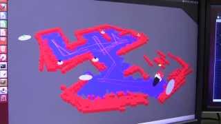
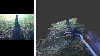
- The project aimed to demonstrate a novel technique to create dense 3D maps of an environment using a quadrotor. Our approach was to map the environment using a planar hukoyu laser range finder mounted below the flying quadrotor and have the quadrotor yaw continuously to capture the entire environment. The map was stored using an Oct-Tree which enable compressed storage and allowed 3D navigation through the space.
- Věda a technologie


Thank you for the very clear description of what an oct-tree is... just what I wanted to know.
BTW - amazing work with the quadrotor.
Its always nice to see computer vision/ robotics implement things that are commonly used in video games. I've actually done something very similar to this to fly drones in a game though the world octree data is computed/ optimized beforehand rather than at run time goals were also not set based on visual data but rather points in 3d space. Similar idea tho, and cool usage :D
Good job on developing technology
Brilliant!
Amazing!!! Can you tell me Which sensors did you use in the quadrotor?
How did you guys construct the 3D Mapping with the data ??
Great work, a qq though, why not use computer vision instead?
Where can i get this tech? plz answer.
The diagrams and visualization offer an excellent non-technical explanation of your mapping algorithm. What level of computing power is required on the vehicle?
+rjnuckolls There is an embedded processor onboard, but some global estimation is done off- board on a laptop. All real time processing is done on the embedded system though
How well could this stuff be used for mapping the Fukushima plants?
Well it could potentially be used, but this quadrotor has some limitations like battery life which could not be suitable for long missions
wery nase your warking
sooper your brain sir
so you were the wizards who mad the Phantom 4 magic?
Could you please tell me the name of this research paper? Is the simulation source code available for download?
+Khuong Nguyen . Part of this was a class project. For more information about maav check out maavumich.org/. Source code is probably not available for download. But the code was build using april robotics toolkit april.eecs.umich.edu/wiki/index.php/Main_Page
Don't you have a Github link for the code?
BURGERLER BOTS