How To Efficiently Create Site Topography | ArchiCAD Beginner Tutorial

Vložit
- čas přidán 13. 02. 2023
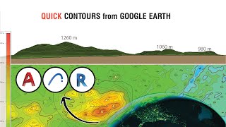
- This video demonstrate how to efficiently design a site's topography so that it will appear neat and presentable in both 3D and 2D information for site plan drawings. If you watch the entire video, I show you how to use the materials I produced for you to improve the quality of your site plan drawings and many other tips and tricks for the mesh tool. If you're just starting, I understand that this could seem intimidating, but don't worry-this is the appropriate video for you.
🟠Project Files; rb.gy/hcmfdl
🔵ArchiCAD Resources: msbim.store/
🟡MSBIM ArchiCAD Pro Template: rb.gy/iec0i
✅ Join Our Community WhatsApp Group:
chat.whatsapp.com/Bl7sMuiMtQ2…
To receive a new video notification every alternate Tuesday and Thursday please subscribe and press the bell icon If you learned something from this video then please Like & Share - Jak na to + styl


Thank you for this. Well explained and the free files are a bonus. Much appreciated!
Very much beginner level. Amazing! Thank you very much. This is the tutorial I needed.
Great to hear from you
Absolutely love this
Thank you
Absolutely love it .❤️
Thanks for the feedback and Im glad you find it interesting
Excellent tutorial 👍🏽👍🏽
Thank you
Hi, I would just like to ask, don't we need to set the scale before merging our file or does that not matter? If the file we are working with was created on a 1:1 scale don't we need to match that scale on archicad before we merge that file? thank you
Download the 2D tree Plan Object Library used in this video: rb.gy/hcmfdl
hello, where do we can create dwg file for terrain? is there any specific website for it?
Hello sir? I have a project that am working on and it's too big. It's sitting on a parcel of land measuring 750m x 640m. Am challenged on designing a Master plan and have all the information of the layouts and road networks on the same page and print a visible drawing in pdf format. Any Assistance please, on how I can set my line weights, how to set my texts to be visible, and how to set the scale so that I may capture the whole information on 1 page and still have a visible drawing. I appreciate your assistance in advance sir
I am trying to get my file (my topographical view of my site) from Digimaps is there any requirement to select when extracting the file before merging into Archicad as I am struggling to open my file
What if there are different elevations within a grade line. For instance north portion of the line is 1000 but the south side of the site along the same line is 1120
In that case you will have to use cut and fill method
No possibility to insert pdf files