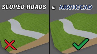
Realistic Roads in Slope Terrain ArchiCAD tutorial

Vložit
- čas přidán 7. 07. 2024
- 🟠Project Files; tinyurl.com/mxk6bvs6
🔵ArchiCAD Resources: msbim.store/
🟡MSBIM ArchiCAD Pro Template: rb.gy/iec0i
✅ Join Our Community WhatsApp Group:
chat.whatsapp.com/Bl7sMuiMtQ2...
🔹Download and Increase Your Productivity, Efficiency, Quality in ArchiCAD.
☑MSBIM 2021 ArchiCAD Template: gum.co/jSXVl
☑MSBIM 2021 ArchiCAD Template + Cost Estimating Pack: gum.co/vFPNr
☑VDC ArchiCAD Simplified Course + Template and Resource File: gum.co/JPUsS
☑100+ MSBIM ArchiCAD Door Collection Pack: tinyurl.com/255f86f3
☑Aluminium Window Pack | MSBIM ArchiCAD Virtual Library: tinyurl.com/yc8krefs
Subscribe for more!
Please Like this Video!
In this video, I show you how to model a realistic road with markings on slope terrain - Jak na to + styl


Give us your thoughts on this video and suggest and engage with us what type of video or topic should I cover for the next video. Thank you for contributing to this channel.
First is a question. Can you draw the road profile ( showing the layers) in archicad? Cover a topic on including road furnitures like kerbs or walk path or road signs
@@bensonwanjau9051 Thank you, I will do that
Great!
very helpful! Thank you!
🙏🏾
But the road profile is NOT orizzontal along lenght.
Is there a way to have a horizontal road profile along its entire length?
well done !!
Instead of dragging a copy before offsetting, you can press the ctrl key and it will create a copy as you offset
Thank you for that @Gu Schmidt .
What if you don't have the values
@@bensonwanjau9051 The values are coming from the site survey diagram. If your topo is level there is no need.. Maybe I don't understand your question, can you please clarify it. Thank you.
@@MesolightVisual thank you it's well answered. I expected an answer on level ground. Thanks
@@bensonwanjau9051 My pleasure
DID YOU CREATE THE CONTOUR LINES OR IT IS AN EXISTING LINE? THANKS FOR THE TUTORIAL
It's existing topography.
Nice tutorial, But I think you should have started the tutorial right from scratch- from the contour lines
I will consider that sir. Thank you 🙏
Hello, how did you go about obtaining the contour line data and importing it into Archicad
a bit cumbersome! Exhaustive in explanation. It would be interesting a tutorial on a horizontal road surface with ground fill side and the act of excavating the ground. A real road with a horizontal road plane and not referred to as meshes.