How to create contour map from XYZ Data in GIS

Vložit
- čas přidán 5. 09. 2024
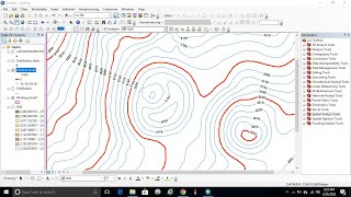
- In this tutorial, you will generate a contour map from X, Y, Z data using ArcGIS, Also you will be familiar with other applications to use gis as Interpolation making DEM file


Good. Keep it up.❤️👍
Thank you so much 💓👍
This great
Thank you so much
Kindly provide the link to download the data you're using, for practice
that is the link for the data,may be somewhat different but you can use it
docs.google.com/spreadsheets/d/13y-IM39gw_btFKANj-UlIlkq13B-uOqI/edit?usp=sharing&ouid=118098622700487615181&rtpof=true&sd=true
sir, plz attached the excel file for practice.
Sorry I don’t have the excel file, but this link can helps you to create your data
czcams.com/video/9YrRSfgOvzo/video.html
Please can i have of a sample xyz data
so sorry