
- 37
- 235 137
Elite & Afana
Registrace 26. 10. 2021
Welcome to Elite & Afana CZcams Channel. Hope everyone is well in this world pandemic. I have completed my Bachelor Degree in Civil Engineering and Master of Science for GIS in Environment & Development. If you're looking for a channel that combines with Civil Engineering & Geographic Information system Knowledge, you're in the perfect place. You can watch my video and if you find it helpful, please Like, Share my videos & Subscribe to my channel . I really need your support to inspire me and grow my channel. Thank you for being with me.
Paid Services:
I have professional Senior Design Engineer in Water Supply and Sewerage Pipe Network. I have provided Working drawing or Detailed drawing, As-built Drawing of any kind of Pipe line network with a GIS database.
If you want please feel free to contact with me.
Company Name: Eminent Engineering & Construction Co.
WeChat: Saifur_Elite
LinkedIn: www.linkedin.com/in/engr-saifur-rahman/
how to Import excel data into ArcGIS II Import XY Coordinate from excel to ArcMap
Importing Excel data into ArcGIS can be incredibly useful and time-saving, especially for users who are familiar with Excel and want to leverage their existing data for geospatial analysis. The process allows seamless integration of tabular data with geographic information, enabling powerful mapping, visualization, and spatial analysis.
The ease of importing Excel data into ArcGIS eliminates the need for manual data entry, reducing the chances of errors and improving overall data accuracy. Users can quickly bring in data, such as X, Y coordinates, attribute information, or any other relevant details, directly from their spreadsheets, without the need for complex data conversions.
By merging Excel data with ArcGIS, analysts and researchers can gain deeper insights by visualizing geographic patterns and relationships. The geospatial capabilities of ArcGIS allow users to create meaningful maps, perform spatial queries, identify trends, and conduct geospatial analyses based on the combined attributes and locations.
Furthermore, this streamlined process promotes data interoperability as it supports various file formats, including CSV and XLSX. It facilitates seamless data sharing between different software systems and departments, enhancing collaboration and communication within an organization.
In conclusion, the ease of importing Excel data into ArcGIS empowers users to take advantage of the geospatial capabilities of ArcGIS, unlocking the full potential of their data for better decision-making, spatial analysis, and meaningful visualization. Whether for urban planning, environmental analysis, business intelligence, or any other field that relies on geospatial data, this functionality enhances productivity and efficiency, making it an indispensable tool for GIS professionals and enthusiasts alike.
zhlédnutí: 693
Video


Creating Accurate Thiessen Polygons in ArcMap II Create Thiessen Polygon by using ArcMap
zhlédnutí 579Před rokem
Creating Thiessen polygons in ArcMap is a fundamental technique in spatial analysis and GIS mapping. In this video, I'll show you step-by-step through the process of creating accurate Thiessen polygons in ArcMap, using your own point data. We'll cover the basics of geoprocessing and spatial analysis, and show you how to use the powerful tools in ArcMap to generate accurate and visually appealin...

Google Map in AutoCad Civil 3D II Importing Google Maps in Civil 3D
zhlédnutí 4,6KPřed rokem
Google Maps in AutoCAD Civil 3D allows users to easily import high-quality satellite imagery, street maps, and terrain data directly into their Civil 3D projects, providing a powerful and versatile tool for project planning and design. In this Tutorial, I will show how to add Google Map in AutoCad Civil 3D. Similar Tags: #GoogleMaps integration in AutoCAD Civil 3D #ImportingGoogleMaps in Civil ...

Population Density Map || Comparative Population Density Map and Population Distribution Map
zhlédnutí 2,2KPřed 2 lety
In this video, You will learn How to prepare Comparative Population Density Map from the data of excel, How to join the attribute data in the ArcMap, calculate population density and prepare comparative population map. Data download link used in this video: drive.google.com/file/d/19nkp53OHf-FPYKpo4AZyc0aa9GGSbAE9/view?usp=sharing Hope you will enjoy this tutorial. Please Subscribe my Channel, ...

Topographic Roughness Index (TRI) in Arc GIS II Topographic Ruggedness Index using DEM in ArcGIS
zhlédnutí 933Před 2 lety
In this video, I am trying to show about Topographic Roughness Index (TRI) in ArcGIS TRI: To express the amount of elevation difference between adjacent cells of a DEM. The degree of changing topographic gradient between a channel and the stream adjacent hillside. The results are normally interpreted as follows: 0-80m is considered to represent a level terrain surface 81-116m represents a nearl...

How to Add Horizontal Legend in ArcMap ( How to Create Map in ArcGIS )
zhlédnutí 941Před 2 lety
In this video I will try to show you how to Add Horizontal Legend in ArcMap & how to Create Map in ArcGIS. Sometimes we have to create customize legends in many cases which most of us do not know how to do it. I think this video will help you to solve this problem. #horizontal_legend #lebel_in_arcmap #Elite&Afana
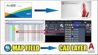
Converting GIS features into multiple AutoCAD layers based on attribute values (Field to CAD Layer)
zhlédnutí 7KPřed 2 lety
In this video, I am going to introduce some valuable tricks when converting the field data of the Attribute table as a Layer in the AutoCAD so that we can easily organize the objects in a drawing & reduce the visual complexity of a drawing and improve display performance by hiding information that you don't need to see at the moment. So, wait until the end of this video and get a better experie...
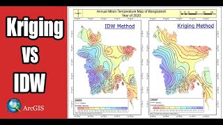
Interpolation method in arcgis II idw vs kriging interpolation, IDW vs Kriging , idw and kriging
zhlédnutí 3,7KPřed 2 lety
This tutorial is designed to introduce you to a basic set of interpolation techniques( Interpolation method in arcgis II idw vs kriging interpolation, IDW vs Kriging , idw and kriging ) and surface comparisons which is including: • Inverse Distance Weighting interpolation • Splines interpolation • Kriging interpolation In this video, you will learn how to estimates unknown values with help of k...

Calculate an area, length and other geometric properties in ArcMap
zhlédnutí 2,9KPřed 2 lety
In this tutorial, I'm going to show you, how to Calculate an area, length and other geometric properties in ArcMap. Share, Support, Subscribe!!! Subscribe Link: czcams.com/users/EliteAfana Follow on Facebook Page: eliteafana Follow on twitter: saifur_elite Follow on Instagram: saifur_rahman_elite Follow on Linkedin: www.linkedin.com/in/engr-saifur-rahman O...
Delete multiple fields from an attribute table at once in Arcgis II Delete multiple fields in arcmap
zhlédnutí 1,1KPřed 2 lety
In this video, I'll show you how to delete multiple fields from an attribute table at once in Arcgis II Delete multiple fields in ArcMap. Share, Support, Subscribe!!! Subscribe Link: czcams.com/users/EliteAfana Follow on Facebook Page: eliteafana Follow on twitter: saifur_elite Follow on Instagram: saifur_rahman_elite Follow on Linkedin: www.linkedin.com/i...
How to download High Resolution Topographic Maps by using Google Earth Pro
zhlédnutí 627Před 2 lety
In this tutorial, I will show you, how to download High Resolution Topographic Maps by using Google Earth Pro from the online topographic map collections sources of the University of Texas Libraries. To do this, we will also be making use of the Google Earth application, Basically, to view the availability of the topographical maps across the globe and pick the right one that we might potential...
Convert AutoCAD file into a Shapefile or Shapefile into AutoCad II convert Autocad dwg to shapefile.
zhlédnutí 23KPřed 2 lety
In this tutorial I'll try to show you, how to Convert AutoCAD file to a Shapefile or Shapefile to AutoCad II convert autocad dwg to shapefile. Share, Support, Subscribe!!! Subscribe Link: czcams.com/users/EliteAfana Follow on Facebook Page: eliteafana Follow on twitter: saifur_elite Follow on Instagram: saifur_rahman_elite Follow on Linkedin: www.linkedin....
How to change the projection of a raster in Arcmap II Project Raster in ArcGIS(Raster Projection)
zhlédnutí 1,3KPřed 2 lety
In this tutorial, I'm going to show you how to change the projection of a raster in Arcmap II Project Raster in ArcGIS(Raster Projection) Share, Support, Subscribe!!! Subscribe Link: czcams.com/users/EliteAfana Follow on Facebook Page: eliteafana Follow on twitter: saifur_elite Follow on Instagram: saifur_rahman_elite Follow on Linkedin: www.linkedin.com/i...
Download & Install QGIS Latest Version free for life time II How to install QGIS on windows 10
zhlédnutí 56KPřed 2 lety
Download & Install QGIS Latest Version free for life time II How to install QGIS on windows 10
Cinematic video making of maps by Google Earth Pro specially for use in travel, tour & news videos
zhlédnutí 780Před 2 lety
Cinematic video making of maps by Google Earth Pro specially for use in travel, tour & news videos
How to add Google Map in ArcMap as a Base Map II How to add Google Map Imagery in ArcMap as Base Map
zhlédnutí 10KPřed 2 lety
How to add Google Map in ArcMap as a Base Map II How to add Google Map Imagery in ArcMap as Base Map
How to download Geodatabase, Shapefile, Raster & KMZ for ArcGIS & Google Earth of any Country
zhlédnutí 880Před 2 lety
How to download Geodatabase, Shapefile, Raster & KMZ for ArcGIS & Google Earth of any Country
Dasymetric Mapping in arcgis II Dasymetric Mapping tutorial II Dasymetric map vs choropleth map
zhlédnutí 4,1KPřed 2 lety
Dasymetric Mapping in arcgis II Dasymetric Mapping tutorial II Dasymetric map vs choropleth map
Digitization in Google Earth Pro with 3D View II Digitization Google Earth Image
zhlédnutí 884Před 2 lety
Digitization in Google Earth Pro with 3D View II Digitization Google Earth Image
Creating and Sharing a Map Package in ArcGIS
zhlédnutí 8KPřed 2 lety
Creating and Sharing a Map Package in ArcGIS
Geoprocessing tools in ArcGIS II Dissolve,Intersect, Union,Clip,Buffer
zhlédnutí 8KPřed 2 lety
Geoprocessing tools in ArcGIS II Dissolve,Intersect, Union,Clip,Buffer
How to create boundary line shapefile from raster Image II Retrieve raster image to boundary polygon
zhlédnutí 7KPřed 2 lety
How to create boundary line shapefile from raster Image II Retrieve raster image to boundary polygon
How to Create 3D DEM from Topographic Survey point with ArcGIS & ArScene | DEM in 3D View in ArcGIS
zhlédnutí 2,2KPřed 2 lety
How to Create 3D DEM from Topographic Survey point with ArcGIS & ArScene | DEM in 3D View in ArcGIS
Flood vulnerability Mapping and Flood 3D simulation Modeling an area using ArcGIS in Bangla
zhlédnutí 3KPřed 2 lety
Flood vulnerability Mapping and Flood 3D simulation Modeling an area using ArcGIS in Bangla
How to Georeference a Google earth image in ArcMap
zhlédnutí 16KPřed 2 lety
How to Georeference a Google earth image in ArcMap
How to download climate data for Bangladesh
zhlédnutí 3,7KPřed 2 lety
How to download climate data for Bangladesh
How to download SRTM DEM from Open topography
zhlédnutí 7KPřed 2 lety
How to download SRTM DEM from Open topography
How to download shapefile free for any Country
zhlédnutí 2KPřed 2 lety
How to download shapefile free for any Country
How to do in qgis
Thanks!!
Thank you bro
Not helpful at all
Can you provide me dem file of nepal
hi can you use qgis in making this? badly needed a DEM for my thesis but i only have qgis
good work .thanks
Hooray!!! You helped me learn to send selected parts of a shapefile so I can share parts of my data with other entities!!!
That can also be used for a city?
My study area is Kolkata . so, where i get population data? can you help me , if you know about this ? can you share the website of population data of Kolkata .
en.m.wikipedia.org/wiki/Wards_of_Kolkata_Municipal_Corporation ....... this is my study area Kolkata. where i get actual population data
what is i don't have ArcGIS? you have to pay for it, right?
Hey , can u tell me how to insert that georefrencing to layers , i didn't understand this step
Scale thik rekhe kivbe export korbo cad e?
Type is too small and fuzzy. Moving fast thru menus makes it hard to follow. The very first step - what was that?
Is the licence is free ?
Yes
could we create atleast 10m DEM resolution from google earth?
what is the resolution of your generated DEM?
30m
Which software this one, Please really i want
anyone knows how to do it on QGis?
Thank you for sharing
how to find the additional file if it comes with map package??!!
sir, I followed your steps correctly but the Google map isn't showing up.
Sir can you please clip the population shape file and the area shape file along the video it would be helpful... Thank you ☺️
Thanks for the video. Can I have a later version 2.4 and 3.28 on the same system? Or I should uninstall 2.4 first before installing 3.28? Anyone can answer please
First uninstall previous one and installed newer one
Thank you!!
hi, can you give any reference on how to assign relative density weighted value of against land use. or reference for weight you have assigned for land use.
How can i get mouja map shapefiles of bangladesh
Hello Brother the tool seems to be very helpfull but its show unidentified error. I tried to add WMTS service from google maps or bing imagery, when I click GET LAYERS, show unidentified error. I have Arcgis 10.6
Send me your screen record please
@@EliteAfana I appreciate your interest and assistance with this error. I make this screen record : czcams.com/video/k1yTtVb2YV8/video.html
Bro gps visualiser website link bro
What resolution is the Google Earth DEM's? Is it possible to get anything close to 50cm-1m?
No
How many samples are required in squire km for IDW analysis in ground water standard analysis
very nice.
Thanks
Ty sòoooo much
Thanks
Hlo sir amr arcgis app ta open hoy na license not support bol6e ki krbo....
Buy a new license.
Informative video How to convert contour data to utm format?
Keep watching, I'll upload soon.
Hello brother its show unidentified error
Share screenshot with me plz
Have you got solution?
@@shubhak3850 nah bro now iam just using download images of latest google
would it be possible to do this without Arc map interference or a similar program. a program that do not need to be paid or something where you can do one down paiment?
You can create DEM by using different relevant program.
I am currently pursuing my Undergrad in Environmental Science, at Chittagong University. I have a course in GIS. I tried to make the contour map for so long but couldn't. Your Video helped me to create one. Thanks for the data and your guide. Can you please tell me why the shape files don't overlap even if they are in the same projection system? But with your data, it worked. How did that happen? Thanks again. And keep doing these kinds of tutorials more...
Thanks for your comments.
same
Nice ❤
Thanks
That was really helpful Bro, JazakAlla khair <3
My pleasure
Thank you for the tutorial! All the steps are very clear. How can I export the DEM data generated as a BIL file?
Thanks for comment
Can you upload the file you click in Add Base Map which is Imagery. Please for study purposes
Sorry dear, I don't have this file
Can you please explain me what is the prime difference between "Union" and "merge" function in ArcGIS?
I selected an area then submitted it,but the total size was only 8 mb !!!!
DEM have no relation with MB
nice video can i copy the link?
Yes, You can .
How download Srtmgl file.?... What kind of file this is.. Topographic elevation or water level?
Topographic Elevation
Sir mouza map ya jameen ka naksha ko satellite image per kaise set karte is per video banana
Ok I’ll try
lot of Thanks.
You are most welcome
Thanks for your sharing ❤
Thanks for watching!
thank you
My pleasure