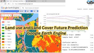
When convert it from raster to polygon then, then dissolve polygons on the base of grid code, after that you have Grid code such water having 1, vegetation having 2 so on, you just turn on editing form editor tab and select polygon click on attribute if it falls into another class assign / change it Grid Code; basically, this process is used increases the accuracy. thanks, have a good day! !


Great tutorial! Can the process you have described also be carried out using Landsat 7 data? I would appreciate your feedback. Thanks
Yes
Thanks @@GISsolutions
Sir i want to create lulc map of 2000 but landsat 8 image of that time is not there what should i do?
Use landsat 5
Thank u sir
First of all i want to thanks awayfully, i am very confused after making gridcode, so what next step should be follow,final step🙏🙏
When convert it from raster to polygon then, then dissolve polygons on the base of grid code, after that you have Grid code such water having 1, vegetation having 2 so on, you just turn on editing form editor tab and select polygon click on attribute if it falls into another class assign / change it Grid Code; basically, this process is used increases the accuracy. thanks, have a good day! !