How to Use Google Earth 3D-Scenery for your Fireworks Show? - FWsim Tutorial

Vložit
- čas přidán 10. 09. 2024
- FWsim Pro is a fireworks show planning and visualization tool. Download Free Trial: www.fwsim.com
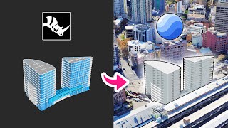
In this short tutorial we will introduce you to the Google Earth 3D feature which allows you to load any location into FWsim. Google already offers 3D models for thousands of cities, which we can integrate into our show planning.


Wow what a nice new feature!! I've been wanting to have a realistic background for my show/presentations. I'll try it
Gracias por el video! ya lo tengo todo aclarado!
You did a great update.
However, we are waiting for the real sounds of the effects of each individual firework.
This thing is really missing and we hope it arrives as soon as possible to make this sim unique.
Thanks for your feedback! The improvement of all sound effects is already on our list. We will do our best to work on the sounds asap. As you might can imagine, the recording of sounds is linked with huge challenges. We‘ll keep all of you up to date :)
J'ai un problème : je ne peut pas me mettre assez bas pour voir un monument, est ce normal ? Dans votre vidéo, on arrive à voir la montagne en face.
Thanks for your message. You mention that you cannot get the camera low enough. Which location are you using? Do you use the location from the video or another one?
Depuis que la fonctionnalité est sorti, je n’arrive toujours pas à le faire j’ai toujours du bleu
Hi, that might indicate that the coordinates are wrong. Please send us a message with your coordinates and we'll have a look! (You can send a message through the FWsim website)