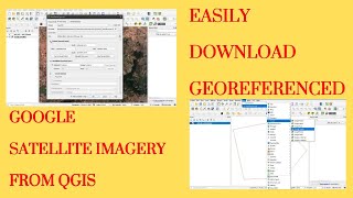
Create GeoPDFs in QGIS | GeoPDF in QGIS

Vložit
- čas přidán 26. 02. 2022
- A GeoPDF is a georeferenced PDF file, meaning that it is a Portable Document Format (PDF) file with added information that relates the image to coordinates on a map. GeoPDF files can be used as plain PDF files but have the added capability of some limited mapping functions (turn any map layers on and off, obtain XY coordinates for a location, measure length, and more).
Geospatial PDF is a set of geospatial extensions to the Portable Document Format (PDF) specification to include information that relates a region in the document page to a region in physical space - called georeferencing.
There are many uses for a geospatial PDF. After importing geospatial data into PDF, one can use the data in a variety of ways:
*Find and mark location coordinates.
*Measure distance, perimeter, and area.
*Change the coordinate system and measurement units.
*Copy location coordinates to the clipboard, and then use them to show locations in several web mapping services.
*Register a raster image to create a geospatially aware PDF.


I've seen another video on using geo referenced pdfs for maps. The other one (in french) was demonstrating viewing the geo pdf with acrobat reader and how you can turn the layers on and off and other things. In your description you note that geo pdfs from qgis have functions like toggling layers on and off. That is something I want to do in a standalone pdf file. I have exported a qgis project with a couple layers as a geo pdf and opened it with acrobat reader. I can see the overlaid images but don't see any controls to turn the layers on and off. I'm using qgis for linux so far. I will try again later with qgis for windows. Maybe it will behave differently. I'm also a little confused. I have installed acrobat reader but I also have acrobat pro on my windows system. I haven't used actual acrobat reader in a long time and this version has a lot of editing capabilities or so it seems. I don't know if maybe I wind up opening the file in acrobat pro or something either. Seems like I should be able to install both and use one of the other. Acrobat pro can use geo referened pdfs. I can see the layers with it, but to make it interactive so you can turn them on and off, etc you need to create javascripts to make the controls. If this is something I an do right from QGIS it would be a lot simpler.