SMCT: Identify Terrain Features on a Military Map

Vložit
- čas přidán 16. 01. 2019
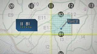
- A visualization depicting the Soldier’s Manual of Common Tasks (STP 21-1-SMCT) task Identify Terrain Features on a Military Map (071-COM-1001). This was developed for the Center for Initial Military Training, FT Eustis, Va. This visualization has been approved for public release.
Storyboard developed from the STP 21-1 Soldier's Manual of Common Tasks Warrior Skills Level 1, September 2017
Approved by the Center for Initial Military Training (CIMT) G-3/5/7, Initial Entry Training, Fort Eustis Virginia. - Krátké a kreslené filmy


So far this is the best terrain explanation video. Thanks!
Great quality video. Thank you so much!
Keep the Videos Coming!!!
the valley shown at 1:00 looks very much like the west side of the "Going to the Sun" highway in Glacier National park, Montana
Thank you.
Very educational!
Excellent ❤❤❤
Hidden Valley Ranch Salad Dressing. 5 major terrain features. DCS three minor.
Very good topic
Awesome!! class on Land Nav
CIT class if you know you know
Ok sir thanks
How does the fill lokk in the map then?
idk for certain but at 5:39 the ticks go inwards for cut and outward for fill (seen at the lower 1/3 of the map diagram)
2:38 you state the V-shape or U shape for a ridge always points towards higher ground. Other videos state that it always points downstream. So now i am confused!
Why, as I ask Myself ( as if I can answer Myself) , could I not comprehend Land Nav, both as a Marine and a Soldier, from 1987 to 1998, but here and now, as a 53 Year Old USMC and US Army Veteran ,in the midst of hostile Anti-American, Anti-Christian, Anti - Military Civilians, can I now understand Land Nav, Courtesy of The United States Army's TRADOC G2 OEC G&V Video Series?
It’s the videos you might be a visual learner
“Ridgeline”
Honda owners: 😊
“Real” Truck guys: 😑
Nice quilty video
explain mutual support
depth and domination also
1:07 hey I know that one
Mgys