What is Remote Sensing and GIS?

Vložit
- čas přidán 17. 06. 2024
- "Remote Sensing vs GIS" is something that everyone in the spatial science realm had pondered about at some point in their life. And it was nothing different for me when I started a couple of years back. Hence, as I am restarting this channel, I want to provide a brief introduction on what is remote sensing and GIS - and their major types, applications and a few key terms (such as active and passive remote sensing, shapefile, raster and vector data, ArcMap, GIS mapping, etc.). Even though there are a lot of similarities, they are both entirely different science streams (more like sister departments).
Understanding GIS and Remote Sensing will help you figure out the right technologies and approach you will have to adopt for solving your specific research questions - and, who knows, maybe even encourage you to consider any of these areas as a potential career path.
----------------- Contents of the Video -----------------
0:00 - Intro
1:30 - What is Remote Sensing
3:53 - Sensor Platforms and LiDAR
4:59 - Active and Passive Remote Sensing
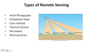
6:19 - Types of Remote Sensing
7:57 - Example Applications
8:54 - Issue with Excessive Data
10:00 - What is Geographic Information Systems (GIS)
12:03 - Data Collection, Management and Analysis
14:20 - Key Terms related to GIS
-------------------------------------------------------------------------
Hope you guys find this video useful. Leave me a comment if anything is unclear or if you would like me to go in-depth on any of the specifics. Thanks for watching! - Mikey
LiDAR Remote Sensing Playlist: • What is LiDAR? A Quick...
Intro to LiDAR: • What is LiDAR? A Quick...
Intro to Spaceborne LiDAR and NASA GEDI: • Spaceborne LiDAR and N...
3D GIS: desktop.arcgis.com/en/3d/ & www.esri.com/about/newsroom/a... - Věda a technologie


------------------ Contents of the Video ------------------
0:00 - Intro
1:30 - What is Remote Sensing
3:53 - Sensor Platforms and LiDAR
4:59 - Active and Passive Remote Sensing
6:19 - Types of Remote Sensing
7:57 - Example Applications
8:54 - Issue with Excessive Data
10:00 - What is Geographic Information Systems (GIS)
12:03 - Data Collection, Management and Analysis
14:20 - Key Terms related to GIS (shapefile, GIS mapping, ArcMap, etc.)
-------------------------------------------------------------------------
Hey man
is there is a way to contact you directly?
Refers to a computerised techinque of acquiring and manipulating geographical information without physical interactions.
Hey! Geoscientist and UAS Pilot here. There's a lack of channels in the field of Remote Sensing / Drones / Geospatial+ and I follow your channel with pleasure :)
Hey Margherita! Thank you for your support. Please feel free to comment on how I can improve my presentations as well. I am also just learning new things everyday. And I remember you. I had earlier connected with you in LinkedIn :) + Happy new year! 🎆
@@TheNomadicOwl hello plz
why connectivity of lines and polygons is an important component in OpenStreetMap?
Haii
Hi i m from pakistan i wanna learn gis and remote sensing and i need notes of gis if you have or if you have free time than kindly teach me gis
Hey Mr.pilot i have question for you, Does GIS well developing field?
Thankyou so much! Perfect video for beginners to understand about this topic! Really helpful! 🙏❤
I love your lecture style! Your personality comes through which makes listening more fun.
Nice bro where you from?
Amazing video very well articulated and easy to understand thank you for this!!!
Thank you so much ❤ we need more videos like this
The best geomatics video I've ever met, thank you so much💯❤
Thank you for making this video ❤
I love this, thank you!
Awesome video. Really very Informative.
This video is quite direct and interesting Thanks
thank you so much for your big support
I wish your voice was a bit more clear. But the content is amazing.
Same here.. good video
Brilliant video!
Pls click at see more.......
To watch all my videos on GIS and Remote Sensing
Mapping Clusters and Outliers - czcams.com/video/BgdNJkjDLAI/video.html
GIS HOT SPOT ANALYSIS - czcams.com/video/zDcE7EZcx_o/video.html
GIS Similarity Search - czcams.com/video/3W9HFeXtaHI/video.html
Settlement Model - czcams.com/video/V97Fs6qpFWo/video.html
GIS Mapping Clusters and Outliers -czcams.com/video/cvN3IzJBcI4/video.html
Remote Sensing Concepts - czcams.com/video/mZVWwhfLER0/video.html
Drought Monitoring using ArcGIS - czcams.com/video/h-VoHQhLmuI/video.html
Burn Area Analysis using ArcGIS - czcams.com/video/q2LjIe7v1A0/video.html
Earth Quack with Google Earth - czcams.com/video/QwzfglJVHxg/video.html
Flood Prone Areas using ArcGIS- czcams.com/video/bXCCrtYPxRQ/video.html
Landslide susceptibility using ArcGIS - czcams.com/video/8e1-jCdrOVs/video.html
Remote Sensing of Burn Areas using Google Earth Engine - czcams.com/video/3jR87Zv1Jnc/video.html
Drought monitoring using the Standard Vegetation Index (SVI) - czcams.com/video/3jR87Zv1Jnc/video.html
Google Earth Engine - Land Use Land Cover Classification - czcams.com/video/ilBRHCcM6-Y/video.html
GIS BASED RESEARCH - czcams.com/video/vWEngNKufBM/video.html
Study Area Mapping - czcams.com/video/3S6NzjWRbRA/video.html
Principal Component Analysis using ArcGIS - czcams.com/video/U9A-8-Bkjgo/video.html
Image classification using the ArcGIS - czcams.com/video/7rcJH8zEG9A/video.html
Mapping Clusters Part 1 Cluster and Outlier Analysis Anselin Local Morans I - czcams.com/video/EBYdYh8zZWg/video.html
Spatial Relations Modelling Part 4b OLS Modling inerpreting results - czcams.com/video/53-aUNDd6Jc/video.html
Spatial Relations Modelling Part 5 - Geographically Weighted Regression - czcams.com/video/-RYiAp-PdPc/video.html
Spatial Relations Modelling Part 4 - Ordinary Least Squares (OLS) linear regression - czcams.com/video/uQVEoZj0ziU/video.html
Spatial Relations Modelling Part 3 - Generate Spatial Weight Matrix - czcams.com/video/iWUaNhzGdS4/video.html
Spatial Relations Modelling Part 2 - Exploratory Regression - czcams.com/video/8ngAcDGsgGU/video.html
Modelling Spatial Relations Part 1 - An Overview - czcams.com/video/YLYDtOeatyI/video.html
Spatial Autocorrelation Morans I - czcams.com/video/rH-RvUIQcDs/video.html
HighLow Clustering Getis Ord General G - czcams.com/video/YNF2zf3hSXM/video.html
Average Nearest Neighbor - czcams.com/video/RlLH_LHD4GQ/video.html
WebGIS Part 1 - czcams.com/video/VSn-k1xHEMI/video.html
Network Analysis in GIS Data Analysis - czcams.com/video/Cxs5W9TECIk/video.html
Geostatistical Analysis - Kriging using ArcGIS - czcams.com/video/n7URupdIg8A/video.html
Geo-statistical Analyst Part 3 - Deterministic Methods of Interpolation - czcams.com/video/cJZIyRroM-Y/video.html
Geo-statistical Analyst Part 2 - Data Exploration - czcams.com/video/cJZIyRroM-Y/video.html
Introduction to Geo statistical Analysis using ArcGIS - Part 01 - czcams.com/video/4mDRGBbeIC8/video.html
Site Suitability Analysis with ArcGIS - czcams.com/video/R9X5dsSOT6M/video.html
Normalized difference vegetation index (NDVI) by Google Earth Engine. - czcams.com/video/VtUtG9xLe6A/video.html
Google Earth Engine : Digital Elevation Model (DEM) Visualization - czcams.com/video/gQh0HFrFcY8/video.html
Google Earth Engine: Map Configuration - czcams.com/video/StdS2gfjaUc/video.html
Google Earth Engine for Landsat Data - czcams.com/video/_KaqhP7jPds/video.html
Google Earth Engine - Download Landsat Data - czcams.com/video/78BiRif_DTc/video.html
Convert Parcel Lines to Parcel Polygon - czcams.com/video/7MxbYOHP_Nc/video.html
Geo database Part4 - COGO for Cadastral Mapping - czcams.com/video/9ABwb1RXExk/video.html
Geo database - Part 3 - Topology - czcams.com/video/lG-pkNjlvyg/video.html
Geo Database - Creating Sub types Part 2 - czcams.com/video/vF8w-lKMOuc/video.html
Geo database Part 1 - czcams.com/video/gq0ed_1Bl7w/video.html
Multiple Ring Buffer - czcams.com/video/qkXAIFWGOJE/video.html
Average Nearest Neighbor - czcams.com/video/LWil5DMQLyc/video.html
Buffer in GIS - czcams.com/video/yUl7UT2JNRk/video.html
Thiessen Polygons - czcams.com/video/YjrxKyt3PSs/video.html
NDVI - czcams.com/video/YqTvTv_ok0c/video.html
Landsat 8 Band Combinations - czcams.com/video/95TklpIcIoc/video.html
Landsat 8 Bands Information - czcams.com/video/zh6wrpVlUCY/video.html
Landsat 8 Bands - czcams.com/video/7EDElcQEjSk/video.html
Vegetation Spectral Reflectance Curves - czcams.com/video/KCXTbT21dro/video.html
Electromagnetic spectrum & Remote Sensing - czcams.com/video/US8RHxQ_-qQ/video.html
Reclassify Raster Data in GIS - czcams.com/video/WZbH7d2-kmU/video.html
Data Classification Methods in GIS - czcams.com/video/pyGHAHOMBMw/video.html
Top of Atmosphere Brightness Temperature - czcams.com/video/gLvP92GX9FI/video.html
Contour - czcams.com/video/T-zrcrUaaKo/video.html
GIS Aspect Function - czcams.com/video/TqE-JZ5wc2s/video.html
ArcGIS: Curvature Computation - czcams.com/video/iEkV0sFrWjc/video.html
Slope Computation ArcGIS - czcams.com/video/65NwrdfEgUk/video.html
Parcel fabric with ArcGIS 10.5 - Part 01 - czcams.com/video/P-X0IvbELp4/video.html
How to MAKE DRAINAGE MAP USING ARCGIS - czcams.com/video/_jJuUCWradw/video.html
How to Clip DEM USING ARCGIS - czcams.com/video/QgiYPp2AeBw/video.html
TOURISM CLIMATE INDEX - czcams.com/video/Ydu2cn-VSkk/video.html
ArcGis Georeferancing Raster Data - czcams.com/video/Qi3DsN47gKA/video.html
Google Earth Part 1 - czcams.com/video/wRloDBnaoG8/video.html
Image Pixels Correction in Remote Sensing - czcams.com/video/1REva_iVads/video.html
Image Classification Technique in Remote Sensing - czcams.com/video/bSzFrDPs7Ew/video.html
Study Area Map - czcams.com/video/VILoq6ylGmo/video.html
NDVI - czcams.com/video/bz3vtU-NnDs/video.html
Climate Data - czcams.com/video/g6rJ11v8CeI/video.html
CLIMATWAT 2.0 - czcams.com/video/9VKI_1iT3XY/video.html
Study Area Mapping - czcams.com/video/s4IB3YsCoEA/video.html
Tourism Climate Index Part 1 - czcams.com/video/T3_-8kYetSY/video.html
Tourism Climate Index Part 2 - czcams.com/video/fjkz_s1wsgs/video.html
LANDSAT 8 TRUE COLOR IMAGE - czcams.com/video/9QyS4yUuYZY/video.html
Landsat 8 DN to Refelectance - czcams.com/video/SI3DH9tzTrs/video.html
STUDY AREA Mapping - czcams.com/video/Z2snRWaWTJk/video.html
ArcGIS Geoprocessing tools - czcams.com/video/MtnfOydFHqI/video.html
ArcMap Part1 - czcams.com/video/acPbp0z7GLc/video.html
ArcMap Part 2 - czcams.com/video/K9l0Jd7cB94/video.html
ArcGIS TOPOLOGY - czcams.com/video/NU8qrBmAPpI/video.html
ArcGIS MAP BOOK - czcams.com/video/s4vO5__FINY/video.html
ArcGIS INTERPOLATION - czcams.com/video/UTnWh4j8sEU/video.html
ArcGIS COGO - czcams.com/video/zIgDid_qI7I/video.html
LANDSAT 8 - czcams.com/video/anXr_8RCbNA/video.html
NDVI with ArcGIS - czcams.com/video/SlLFZ-sG3us/video.html
Good video, well explained.......
Great video!
Superb video
Hi all, please feel free to check out the *cc-option* (which is personally edited) and also use 1.25 x speed if you find the explanation a bit too slow (& 720p or 1080p resolution) :) Thanks for watching!
~ Mikey
Doing the same😁
I'm using 2x now its great!
Thank you so much ✨💙🙏
Very good channel. Neat videos 👍
Thank you :)
Check out my LiDAR Remote Sensing Playlist here:
czcams.com/video/TpFSDevs7X8/video.html
Sir I m studying geology. Please make more video regarding GIS,remote sensing Thankyou .
Helpful 🎉
Nice one kemey Ke asmelash
Great explanation. Can you suggest some books to study remote sensing please? Thanks in advance.
think u 👍👍👍
thank you for topic
It's a good topic
👍👍👍
Very informative video. Please keep uploading new content. I agree that there is a lack of channels in this interdisciplinary domain. Lastly, it would be helpful if video transcript could be provided.
Thank you for the comment and feedback Erum. Yes, I shall add the video transcript as well, hopefully by end of this month once I wrap up the current lidar remote sensing tutorial series or will try to get some program to autogenerate it. Thanks for your patience.
Hi Erum, I think the transcript option has become available now. Please let me know if it's helpful. Thanks again for your feedback.
@@TheNomadicOwl Yes, l have used that option but there were many mistakes in the auto-generated captions. Hence, l asked for transcript but it would also be okay if some side notes (or whatever is feasible) are provided in the description box.
@@erumharis6142 Oh I see, gotcha! Thanks for letting me know and sorry for the hassle. I shall try adding a separate personally edited transcript later this week.
So, I went through the subtitles generated by CZcams and made the necessary edits (didn't know I could do this, but this is cool; thanks for the suggestion once again!!!); it was crazy seeing some conversions and I am glad I did go through it and made the edits :D.. will find some time to do the same for my other videos too in the coming days.. thanks again Erum!
Can anyone suggest a suitable topic for msc remote sensing and gis mini project?
i have been using windows laptops for my GIS and Remote sensing journey. I just have a genuine question, I plan to use mac, do you think the remote sensing will run well in mac environment? thanks
I think that should be fine, I also use Mac
As pele to football, Shakespeare to English so GIS to Mac
Hi sir can I give you coordinates to check underground?
thanks
well i think data collection management and analysis is known as stats (idk much maybe im wrong)
Hey sir 😊🙏 is geography student do study of remote sensing
noice video
1k 😅 kar diya maine
Please can you provide PPT
pla add the difference of Google Earth Engine pls explain What is Google Earth Engine?
Hallo from Kabul
Hallo i m from pakistan i wannat to learn gis serius person can reply me who can teach me gis please
Hi Muhammad, please check this website. You can find info on free online GIS courses: www.gislounge.com/learn-gis-for-free/
Please improve your accent
Its too artificial