Accelerate your Science with On-Demand InSAR Processing from NASA ASF DAAC

Vložit
- čas přidán 12. 09. 2024
- Brief Description: In this NASA Earthdata webinar, learn how to request analysis-ready On-Demand InSAR products, both through NASA's Alaska Satellite Facility Distributed Active Archive Center (ASF DAAC) Vertex data discovery and data access portal and programmatically.
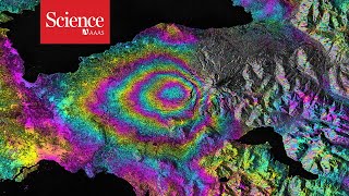
Detailed Description: Synthetic Aperture Radar (SAR) is capable of imaging day or night, penetrating dense cloud cover, and is suitable for interferometry. Although many SAR datasets are freely available with global coverage, they require complex processing with specialized software to generate analysis-ready datasets. NASA's Alaska Satellite Facility Distributed Active Archive Center (ASF DAAC) Hybrid Pluggable Processing Pipeline (HyP3) provides custom, on-demand processing of Sentinel-1 SAR data at no cost to the public. HyP3 is integrated directly with Vertex, ASF DAAC's data discovery portal, so users can easily find available SAR products and with the click of a button generate analysis-ready Interferometric SAR (InSAR) products. In addition to the Vertex user interface, HyP3 provides a RESTful API and a Python software development kit (SDK) so that HyP3 can be built into research and applications workflows. This webinar shows you how to request On-Demand InSAR products, both with Vertex and programmatically. We also demonstrate how to prepare an InSAR stack for time series analysis.
Explore SAR data, services, and tools at NASA ASF DAAC: www.asf.alaska...
Download presentation slides: go.nasa.gov/3B... - Věda a technologie


This is very brief and crystal explanation. Thank you.
Excelente video…
Puedo aplicar esta tecnología al estudio del movimiento de una presa ( dique de tierra)…..???
Gracias por tu ayuda….
Informative
I am glad you found this webinar useful Jayaprakash.
Thanks for the video, it was very helpful! The interferogram is just black and white when loading it into ArcMap. Which settings do i have to apply to get the colour scheme from the video?
Thank you for your message. I will reach out to our speaker and get back to you with a response. Please feel free to reach out with any data inquiries at support@earthdata.nasa.gov or visit NASA's Earthdata Forum at: forum.earthdata.nasa.gov.
This video was helped me to understand how to use. However, it should be updated since new features already come e.g. MintPy and also better to give workflow diagram before demo.
Good morning, thank you very much for this feedback. I will relay your message to our NASA Alaska Satellite Facility DAAC team.
Thanks to the NASA ASF DAAC, I was able to get hundreds of interferograms immediately.
Hoping to raise the amount of jobs that can be submitted monthly, e.g. 1000 ? ; )😄
That is great feedback. I will pass this suggestion along to the ASF DAAC. Thank you.