Modeling Biomass and Canopy Fuel Attributes Using LIDAR Technology

Vložit
- čas přidán 25. 08. 2024
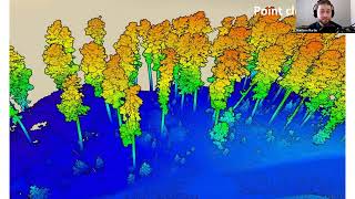
- Brent Mitchell, Remote Sensing Analyst, USDA Forest Service, Remote Sensing Applications Center (RSAC), Salt Lake City, Utah. Recorded talk from 2011 Restoring the West Conference at Utah State University. The conference focused on woody biomass harvest for restoration. By Utah State University Extension Forestry.


Nice overview about what Lidar is, does and what exactly is required to develop associated metrics (like biomass). Good work Brent
Which vendor ? Be specific ?
Hey thanks for the video. It was really helpful!
Did you publish a scientific paper with your method and findings, will I be able to access it?
which drone lidar that give the greatest acuration result..?
what does the abbreviation DEM means? i dont mean bare earth surface, i mean exactly what D-E-M stands for. thanks
Digital Elevation Model
What was the LiDAR pulse density for this study? How many pulses per square meter?
NIce Brent, wonderful information so why don't you ask Jess to up load some on MTBS and send me the link
How would I get lider software
Inches? Acres?
nice
sweden only has 4 tree species BTFO lul
Sweden definitely has more that 4 tree species.