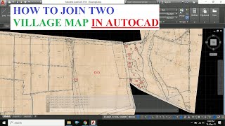
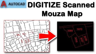
How to DIGITIZE a Scanned Village Map in AutoCAD | Raster to Vector

Vložit
- čas přidán 12. 09. 2024
- In this video I have shown how to digitise a scanned village map in AutoCAD.
First you have to insert a scanned map in autocad.
Then set scale and rotation to the scanned image which is called a Raster image.
you can use either SCALE and ROTATE command or ALIGN command in autocad to prepare the image.
This process is also used to convert a raster image to vector format.
Watch the full video and follow the steps to learn and explore.
Good luck.
Regards
S.Samanta
for L&E.


From Mumbai India thanx ❤❤❤
Psalm 9:1-3
[1]I WILL praise You, O Lord, with my whole heart; I will show forth (recount and tell aloud) all Your marvelous works and wonderful deeds!
[2]I will rejoice in You and be in high spirits; I will sing praise to Your name, O Most High!
[3]When my enemies turned back, they stumbled and perished before You.
By seeing thumbnail i subscribed😂👌
thanks dear from United kingdom
Welcome. Thank You from India for your valuable feedback 😊
সুন্দর হয়েছে। ধন্যবাদ। বাংলায় এই জাতীয় ভিডিও হলে ভালো হয়।
Sir is map ko google earth pe kese leke jaana h real location pe us par video banao plz
Thankyou so much sir
This is board of revenue project i also worked with 5+ maps yet 😉
good information? but how to Superimposed the same village map in a project master plane to find out whom and how much land is effecting
You can do it in QGIS
Please make a video on scale factor of Revenue Map or Cadastral Map & How to calculate Representative Factor when attached in Autocad Software?
Ei video tei to eta bola ache. Amar map anujayi 30 chain = 600m.
Asubidha hole call korben. 8910 837292
Thank you so much
You are welcome
Informative
Thank you so much
Sir y TSM machine m kya roll rhta h
Land survey ke kon konse kam auto cad me hote hai
Helpfull
Thanks
If village map not showing scale only plot area have given. Then , how can set pdf drawing in scale. Please, you will give me response. Thank you.
For this you must have some ground length as reference
Thanks 🙏
Glad it was helpful
sir aasha koi function bata sakte ho jisme ak object ke upar dusra object tracing karsake
Polyline command use karke karna parega
Is that project available ?
Parent chil relationship kaise banynge
Thanks please can you give me link to download autocad raster design 2010 64bit
Are color bylayer bhi kar sakte the
Ha wo v kar sakte he
onnu vabe o kora jay.3960 diye .otherwise scale to be different.
1:3960 scale ta direct dile hobena karon scanned image ta to all time true scale e thakena
How can dimensions of all lines be shown automatically
Difficult but possible with excel formula. Still you can't show every lines
could you provide english subtitles as I couldn't understand anything you said because of the language barrier
Yeah sure. I will update
Dada mouja map kotha theke Scan korbo r bepare Jodi blen to valo hay aamar bises anurodh thaklo apnar ka6e🙏🙏🙏
Apnar parshoborti elakay printer er dokan theke kore nin
HOGYA SIR
Great. Good job
Kya aap ye online mujhe sikha sakte ho? Fee?
Ji app ko kya sikhna he? Kindly contact me through whatsapp 8910837292
How to decode of tippan in telangana
Please make one video
Tippan means?
@@LearnExplore FMB
Sir
Yehi video Actcad2023 me bhi banaye sir
Please
Ok
Autocad download kaise kre
Naksha ki alag alag scale me kase print ya pdf kare
While printing try print by window and then select page size and input desired scale. You can use layout tab also
Object sanp is not working in this process.
It's just an image. Digitize it then enable object snap
Sir please share these video in English
I want to learn online Degitilasion map.
Map kase download kre ye ???
Map apko scan karna parega. Physically hona chahiye
Avi in ka koi vi coordinate kayse nikale
Use list command to export the coordinate.
Search export xyz coordinate from autocad to excel. You may find our video.
HOW TO SET ON GPS COORDINATE?
First convert the gps coordinate to utm and then plot the coordinate in autocad.
Then insert image and place it in your reference point
I have same doubt.Aise Drawing main GPS pe kaise set kare or use Ground pe Jake kaise layout kare
Please follow the mentioned step above
I AM NEW TO AUTO CAD IT IS INFOMATIVE BUT NOT GETTING
What not getting
@@LearnExplore i am following your method but the result is coming same
If can help me with team viewer that will be good for me if you have time then
Galt kyu btta raha hain bhai yese thodi hoti hai Jo ghatte honge field book uuske according hota hain bhai
দাদা, এই ম্যাপ গুলোর সফট কপি কোথায় পাবো ?
Revenue office e contact korte hbe
Dada apnar number save korlam... Konodin kono kaje problem hole ektu help koriyen...
Ok
sir total 30 chain mane bujlam na
1 chain mane 20m
Scale e 0 theke left e 10 chain amd 0 theke right e 20 chain
So total 30 chain
Which equals to 600m
@@LearnExplore ok thank you sir
Please Share with friends and LIKE 😊😊
@@LearnExplore ok sir❤️❤️
I mean you are a Bengali,huhh?
Yes brother
@@LearnExplore can I get a contact of you, please!
Sir apnar WhatsApp nambar ta powa jbe?
8910 837 292
@@LearnExplore thanks
No this is not the proper process of scaling.
Other than the unnecessary line, there was nothing wrong with the scaling.
Then how?
@@LearnExplore first of all you have to define the unit of map in case. The chain scale maximum time is not perfect. You have to enter a map in B/W format and specify the scale which is the divisional function of 100. The scale is 1:3960. Find the divisional function. I have done 45000 mouza map recreation.
I am interested in your method. If you agreed we can talk through whatsapp 8910837292
While inserting image can we use the 3960 factor? I think it may depend to scanned map size or pixel
Ye to bacche bhi jante hai kuch Naya bata
Ye to he. Par beginners ke liye ye video diya tha. Hamare channel me advanced video v he. Pl watch
Thanks please can you give me link to download autocad raster design 2010 64bit