Getting Started in Celestial Navigation (The Marine Sextant)

Vložit
- čas přidán 25. 06. 2024
- Free and discount marine navigation courses: www.practicalnavigator.org/
This video is part 1 of the "Getting Started in Celestial Navigation" video series.
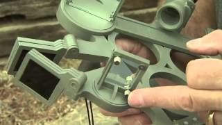
Part 1 of "Getting Started in Celestial Navigation," (The Marine Sextant) describes the marine sextant, it's parts, and how to measure the angle from the horizon to the sun. It also introduces the concepts of "limbs" and how to read the sextant.
Here are some additional resources pertaining to this lesson:
1. Wikipedia "Sextant" - en.wikipedia.org/wiki/Sextant
2. How to build a simple sextant - www.tecepe.com.br/nav/CDSextan...
3. Artificial horizons - www.sailingmagazine.net/how-to...
Navigation Materials
All example problems in this course use the 1981 Training Nautical Almanac and HO229 (there are no example problems in this lesson).
1. The 1981 Nautical Almanac
Hardcopy 1981 Training Nautical Almanac - www.amazon.com/The-Nautical-Al...
Note you can also download for free or minimal price online by searching google, for example ebookpie.com/ebooks/300803-th.... You can download it from lapware.com if you pay the monthly fee for access. Sidenote - lapware is an amazing training tool!
2. HO229 - Sight Reduction Tables for Marine Navigation
Free download - msi.nga.mil/NGAPortal/MSI.port...
3. Other materials of use
Free download of Bowditch (The American Practical Navigator) - msi.nga.mil/NGAPortal/MSI.port...
USCG licensing website. This contains all the possible questions on USCG exams - www.uscg.mil/nmc/training/exam...
The book I used to learn celestial navigation myself, and I think one of the best celestial navigation books out there, is "Common Sense Celestial Navigation" by Hewitt Schlereth - amzn.to/2O8evTa
Produced and presented by Christopher D. Nolan, USCG cutterman (8 years) and US merchant mariner (1600 ton Oceans).


I'm really surprised to see an instruction about sextant now.
It reminds me of my celestian navigation I took at school in the early 70's and our long navigations when we used celestial navigation extensively until 20 + years ago … and then we became stupidly lazy.
There is nothing more satisfying to make a right course thanks to celestial navigation, there is no more satisfying thing to know where you are relative to the land / continents and to the celestial bodies…
I do miss that a lot (along with the rest of sailing of course…).
@Lelz Rofl Dude ! You made the best response in YT since a very long time.
Yes it is 5 000% more interesting than GPS and more …
Cheers, Happy New Year and best of luck !…
Lelz Rofl it’s wild how some of us are drawn to the sea... and then boring people like you are scared of water
@@stuarthiggerson5846 Your response is so predictable : who's boring ?
My father was a master mariner/marine surveyor in the early '70s. I am only now at the age of 64 learning to use this instrument in spite of his eagerness to teach me because in those days motor cycles, horses and girls were far more important. It does give one peace of mind.
Thumbs up.
man your way of explaining is so simple and up to point even a small child will grasp this easily ..much blessing to you mate ..
Several years ago while my wife and I were taking a cruise, we had the opportunity to join a group tour of the bridge. After the Captain finished describing the advanced satellite navigation systems and sophisticated displays, one of our group (sarcastically in my opinion) asked where they kept the sextant. An officer walked over to one of the desks, opened a drawer and pulled out, with a subtle smirk, a sextant and paper map .
He never asked another question. It was great to see.
Every Captain worth their salt would have one on their ship. Early Boeing 747 even had a sextant.
Dude, this is the third video about the sextant I've seen, and it blows the other two to bits.
It's some of the same material, but presented in a way that a complete novice (me) understands every concept presented.
You're the rare combination of a subject master and an effective teacher -- well done!
Thanks for the kind words Dave, enjoy your journey in celestial navigation!
Excellent teaching video! Your presentation style is outstanding, the use of video close ups on the micrometer, the use of the laser pointer, and the thought the glass views are all very well done. I wish I had seen this video 26 years ago when I was learning how to use my sextant before a voyage. Your video clearly explains things. Fair winds sailor!
Thanks for the kind words, all the best to you.
You made it really simple while also showing us what it looks like observing it from the lens. Thanks!
Wow, I always thought using a sextant would be crazy complicated... You made this piece of metal that does magic into something logical that actually makes sense.
Outstanding series Chris. I did a tour on the carrier Carl Vinson CVN-70 in the 1990's. The navigator did his sextant readings daily, morning, noon and evening. I asked him why he bothered since he had GPS etc. His reply was that if there was a war (nuclear), GPS and all of that stuff would be gone and he would be back to navigating with the sextant. Convinced me to learn this skill. Glad I did!
Grandpa Jones
Better to have and not need then need and not have
The Communist Chinese have been frequently JAMMING all GPS reception over vast areas of the south China sea and South Pacific ocean!
And we're not even at war with these bastards!
@@pemaangya5830 Pema Angya
Grandpa Jones
Thanks! This is easily the clearest, best presented, and most comprehensible explanation of how to use a sextant that I've ever seen...and at a total length of 7:51, well within the attention span of at least some CZcams viewers. :-)
An excellent video for learning the basics of a sextant. The setting gave me chills from great memories!
Thank you for watching and for the feedback. I hope future episodes are useful!
Great video! I've never understood how it was possible to measure such angles to such high resolution while sitting or standing on a moving object. Obvious when you know how. Thank-you!
Thank you for sharing your knowledge, very much appreciated. You are a good teacher.
Thank you for watching. Part 3 and 4 should be posted by May 5th. I highly recommend the program called Lapware. It costs $100 per month - so use it wisely, but it has every type of problem you could be asked, and allows you to take practice exams. Most people take a course for celestial - depending on your timeline I will have a few more training resources available in the next 2 months that I can pass along. Thanks again!
Outstanding work, Christopher!
Thanks for watching, I wish you good luck in your learning!
I would like to thank you for the videos...I am sitting for Exams and I found them very helpful. All the best to you. Thank you again
As a new Merchant Mariner/Seafarer I love videos like this that teach the traditional ways of navigation and the old tools like the sextant! Thanks so much for sharing! This is very interesting and informative! I want me one now! 🇺🇸⚓️🌊⛴
Glad it was helpful!
Hi sir
Great video!! Looking forward to studying it- thanks for posting
Thank you.... I had great hustle getting it from class....
This is great, very instructive and well presented. I like how you start simple, with basic concepts, and add layers of accuracy and detail later.
Very Good Video for beginners to try and take hold of this most difficult subject, Thanks!
Just found these videos. You're a very good instructor - thank you for making these!
Nice video. I am going to to learn this. It got me thinking how the sentiment these days is that we've left the entire past in the dust with the computer age. I can rarely get someone under 35 or so to be interested in anything not "techy". But can you imagine the minds the developed a technology like this. If I understand correctly it is accurate to within 1nm. The first sextant dates to around 1759. what is that, 264 years? I find that just amazing. No batteries or connection required. A beautiful, to me, tool and a book. And a brain.
Quick, clear, simple. Well informed video.
Hi Chris! I very much like the smooth and veracity of your material. I am in the process of getting my first sextant and I hope some day I could shoot at the stars and put in practice what I have learned. Thank you for your kindness and for sharing your knowledge with others. May the Lord who created the heavens and know all the stars by its own name keep you safe out in the ocean by having always a heavenly body over your vessel.
Excellent instruction. Thank you.
Just starting to learn and this video is excellent and so well presented.
Thank you extremely helpful and informative
Great explanation. Thanks for all the links to resources.
Thank you Chris. Great work
Great, well thought out video. The dual view shots during adjustment are perfect. Thanks!
What an awesome explanation. Keep pumping out these videos. Great job man.
I showed this to my kids today. We are studying inventions and the compass and sextant. Very interesting video. Thank you.
Excellent tutorial and links. Keep up the good work!!!
Great tutorial and facinated to know how this device (sextant) works. (thanks)
Dude's got flames on his sextant. Freakin' LEGEND!!!!!!!!!!!!
Sir, I am a nautical science student and its for the first time I am understanding how to use sextant.. well taught sir
Excellent explanation of reading the Vernier Will. This is something I've never felt comfortable with until this point and that explanation made it crystal clear very well done video
Being a new Merchant Mariner/Seafarer I am very interested in learning the old school navigation methods and tools. This is very interesting and informative indeed! Thanks for sharing!! 🇺🇸⚓️🌊⛴
Went through about seven other videos on the sextant in attempts to try and teach my sons. Most videos taught vocally using just words and maybe a few complicated drawings. Was losing my sons interest when they kept asking what they meant by bring the sun down to the horizon. Your video not only explained everything, but you showed my sons the actual image of what they would see through the sextant sighting glass as well as the micro adjustments. Your video was greatly superior to other teaching videos in regards to budding young sailors. I smiled when they got that "Oh! That's what it's supposed to look like" look on their face and went straight to their sextants to get the same image. Watching their arms rock back and forth and coming back to your video for reference told me this is the video to bookmark and save. Thank you so much for a wonderful teaching video.
Thanks for the kind words, good luck!
Brilliant! I am just doing a course on Celestial Navigation, and this is a wonderful explanation on how to take the measurement. Thanks heaps :)
a well spoken young man and very good presentation
Thanks! Yep it's a Astra 3B. The flame job is custom :)
Excellent tutorial. Thanks!
Hi. Great video. nicely pitched ...not too in depth but very informative. I'll be checking out your other vids and thanks for posting...
Really enjoying your videos and the illustrations are helpful. I am a toolmaker so I need to use trig a fair amount, so celestial is becoming more clear to me. Already purchased a slightly used Weems and Plath sextant. Now for my next sailboat. You cant spend all your time working!
Thanks for the video I'm not a navigation person but have always been interested in sextants. I understand how useful they can be.👍👍👍
Very well explained, all that we need now is the formula to get the answer that we are looking for, thanks.
Hi thank you Alan, the next videos in the series start to talk about the formulae for the process, thank you!
Damn, I wish I had you as my celestial navigation instructor in the navy. " Rock the sun"
Very good! Thank you.
A sextant (and any protractor, but with varying degrees of accuracy) can also be used to do a lot of other nifty things. You could, for example, measure the angle between two or more landmarks (usually on the coast), trace the lines/angles on the chart, and triangulate your position.
Excellent. Thanks. Always been interested in this. Thanks for explaining so well.
I've always been a pasionate for astronomy and naval history, the only thing I never ever touched in my lectures is how to navigate. Such a nice tutorial!! :D
i learned something new and awesome, thanks!
Nice video, thanks for the help.
I was a navigator in the merchant navy before the GPS system. I`ve made thousands of these calculations using HO 211 and HO 249. The stars in the morning and the evning made the best fix. Six or seven stars within five minuts. I did`nt like when the D.R. became older than 24 hours because of overcast. Navigating through The Red Sea was horrible because of extensive refraction. You could not thrust the horizon like you can not thrust anything else in that eryea.
Thanks Hans, I can imagine the Red Sea must have been a difficult place to navigate! Thanks for sharing your story!
hans klint: Noticed your comment that cites two sources, 1-HO 211 and HO 249, for determining calculations. Why use two different methods ? Is one more accurate or faster ?
hans klint
I'm Portuguese and my uncle works as a first year professor at the Lisbon school of navigation but is from the Azores. I try using their facts to prove a globe (flat earthers) but they don't listen. They only use aviation not maritime navigation.
+Larry Medina
Actually Flat earthers will deny even the very nose on their face if they think it's being used to prove them wrong.
Roger Baker - Sorry to have to correct you - but Level is NOT the same as Flat.
Level is a plane at right angles to a line from your position to the centre of the Earth.
Flat means there is no hollows or humps.
Look up your dictionary.
Celestial Navigation DOES use SPHERICAL TRIGONOMETRY math to calculate a position line - so where you get the idea spherical trig has no practical application suggests you have never done an ocean passage where you are out of sight of land for days on end - never used a sextant and never done the calculations for yourself - never plotted a Celestial Sight calculation on a chart.
I have sailed about 5000 nautical miles on offshore passages - some legs more than 1000 nautical miles like Auckland to Savu Savu, Fiji - and Auckland to Nukulofa, Tonga a couple of times in small yachts.
Excellent video. Thank you
Excellent...clear and concise. Oh, to be in the summer sun again. It's the middle of February here in New Jersey.
Thanks a lot buddy, excellent......
that was great...first time I've ever looked at a sextant..better late than never...
If you found this interesting, you can buy a very basic sextant for less than $50: the Davis Mk 3, which is a plastic version of the WWII lifeboat sextant. There are also patterns available on the Web for making your own sextant out of wood or cardboard. (Probably for using a 3D printer, too, but I haven't researched that.) It's fun to actually put the skills shown to use; better than just reading/watching about them.
Excellent presentation Chris. I taught day and night time navigation in the Army. We used lensatic compasses and maps but shot angles to landmarks. We had little training on celestial nav except the location of Polaris. (TN) My cousin is the navigator I really admire. He shot stars in the P-3 Orion. (What a name huh?) He was in the Navy back in the late 60's, early 70's. I admire those who can navigate the great oceans and bodies of water her on this earth. I'll be joining you on future lessons. Anchors Aweigh!
Nice job. Thank you much
Great explanation... you have a knack in making sound easy :-)
when I was in the Navy we were transiting from the Panama Canal to San Diego. We lost our Loran and couldn't get a good idea where we were. We surfaced and our Navigator went to the bridge shot the stars and got our position. Once they fixed our navigation systems it was determined he was correct within 100 yards. Not bad!
Many thanks for a great lesson!
Thanks for the lessons.
Nicely done. Thanks
That was a excellent explanation thank you.
My dad flew for the Army Air Force and the USAF for some 33 years starting in ‘36. He taught navigation, communication and was a whiz at keying Morse code right up to when he died. He said the stars were a superior reference. I don’t know that he ever used a sextant but he would have loved playing with one of he had had a chance.
Kim Horton : yes of course he used a sextant to navigate with, from the Navigators bubble canopy atop the larger Aircraft, transports and bombers. He also used Radio directional antennas to fix location and course. What a wealth of information, and history, he had !
great vid and gorgeous gorgeous footage.
Very useful review
Very informative, thanks
Nice guide! Thank you
Thanks for the info.
Seems a very good presentation.
Great videos Chris! Keep producing them, more detail though. I like the sailing video too, I'm stuck in the desert.
haha you are stuck in the desert and you keep seeing water everywhere no that's not water actually I meant mirage
I love your style of teaching. I always wanted to learn how to use a sextant and ive been looking at so many different videos but they just confused the hell out of me and didn’t give me an idea of what to look for. This gave me way too much confidence that I’m ready to go right now 😅 even though idk the equations or anything lmao I’m just excited I finally know what to look for an how to work it and what each dial means lol
You are so welcome!
gracias por tan buena explicación
Thanks, great video
700k views! Heartwarming to see I’m not alone ❤️❤️
Hi Chris, We are a homeschoolin' family and just read "Carry On Mr. Bowditch" by Jean Lee Latham. I wanted to learn more about reading a sexton and found your YT. You are a modern day Nathaniel Bowditch! It is children's literature but an excellent book to read-consider it. Thank you.
excellent , very informative.
Thank you so much
You have produced excellent videos. It would be nice to add, how to calibrate a sextant, (the mirrors) before taking a shot.
Thanks for the feedback, I'll look at that topic for the next video series in the spring. Thanks again!
Nice learning with you, I have one and studying trigonometria
Odd although I have not searched or spoken of Martinique in the presence of any of my devices it has been on my mind for the past week because of an old movie that came to mind. You're talking about something outward a refresher on. Some people call it Serendipity some people call it Kismet. I'm just happy that it came up.
Thank you this is great!
What a godsend of tuition. Also, what a piece of kit. I'd assume that captain Bligh's sextant was a little more primative than this piece of cutting edge technology 🤔
loved it
Thanks for the tips, Jim from The Office.
this was a lecture not a tip
Thanks
Great video
Thank you mate....
Thanks for the videos! Definitely will be a BIG help when I take the Celestial Navigation USCG module. Besides watching your videos, what is the best way to learn Celestial Navigation for passing a Coast Guard Exam, any training material you recommend?
Thanks man for good information!👌👍✌😊
Hi, I'm new to navigating. Can you explain how in 2:39 is it 31'40" (31.4'?)? I'm confused as to what line I should be reading from. Is it because the decimals "start" just after the first short line after 30' and the .4 matches a line? Thanks!
thanks for this
Excellent videos, by far the best I've found in the web (and I've seen quite a few). One question about the noon sight... I'm doing fairly well on latitude but my longitude is consistently off by 20+ miles. I've read the challenge is that the sun's path flattens near the top of the arc so it's hard to tell accurately exactly when it occurs. I've read that this is an inherent limitation of this technique and that even "shooting the arc" (before and after local noon, and averaging to find the midpoint) is not very accurate. Is this true and if so, can you explain why shooting the arc is not so accurate (it seems mathematically sound)? And thanks again for the videos.
Chris Doubleday Hi Chris, great questions. Congratulations on the noon latitude sights, I'm happy you are having success! Everything you said is true - longitude at noon is possible, but a bit hard. The strategy is mathematically sound: in broad strokes what you need to do is measure the sun a bit before noon and note the sextant reading and exact (and I mean exact) time. Let the sun go up, then down again. When it reaches the exact (again, I mean exact :)) height as before, note the exact time. Average the times and you have the exact time of meridian passage. The reason for exactness is the sun moves "over" the surface of the earth at about 1 mile every four seconds...so you need to be precise. Once you know the exact time, calculate how many hours, minutes, and seconds you are late on Greenwhich time...convert that time to arc (using the nautical almanac 'conversion of arc to time') and you should be about as close as you can get. Watch for common errors in math, make sure watch is synched to correct time, and also be careful with time zones and daylight saving time.
Just personally, if I were to rank order the steps I would want to learn celestial navigation, I would put longitude at noon towards the end...it is a more complex topic. Another cool trick you can do for longitude is use the horizon as a sextant...around sunrise and sunset, the sextant height would be zero...no sextant required. There are a bunch more corrections for atmospheric refraction, though. But it should give you a longitude line.
All that said, for primary means of determining longitude, I recommend doing morning and afternoon lines of position (later videos in the series) and then getting a running fix (or use multiple bodies like a sun/moon fix).
Hope that helps and good luck! - Chris
If you are shooting a sighting in the hood, do you hold the sextant sideways?
LOL. That's a crappy way to hold a pistol too.
Too funny...
lolz
Only a gangsta pirate would do navigate the high seas that way!
Of(f) course.
it´s gorgeous my fellow. Keep it up!!!!
That's so cool!