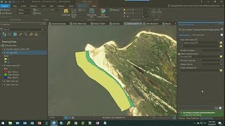
Shoreline Change Analysis/Prediction of 2030 and 2040 shoreline/DSAS

Vložit
- čas přidán 16. 07. 2021
- Shoreline Change Analysis/Prediction of 2030 and 2040 shoreline/DSAS
Satellite Image Download - • How to Download Landsa...
Shoreline Change Analysis in Arc GIS - • Shoreline Change Analy...


Sir I am a Ph.D student of Delhi University, I need to learn this DSAS tool. I can pay for this course. But I really want to learn this. please help me out 🙏
please can you show me how to
plotting the shoreline positions with respect
to time and calculating the linear regression equation
Contact through my mail : logeshw77@gmail.com
I also wanna know it, anyone can help me?
sir, can you please let me know, which band of satellite image has been used to digitize the shoreline.
You will use any band or FCC and Tcc
@@gisandremotesensingbasics6791 ok sir
How can we measure shoreline accuracy and data validation?
This is possible only on field verification
Okay,but how can we measure also uncertainty?
@@mdsaifulislam8596 just give 1,2,3. Its depends upon number of shoreline
My shoreline data is from 1984 to 2020. I made the prediction for 10 and 20 years, but the answer was ForecastYear 2032 and 2042. Wasn't it supposed to be 2030 and 2040? What's the mistake?
how to predict the shoreline change?