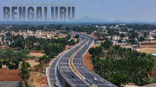
Unveiled: Explore Bangalore’s upcoming STRR with Stunning Drone Footage (Latest!)

Vložit
- čas přidán 28. 06. 2024
- Experience the Bangalore Satellite Town Ring Road (STRR) like never before! This video features the latest drone footage showcasing the entire route, from Baglur to Devanahalli Airport. Soar alongside us as we witness the evolving landscape, key connecting towns, and the vast expanse of this under-construction marvel.
The 288.8 km expressway will primarily run through Karnataka, covering approximately 85% of the total distance (243 Kilometers). The remaining 15% (around 45 Kilometers) will extend into Tamil Nadu.
The project aims to connect 12 satellite towns of Dobbasapete, Devanahalli, Doddaballapura, Sulibele, Hoskote, Sarjapura, Attibele, Tattekere, Anekal, Kanakapura, Ramanagara, and Magadi, creating a smoother traffic flow around the city.
This "greenfield" expressway is being built under the Bharatmala Pariyojna project. It involves constructing a new highway (NH-948A) and realigning an existing one (NH-648).
The STRR promises to reduce traffic congestion in Bangalore and provide a faster, more convenient way to travel between these towns.
The STRR holds the potential to:
Reduce Traffic: By diverting traffic away from congested city centers, the STRR aims to significantly reduce traffic congestion leading to smoother commute.
Enhance Connectivity: The project will connect eight state highways and six national highways, making it easier to travel between different parts of Bangalore and beyond.
Boost Economy: Improved connectivity can stimulate economic growth in connected towns and facilitate the movement of goods and services.
Unlock Development: The ring road may encourage further development in satellite towns, creating new opportunities for businesses and residents.
Video Highlight
0:00 Development from Baglur to Devanahalli
0:10 Connecting 12 towns
0:16 Baglur is the starting point for our aerial exploration
0:33 Evolving landscape on our drone flight to Dunnasandra
0:55 Witness the route from Dunnasandra to Cheemandahalli
1:09 Next stop on our aerial adventure: Hoskote
1:32 Chokkahalli comes next
1:51 The final stretch towards Devanahalli Airport
Take a virtual flight along the STRR and see the future of Bangalore's transportation! Leave a comment below and tell us what excites you most about this project.
The future of Bangalore is full of exciting possibilities. Be a part of it. Discover the unparalleled convenience and luxury offered by Modern Spaaces. Visit modernspaaces.com to learn more about the upcoming projects near the STRR.


Make vedio on bagaluru to hosur strr road
Informative video
Tejas.s 😊
Which intersection will be closest to modern spaces properties. ?
Atleast 15km to chikka tirupati/bagalur 😂
3+3lane roads for North India and 2+2 for south.
Thank You BJP. BJP again in 2029.
Thank you BJP govt ❤️💕
this is rahul Gandhi’s vision and plan for Bangalore. Stop you blind devotee of Godi
@@ravinunna1168 louda 2019 inaugurated 😡😡 under BJP government