Plate Tectonic Evolution of North America - Scotese Animation

Vložit
- čas přidán 13. 12. 2015
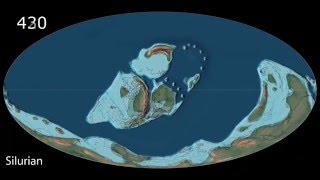
- This animation shows the plate tectonic and paleogeographic evolution of North America from 200 million years ago to the present-day. North America was originally part of thee supercontinent of Pangea. About 200 million years ago, Pangea rifted apart. To the east of North America, the Central Atlantic opened. About 150 million years ago, South America rifted away from North America opening the Gulf of Mexico.
Please cite this animations as:
Scotese, C.R., and Scotese, J.D., 2006. Plate Tectonic Evolution of North America, PALEOMAP Project, Evanston, IL • Plate Tectonic Evoluti...
Prof. Christopher R. Scotese
Director, PALEOMAP Project
134 Dodge, Evanston Illinois 60202
817 914 7090 (cell)
For more information about the research, publications, and animations of C.R. Scotese, see the links below:
Download complimentary copies (pdfs) of Scotese publications, visit: www.researchgate.net/profile/...
or uta.academia.edu/ChristopherS...
View Scotese animations at: / cscotese
View interview of Professor Scotese: • Paleogeographer's Song...
for more information about the PALEOMAP Project
/ 932
or www.scotese.com
APPS:
Free app - EarthViewer (Apple/Android) showing plate tectonic and paleogeographic evolution through time: www.hhmi.org/biointeractive/ea...
Also check out these apps for the iPhone & iPad:
Cover Art
Ancient Earth: Breakup of Pangea
Thomas L. Moore
Category: Education
Updated: Mar 19, 2012
ALSO Ancient Earth Assembly of Pangea (200 Ma - 540 Ma) itunes.apple.com/us/app/ancie...


I know Chris he was one of my instructors at UTA he has been working so hard on these videos for years. Great job
I am going to cry now
@@adam_hase well I always do so.
It's a shame he couldn't say hi here.
I can't even begin to imagine the amount of work required.
One can only admire the way the Chicxulub crater is depicted here: kind of a teadrop shape at first, running from southwest to northeast (as a result of the impact at a shallow angle), then transforming into a progressively round shape; its rims at first colored black (probably to show they were charred), then fading to "normal" color; finally, the whole thing fades into the sea as a result of erosion.
Congratulations on creating such a great animation with such a level of attention to detail!
Impact craters are round, round, round, whatever the angle, just look at the moon for an example. Deformations might come from the projection used here
It's amazing how large the Western Interior Seaway was. It's equally amazing how extensive was the uplift that resulted in its disappearance.
At one time I lived at what would have been the western end of that seaways and these days the prroximate elevation is about 5000 feet above sea level.
* uplift and ice age
My sister in Missouri would'nt believe her house was once under a shallow sea till I went out in the yard and picked up an excelent fossil brachiopod.
Part of the water for the Interior Seaway and other ocean intrusions came from uplift at the speafing centers. The rest came from the lack of continental ice caps. Even today we have large areas that are interior seaways. The Java Sea for one.
Very informative--and quite magical. Thanks.
This is exactly what I've been wanting to see. Thank you so much!
This is so awesome thank you for doing this!
I really enjoy your plate tectonics videos. It's fascinating to see how the face of the the earth has changed over hundreds of millions of years. Thank you for posting these so we can learn more about the history of Earth.
Fascinating. Thank you.
Fantastic work. Thank you.
This is great! Thank you!
Thanks, that was excellent.
Fascinating. Thanks.
I've watched this several times already and still love it. Being a Physical Geographer/Geomorphologist, it gives me warm fuzzies!
This is excellent. Thank you very much.
Very educational and awesome aesthetic sound. What a great contribution to mankind in America. Very well done Christopher.
Great stuff! Thank you.
Thank you for including the glacial growth and retreat. I enjoyed the video very much.
Well done! I hope to see more!
Nicely done, thanks.
Even though it was millions of years it still progressed slowly. The amount of torque that must exist on the surface of the planet from the rotation, the moon and the sun must be enormous. Thank you that was amazing.
F
Torque. As if earth's mantle is a gearbox? That's actually a cool way to think about the whole process of tectonics and earthquake generation...
Thank you, great job,
Amazing. Thank you
This is so beautiful that I almost cried!
This is wonderful! In Washington State, the paleo joke is that the West Coast is the "new coast" because everything west of Montana immigrated :)
I hadn't realize how big the central internal sea was - that the whole continent was completely separated - nor that "Florida" essentially retracted and then came back out again.
Thank you for this!
Of you want some really good geology on Washington state look up Nick Zentner on YT
Me neither. I knew there was one, just not that it was so large. I lived almost at the edge of what used to be that seaway, near Canon City, CO.
The area that is now the West Coast is where _Tyrannosaurus rex_ was found.
I would have loved to have seen the accretion that built the west coast. Not complaining, this is astonishing work.
And I just found the other videos that show this. 😊
WOW? I did not know that this is how North America was born, I'm amazed of what this person did with animation is great for teachers to show students this i-tube in geography class. Many Thanks for putting this together.
Not depicting Siletzia whatsoever makes this a bit flawed.
Wonderful animation on Wegener theory!! And free information!!! Very good to see! Congratulations !!
Fantastic!
Thank you!
So beautiful it nearly brings tears to my eyes every time I watch it!
I wish you could see my face as I watch. Thank You!! Great Job!!!👍👍
This is mind-blowing and very humbling.
Both Scotese and Scorsese... with epic plot development and character formation. Good job.
Love the piano work
Thank you
I grew up in central southern BC near the town called Cash Creek. Just west of there there is a whole mountain of salt water clam fossils This hill is now about 4000 feet in elevation and roughly half way between the Rocky Mountains and the BC COAST, interesting.
Great animation!!!
No commercials. Amazing win for science.
So cool to see how old the Appalachian mountain range is
He just didn' start it early enough, back in the Silurian we had some nice sea coast and beautiful reefs across the northern third of the state. I'm not quite old enough to remember them, but when the wooly mammoth were tramping around Fort Wayne, now that was spectacular. And the run-off from that last glacier, even down New Harmony pretty chill......
From what I've heard, they were once bigger than the Himalayas are today!!!
Thanks
I like to tell people that this (I'm in Virginia) was once the center of the earth! because it was basically the suture line between N. America and Gondwanaland that formed Pangea. I'm a little confused on the age though, some of the rocks in the Appalachians are a Billion years old, but maybe are exposed plutons from erosion.
paul joe Cocomo idk
Thanx 😎I'm here because professor Nick Zetner mentioned your maps😎
Today I live on the western shore of the uplifted and fractured bottom of the Cache Creek Sea. My house sits on ground that used to be in some tropical part of the West Pacific, and is now in Washington State. When I was in high school, nobody had any idea of this. What a world!
And in northern Australia, there is land that probably part of WA state. I live on the Kitsap and it's fascinating and awesome to think of how much of the state is actually exotic terrane. And that the Columbia River Basalt Group is not only the work of the Yellowstone Hotspot but that the hotspot itself used to be underneath Vancoiuver Island/Olympic Peninsula at one time (about 50,000,000 years ago).
Looks great! Only I am missing Siletzia, which formed about 55 - 49 ma. ago (if I recall correctly) and 'docked' partly at the west coast of Washington and partly at Alaska about 50 - 45 ma. ago. Or wasn't I paying attention?
Excellent video. U just got a new subscriber my friend.
Amazing
Magnificent
Hey Christopher I really enjoy your work. Thank you for posting these videos. I am however curious about the nature of the boundary of the Eurasian and the North American plates in N.E. Siberia. Are they diverging, converging or slipping past one another? On most maps they are either at the edge of the map or not clearly defined. I would love to hear your opinion.
Excellent,!
Excellent
I like that this simulation focuses only on North America. It omits other areas of the world which could be distracting in order to see the detail of N.A. I also like that the ice age that created the Great Lakes and Hudson Bay was included. It gives a more layered story of the evolution of the continent.
The only continent that matters really let's be honest...
Good music and showing land areas
Extremely interesting video.
Didn't expect this lo-fi earth experience, but I love it.
I noticed the Manicouagan Crater in Quebec 200M years bp.
Did you notice the three (possibly four) in the Colorado area at the 60 ma mark? I have never seen that before. Interesting.
Well done and informative.
The movement is probably fairly accurate. Only small pieces of the actual positions of landmasses is probably accurate. We just don't know what most of it actually looked like. However, this video is extremely interesting and gives a good overall picture of what happened. Good job.
Fascinating
At 3:17 you get to see where the Chicxulub Impact (about halfway between the center and bottom of the screen).
4:39
Michigan: I must make my entrance
Why that was amazing. I am dazed.
I watched it 5 times thank you
looked pretty cool
Thanks
Wow cool!
Cool.
a good portion of Western North America consists of terranes dragged along by the subduction of the Farallon and Kula plates.
I did learn in one vids that one of the markers of the original west coast of the Old North American body is the Belt group, named after the Big and Little Belt Mts in Montana,
As the Little Belts are between Bozeman and Helena, not far outside Bozeman, and one of the nifty features at the east end of the Little Belts is the HOrseshoe Hills, this is fun, because one of the main features of the Horseshoe Hills is the massive beds of trilobite fossils, which are basically prehistoric ancestors of the modern horseshoe crab (thus the name for the range of hills).
As Bozeman is close enough to Yellowstone that as a kid we used to, in summer, regularly go into Yellowstone for Sunday drives/picnics, that is how far inland the old core of the continent is.
that´s great
nice production; do you have one for each of the other continents?
Always amazing. New for me was the northern latitudes moving west to create Alaska. Also, my home state of Michigan was rifting apart before 80 Mya. Then after it is being shoved back together.
Interesting piano music accompanying the animation.
The song is "There's Probably No Time" by Chris Zabriskie👍
Thank you
Thank you
Beautiful music.
It's pretty cool how you can see the farallon plate disappear little by little
Have you done a time lapse video of the hotspot that moved under the north mid-Atlantic Ridge and the formation of Iceland? Did it travel under Scotland and Ireland forming the Giant's Causeway?
Great work! We think to be on a steady situation, but this is only our illusion, a misconception. In reality all is changing continously; nothing is for ever in the universe
Beautiful animation, and beautiful music! What is the music piece called?
Plate Tectonics wonderfully displayed.
Nice
Chris professor Zentner sent me here. A fan of his and now of you. Keep him informed will you.
Proof nothing happens in Indiana
Well, for a long time, then y'all got a mile or two thick ice sheet across the northern half of the state...
Illinois got to be an ocean for a little bit. That was cool
@Donald J Who's your "iridium" dealer?
In the future Indiana will be where all time travel departs from....
@@0neTwo3 i could see that
Central ocean then one huge inland sea then 2 smaller seas then one salt lake then
Mormons!. Brilliant 🌴
Well done, Christopher, I've been looking for a well-done version along these lines. A close-up of the Pacific Coast, specifically the Juan de Fuca plate, would be even cooler. Upcoming seismic activity will make this video even more informative, unfortunately.
2023/8/5. Great Job !!
I liked the piano music, but adjusted the speed to save time. Thank you for your efforts in making this.
nice
nice music
Interesting to see how “last minute”, geologically speaking, Florida appears. It’s such a noticeable feature in North America and yet it wasn’t even there for the vast majority of its historical existence.
Give me a break. The bulge on the south eastern tip of the North America is there in the first picture and is always there.
@@TomTom-rh5gk You're actually sort of right as I watched it again. At 0:48 in the video or early Jurassic there is a slight bulge in the SE covering northern FL, as the map still shows present boundaries. However, at 1:27 (late Jurassic) we see it disappear and not reappear till 1:51 or early Cretaceous. Then, it's above water only 100 million years while still in the early Cretaceous and poof, it's gone right away at 2:06 in the video. From there it's gone a long amount of geological time until a little over 10 million years ago at 4:23 finally narrowing to its present shape a few hundred thousand years ago. So, all told, out of 200 million years, the bulge on SE North America exists for 50 million years and is under shallow water for 150 million (three quarters of the time). So we're both right ;)
@@TomTom-rh5gk it floods for a while
@@bcs2em625 I completely agree :). You are right it does disappear and few times. But Florida seems like it wants to be there. It could be a trick of the mind but it seems like certain features keep coming back. I would love to see you do a video on how Africa keeps its shape and how Huston Bay keeps playing peek a boo. And if you can figure out why that would make a great paper.
Gulf Mexico inpact crater?
Well the animations are really cool. It even showers elevation over millions of years.
Enc3ladus - QuikScience l
F
Chris do you think you could do a present projection of where NA is sposed to end up in 50 million.
What music is used? It's haunting.
this was so coooooooooooooooooooooooooooooooooooooooooooooooooooooooooooooool
Congratulations
Now lets have a similar animation showing the evolution of North America over the next 200 million years according to your best guess.
I like it
Does anyone have a video that speculates on future configuration?
items to add to this animation that would cool. locations of select cities on the continent (for reference) as well as Yellowstone Hotspot as it moved across the west coast into Northern America (because there are several old calderas still in existence)
Just in case anyone is interested, the piano track is by Chris Zabriskie and is called "There's Probably No Time".
Great video . Would of been nice to see the Yucatán meteor impact.
Check 3:19
I love the fact the the Chicxulub crater was included
Very cool watching our world surface evolve. It’s never over till it’s gone. We should treat it with respect. I try
There's Cache Creek! and Stikinia! Brings back good memories from Nick's Exotic Terrane series.