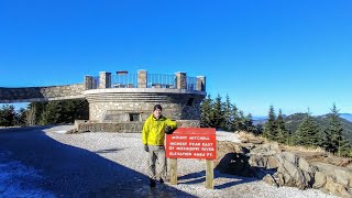
Black Mountain Crest Trail - Pisgah National Forest, NC

Vložit
- čas přidán 8. 09. 2024
- A difficult hike along the entire Black Mountain Crest Trail starting at Bowlens Creek and ascending 3,000+ ft to Horse Rock Meadows below Celo Knob. From there the trail roller coasters over 4 of the tallest summits in NC before terminating at Mt Mitchell, the tallest peak east of the Mississippi River. This was performed as a shuttle hike. The trail starts in Pisgah National Forest and ends in Mt Mitchell State Park, traversing the crest of the Black Mountains crossing Winter Star Mt, Potato Hill, Balsam Cone, Big Tom, Mt Craig, and Mt Mitchell. Thanks to Mike and Joyce for driving me back down the mountain to my car!
Hike distance was 12.4 miles in 7 hours and 45 minutes with 5,390 feet elevation gain.
Hike links
www.zacharyrobb...
www.hikingupwar...


I always feel like these high, hard to get to mountain ridges and other remote wilderness areas in these mountains are somehow separate from the rest of the world, existing in their own time and place but parallel to the "normal" world. I feel the same way about the Blue Ridge Parkway during the less traveled months, when hardly anyone is on it. It feels like it exists apart from the everyday world somehow. That's why I love hiking and this video was definitely one of your best! I'm blown away by the views particularly on the northern end of this trail. The fact the area around Celo Knob is so remote makes it seem even more otherworldly. I don't dare attempt this trail right now, but maybe when I get in better shape! Great video!
Btw, that's really nice that couple offered to drive you back to where you parked. Did they show up?
I waited an hour or so for them to finish their hike and they drove me back.
Thanks for sharing your hike...My face just breaks into a huge smile whenever I see these views on the trail...What a beautiful day for that hike!
Thanks for watching
Hey Zach that’s a great video and I want to do that hike with my son this year. My wife and I got to meet you on the trail and we were honored to gave you a ride back to your car.
I appreciate the great videos you’ve posted through the years 👍
Thanks for this video and your detailed write up on hiking upward. I will be hiking this trail in Aug and found both to be very helpful!
Thanks I hope you're able to complete it in this heat
Awesome shirt Not many could rock that on the Black, but you did!
It's kind of the standard Ex Officio shirt that is popular with lots of hikers, nothing special about it.
Some gorgeous views on a gorgeous day!! Thanks for sharing
Thanks!
Nice video. You meet a lot of people like myself who have driven to the top of Mt. Mitchell but not many who actually climb it. I am sure it was really tranquil out there. No downer really you didn't hike there and back. You did the tough part climbing it. Awesome stuff man.
Yeah definitely tranquil until you get close to Mt. Mitchell, then you hear 100 motorcyles. One day I'll hike it both ways in a day, too hard to pass up a free ride to folks who lived 5 min from my parking spot.
Yah, you are bringing back memories from my last trip there. It was Labor Day a few years ago and it was packed with people. I went one time in college in June with my roommate and we got there near dusk. We were hoping to get a campsite but it was full. It was pretty peaceful and the sunset was great. Me and my boss really enjoyed your video. I want to do a portion of that hike next time I get up that way.
This is in my top 5 of hiking videos. Some of the views from the ridge were spectacular. The black mountain crest trail has been added to my bucket list. Thanks for sharing.
+Ken Durham That's high praise thanks. It is my most popular video lol
+Zachary Robbins The video is very good!
Thanks for the video and the awesome info about the mountains.
Thanks!
Glad you enjoyed our beautiful backyard! I am lucky enough to grow up and live in a place where people vacation! Best place in the world... too bad you guys hike so fast - slow down and forage, it's bountiful here!!
Hike fast? It took me all day to finish the hike, it wasn't my fastest effort. I don't know wild edibles, it would be foolish of me to try and eat strange plants.
True, perspective is always off on video :) And true, if you aren't familiar, don't eat it... I was just saying it is very bountiful here. Did not mean to offend! Happy Hiking
It's not a problem. I hike fast, just trying to see as much as I can in a day. I barely eat when I hike so wild edibles would be wasted on me I think.
Love this area. Nice vid, Big Tom and Craig are two of my favorites.
It is one of my favorite sections of NC
thanks for the video, I plan to hike from the camp ground at Black Mountain to the top of Mount Mitchell
+Randlof Randolfson It will be a great trip
I'm planning on hiking this trail this weekend. This video was a great planning tool. Looks like it's going to be a beautiful weekend. Thanks for the great video.
I'm glad it helped. Hope you have good weather, it's just not the same when you're socked in clouds.
i want to go but im latino ;-; i heard there is racism there is that true????
Really enjoyed the video, nice trail and awesome views. Thanks for sharing
+Caveman Outdoors Thanks a bunch for subscribing and watching! This is one of my favorite hikes
You did a fine hike and video. I enjoyed it very much. Will be hiking the Black Mtns first week of June, 2016.
+Michael Broyer It is a spectacular mountain range, you will enjoy it even if you curse at the rocks.
I read your blog on this and can't believe you were going to hike this in both directions in one day until you got a ride back. There are a couple of hiking groups that do this annually as a key exchange hike, with a group doing it from each direction and swapping car keys when they pass. I have done the Deep Gap trail from the Mt. Mitchell picnic area to Catttail Peak, out and back. That entire hike is at over 6000 ft elevation, but it is 6.2 miles RT and over 3000 ft of elevation gain.
I was going to be fine. One of the reasons I chose to take the ride is the sink water in the bathroom was not that cold. I did not like the thought of drinking lukewarm water for the next 12 miles.
You're an awfully strong hiker. My legs would be jelly if I did that hike one way. But then again, I'm almost twice your age and am usually lugging a backpack with 10-15 pounds of camera gear plus a 5-6 pound tripod even before the extra clothing, water, snacks, etc. And to not only do that hike, but drive 4 hours before and after? You could fall asleep while driving. The human body has its limits. Be safe.
The next day is usually a lazy recovery day, unless I'm hiking all weekend. These days I drive close to 8 hours a day for my hikes trying to finish some peakbagging challenges. I have no problem staying awake and driving, I have driven 18 hours straight on car trips no problem, no caffeine either. My issue these days is after tough hikes that aggravate shin splints, the drive home is annoying because I drive a stick shift and don't have cruise control.
Nice video! I just found out about this hike and want to do an out and back in a single day. Unfortunately daylight is running low now, so this may be a spring/early summer trip for me. Did Grandfather Mountain back in the summer and fell in love with the area and the type of hiking involved. Can't wait to cross this one of my list one day.
+J19Pritch Unless you run the first and last section, which is forest road for ~4 mi each way, it'll be impossible to do it during daylight. I hike at a strong pace and this would've taken me 12-14 hours both ways if I didn't luck into a ride. The one possibility of doing it in a day would be to camp the night before and start at 5:00AM. Carolina Hemlock would be a good place to camp. But since the forest road is the first/last leg it is easy by headlamp, I definitely would not want to do the trail over the peaks in the dark since they're so rocky and narrow.
You're videos are great! I've been to most of those places, but I've never done the whole crest. I was wondering how you were going to get back! What camera do you use for video.?
Thanks Dana. I only use my cell phone. I think on this hike I had my old Samsung Galaxy 6.
Awesome video! Thank you for posing this. How much time would you advise for a hiker to hike it from starting at Mitchell and finishing at Bowlens Creek one way? I have hiked from Mitchell over to Cattail Peak (possibly Potato Hill... but could not find the marker) and back to Mitchell before. I want to hike from Mitchell to Bowlens Creek and also have time to take in views at the summits and possibly bushwhack to the summits of Celo, Cattail, and maybe Gibbes. Thanks on any advice!
Including those bushwhacks I'd say 7-9 hours, Gibbes and Cattail are short but Celo is longer.
nice job man.
Thanks
Nice hike Zachary!!! i've been on that trail so many time over the years and it never
gets old thanks for sharing your hike. Smell N Roses sent me over to check your channel out keep up the good work
willy bailey Thanks for following me! I'm in the very early stages of this video stuff so don't expect much.
Spectacular hike, my friend! Yeah you did look kind of tired, but good that you lucked out on catching a ride back at the end. When you said you were doing it both ways I thought you meant you were going to spend an over night along the trail, pretty wild doing it as a day hike. The views were awesome! I hope I can get down to this area and do some hiking...my grandfather took me to Mt. Mitchell when I was a kid, maybe 9 or 10 years old, and I have not been back since then so needless to say its been a few years LOL. I really enjoyed this video, I'm very interested to read more details in your blog. How did your new camera work out?
Smell N Roses That was my original plan, I thought it would take 10-11 hours but once I got to the halfway point I assumed it would be more like 13 hours and I would end around 11:00 PM. I was fine doing it, I just lucked out and took advantage of that opportunity. In hindsight I'm glad I didn't hike in the dark for hours and drive home another 4 hours.My new camera worked pretty well, better than my old camera. I haven't figured out the best settings yet, last weekend I improved on that so hopefully I'll get better.
Just curious why you didn't camp so you didn't have to go all the way back in one day. I did this hike and camped on Winter Star Mountain, I could understand why you were so tired after doing the whole trail in one day, good thing you got a ride back.
Because I worked on my research 6-7 days a week and it was a Sunday so I had to get back. I was fully prepared to hike the 24 miles but lucked out with a ride.
How many hours did it take you one way to Mitchell? Water? Should all of it be carried or can you find it at the top? This all based on a return trip the following day
About 6.5 hours. I would carry all of your water, or fill up within the first 4 miles. The only water source at Deep Gap is a pain to reach and far off the trail.
It's a shame water is so heavy. Lol. So is that two miles an hour average? I've read it's a difficult time finding parking at the trailhead of Bowlens creek? Your video is one of the better shot and more informative out there. Thanks for the response.
It is difficult, the parking can only fit 2-3 cars. That's why a shuttle from Mt. Mitchell is the best option. The cemetery I parked at is now off-limits for hikers. Otherwise you'd have to keep driving down the road close to a mile to park along the shoulder in the middle of nowhere.
I know thus question is very hard to answer with so many variables. With the longer daylight if someone was in good shape and capable, is it possible to get from Bowlens to Mitchell and back to the gap to camp for the return trip?
It is, but I'd recommend the reverse. Park at Mt. Mitchell and hike to Deep Gap. Drop your weight and hike to the meadows below Celo Knob and return for the night.
How far off trail is the water sources at deep gap?
At least half a mile off the west side, maybe closer to 0.75, depends if there's a drought. The east side spring is almost nonexistent at this point.
Are their hammock spots at deep gap?
There should be plenty
Great video. I hike from Mt Mitchell to Mt. Craig. What brand of poles did you use? Mine kept losing length.
Are you using a GPS?
Black Diamond Trail Ergo Cork
Garmin eTrex 20x
@@bigzach322 thanks
I just bought a Garmin...any maps do you use? or just default? I set waypoints and tracking at beginning of hike
I get free maps from this site, Garmin maps are expensive. www.gpsfiledepot.com/
How long was the drive back to your car from Mt. Mitchell? Google Map is showing about 37 mile route (59 minutes) from Mt. Mitchell to Bolens Creek. Is here a faster alternate route?
Thinking about going with a group and we're just going to drop off one car at one end.
I actually hitched a ride, but it was around an hour. There is no other fast way to connect.
Thanks for the information. I was wondering if the locals knew a faster way between parking areas for this trail.
No there's not even a forest road that would connect faster because the only shorter drive is through the private hunting reserve.
Might do this or the up-and-back Mt. Mitchell trail this weekend. I'm looking forward to it!
You could look into carpooling Colbert Ridge and Woody Ridge which includes the best section of the crest trail
What kind of video equip you use zach
Just my phone and a mini tripod here, I use a StickPic now instead of a mini tripod
Yes you look tired ...who wants to walk uphill all the time
I enjoy it
Those terrible parents letting their kids run around in flip flops smh
I'm ok with it. It's a casual paved walk from the parking lot, nothing sandals can't handle.