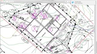
Boundary Survey

Vložit
- čas přidán 28. 04. 2010
- www.ludlowengineers.com
A boundary survey determines the property lines of a parcel of land described in a deed. It will also indicate the extent of any easements or encroachments and may show the limitations imposed on the property by state or local regulations. - Jak na to + styl


Good video. Bought a 1945 house in 2011 where the land was all one piece and they divvied it up to sell off each lot plus some acreage behind the house. After closing and receiving all the papers and then getting a plat map, I started measuring, because I want to know where my boundaries are. Soone I discovered that the lot line went 2 1/2 feet into the garage. About the same time the man that bought the lot with the shop on it discovered the same thing. So we offered to buy the land from his lot that we needed to make a lawful setback on his side and pay for surveying, the land and all closing costs. We paid $40k for the house and lot and refurbed the house with an addition and sold it to our daughter for 197k 4 years later. I worked for $1 dollar an hour I figured. A lot of work bringing an old house up to new code and fixing everything wrong with it.
This was very informative! Thank you for explaining and using examples!
Thanks. I learned so much! I'm just starting a real estate license. I've made thousands of copies of surveys for law firms with my prior business and always thought someday, I'm going to try and figure out what all this means. I now know a lot of it. Thanks again.. Turtle Island, Lake George... and step on it!
Thank you! Very easy to understand your explanation.
Nicely done video!
Fantastic information. Thank you for providing this youtube
I have done boundary survey and location in 46 different states!! I had a robotic survey instrument and also a survey grade GPS unit with a base station. I would calc all my point whether it be the property or ad joiner property corners. Some places were rough and hard to get there. Ive worked in Las Vegas, New York City, San Dieago, Chicago, Dallas, Denver, Atlanta and many other cities. Some times it would be the middle of the woods in BFE in South Carolina. It was everywhere I had to work.
How do you Calc your coners?
i need surveying equipment to buy, I am in Ghana Africa
What's your e mail?
web site?
Wow what a great video! As a paralegal who needs to read surveys, I thank you!
Best explanation ever.
Thank you very much for sharing this video
Wow! This the one and only survey I've seen (in over 30 years of real estate practice) where North was indicated how it was determined with any accuracy. Usually it's just an arrow or half arrow with a notation of "magnetic/date" or "True". I guess now that GPS has taken over, we could hope to see actually correct North Arrows.
You have great speaking voice also informative.
Anyways. This was an EXTREMELY informative video. No cartoons just super FACT filled. Thanks.
Thanks man! Helped alot!
I note that the Covewood Trail is marked as a Bridal Path. Is this another language variance from English as understood in England to English as written in the US? In the UK this would be a bridle way, a right of way over which you may pass and repass at will either on foot or mounted on horse, pony or bicycle, but excluding motorised vehicles of any type. Anything that is 'bridal' relates to the bride at a wedding!
Interesting video nonetheless!
I haven't viewed the video yet, but I wonder what the practice is for setting boundary line stakes when one side of the property is a lake or river.
What happens when someone is on your property boundary and have been for years?
What does “PF” mean on surveyors map
A lot of good information. However, I was hoping that you would explain the boundary line numbers. Seeing a number like: N36'50'21"W What does that mean? It is obvious that 1387.18' stands for 1,387.18 feet. My question about the boundary line number like N36'50'21"W would include is that true north or magnetic north?
Trying to figure this out myself as well. There should be a notation with the language "basis of bearings" to tell you what it means. As for the notation, I think of it as an ordered list of relative instructions: Due North from the named point, and then 36°50'21" deviating from that North bearing over towards the West, would be N36°50"21W. When looking for document file numbers from the Land Map of the parcel itself you may see abbreviations like L/S (Land Survey) and R/S (Record of Survey) which are types of documents that will be filed with the regional government Assessor. I'd like to know from any professional surveyor if you were going to set a missing section corner on the basis of a bearing, then is there some trick to making sure your reference to North is the same as it was when the Record of Survey was made i.e. if it pre-dates the 1980 geoid?
what is Cal ? what unit is it ?
Question: Is it legal for anyone to have a SURVEY done on a piece of property belonging to someone else, without his knowlege ?
@2:35 you point out the 2" angle iron. If you wanted to view that point from google maps how would you find that coordinate? The plan says N51º52'20"E but that's not enough information? I'm trying to use my plot of land to figure out where the properly line begins on google maps. Thanks
gpguy25 You can find that with your iPhone using google maps, very easy! This guy is very boring, and not giving any information I don’t already know!!!
What you listed is a bearing. What you want are coordinates. If you're using Google Earth you probably want lattitude/ longitude.
You likely wont be able to plot an accurate bearing on google as the map may not be at the precise same rotation.
thanks! that was useful!
Thanks for the great video
Im about 28 acres rural country land thick wooded how much and how many stakes thanks
Is is accurate alright. Only real estate agents pronounce it the way it really spells.
do you do a survey for a lot in Florida, tks.
Helped a lot
How much did this one cost?
I haVE A map like this one in the video.
i want to mark this line on my property ... N 58 48' 50" E
can I do that with a cell phone app , or do I always have to find the corners ?
I have a gps and was wondering the same
You can mark up your map in any way you wish - it is your map. lol. But seriously, get a protractor and draw a line relative to the North arrow that is NE58... degrees, etc. Now that is probably totally useless to you. You need an actual point from which to draw that line. Once you determine that, you will have your solution.
I purchased a property with no fence. I'm going to fence the back of the house. I have my survey. And question is as long as I stay inside the boundary then my fence is fine?
You can always share a fence with your neighbors, then the fence would be in the middle of the boundary.
Nicholas Gomez might want to check local codes before installing fence, sometimes it is required to say on your side of line a bit, sometimes its not an issue.
Thank you.
The property we are looking at says 150' of road frontage on the realtor page but we went to the property and between the survey pins we found in the front of the property and going by the surveyers map it is over 429' wouldn't that be the frontage on the gravel road?
This is a typical discrepancy and you would need to investigate further. Either the Realtor transcribed things incorrectly (likely) or a boundary pin was missed or removed (probable). If you are sure the survey is the most recent one, (determined by reading the actual Deed) the survey is deemed to be the governing instrument.
YOu may be looking at an older survey that doesn't show current lot divisions.. Also many realtors are notoriously ignorant and believe anything they are told. They can add and subtract, but trig and geometry - not so much. Look at the Property appraiser aerial and "tax map" which should explain such a huge discrepancy.
I ENJOY this presentation
Why my land is missing 16.5 feet in two sides is that normal??
Does anyone know if you own majority of a pond but the neighbors own a tip of it. Do they have legal access to the entire pond?
That's a question only a qualified attorney can answer. It will depend on State Law.
If the agent or the land owner does not know where can I find out this in case there has been one
you can hire a land surveyor to check it for you
Im looking to buy a piece of land here in my state. I want to put a mobile home on it. How can I tell if a piece of land allows mobile homes on it?
Ask the town's Zoning Administrator. Or read your town's Zoning Ordinance. Most are online now. Usually, mobile homes (aka "manufactured housing") are relegated to only a select area of town, usually colloquially referred to as the "ghetto".
If you are buying property and closing in a title company, requesting a survey is not an option. The title company will require a Title Survey (different than Boundary Survey) because the title company is issuing a Title Policy and they want to make sure the title is no clouded and there are no problems with the property (encroachments, land locked, easement issues,etc.).
Can't you get a warranty title
I have my hands on a plat showing 69 feet of property line until it reaches the next house. I have corner lot. From what point do I begin the measurement from the corner/curb across to the next house?
Hope you got your answer.I have a survey coming up neighbor stole my yard and part of my land complete nightmare….
If there is no monumentation (Granite marker, Iron Pin, Iron Rod, Railway spike, etc) properly marking a bound, you need to get a licensed surveyor to make that determination. As in this example, you take bearing and distance measurements from the monuments in the ground. If the monuments are not there, only a licensed surveyor can put them there (or replace them if they are missing). If two surveyors disagree on the boundary locations, you will then need a attorney to represent you and have a Court decide where that marker needs to be set. Usually, it is easier to sell the property and pass the problem on than to go to Court. Good luck.
Pls as a lay man how can you help learn this job. I'm really interested
Can someone help me out with reading my survey? because from what I'm seeing on mine it's not adding up unless I'm doing it all wrong something isn't making sense about mine compared to this
I have 3.3 acres and that's 143748 square foot with my survey that's not showing that especially with the numbers I'm seeing.
Areas of an irregularly shaped polygons can be difficult to compute because it requires creating a mosaic of known shapes like triangles and rectangles that are easily computed, then adding those individual areas together. Usually on a surveyed plan, the Surveyor has done that calculation for you. If he did it wrong, you would need to have him correct it or have another surveyor correct it.
Thank you for the knowledge
Who maintains the 50 foot ROW?Thx..and are you taxed on it?
In this case, the State. You are taxed on the underlying "fee" - legal speak for the underlying property. So, yes, you get taxed on the land under the road, but others are allowed to use the road in a limited fashion (i.e. to pass and repass with men and equipment, etc.) In addition, you are limited in using the underlying property within the ROW. Each State/locality has different rules. depending on the purpose of the ROW.
I have a question. What do the angles relate to ? Are they compass bearings, or angles from a road? Thank you for sharing your knowledge.
Mary Daley . My opinion is that the angles are compass bearing. I do architectural drawings and on a site plan I have to place the drawing and let true north and project north aligned together for bearing purposes....
They are bearings that relate from a known point to another known point. If you do not have the known point, they will not do you any good. You can convert them to an azimuth ( compass) by subtracting or adding them from 360 depending on the direction ( quadrant) they are going.They are derived from the overall plat of an area.
They are extremely precise compass bearings from a known point.
Not compass bearings. They are derived from the relative horizontal plane angles from each of the points along a specific path from the POB (point of beginning). Usually the path is CW or CCW from the POB. In this example, it appears to be a CW traverse from the POB, heading SW, then NW, then NE, then SE back to the POB. On some sloppy surveys you may need to change NS and EW depending on your course. This represents a 180 degree course correction and should be obvious whether you are going towards or away from the sun or magnetic North on your traverse. I am impressed that the surveyor actually took the time to accurately determine where North is and remained consistent in his traverse bearings. Almost all surveys I have seen and used only throw down a highly inaccurate magnetic North bearing. 20 years ago this was an issue, but nowadays with GPS it s not that big a deal since it does not take a great deal of effort to tie into a proper Geodetic marker on the earth. Although it does not appear this surveyor did that with this survey. So technically you would need another survey to tell you where this parcel is relative to an officially known earth-point. Or, alternatively, call this surveyor up and ask him to complete the job properly.
About how much does a survey cost?
About the cost
Remonumentation Survey?
Which instrument provides these numbers such as N51 52'20'E 100.12' ? I am trying to find where my property ends exactly and I have a similar number but unsure which instrument to use to locate the boundary of the property with this number on my boundery survey.
I'm also trying to find similar information. I think that number is actually a relative location from a specific point on the survey. So if I'm understanding right, you have to know what corner the surveyors start at to know where all the measurements go to. I thought at first it was GPS coords but it's not...
Here's what I found, "those are not lat/longs in the description. Those are bearings and distances. What you have is a metes and bounds description which locates a point, gives bearing and distance to the next point, and so on all the way around and back to the point of beginning (known as a traverse)."
I turned on my GPS some values were close but still 8 feet far off which I was told that's about right for a home GPS so I cannot rely on it to do know precise home boundary. However your answer makes more sense
@@donpablos123 The survey grade instruments needed can take a variety of forms and all are very costly ($4k and up as of 2022). If you use a high accuracy GPS (see Sparkfun Facet L-band for $1.5k) you will need to tie the Lat/Long coordinates to another actual known Earth point. These are called geodetic location markers and are cataloged at (geodesy.noaa.gov/). Because the Earths surface is in constant motion (about 2 cm per year) this is the only way to properly get an absolute fix on where any local survey markers are located. Note that the only person who can officially determine boundary locations are licensed land surveyors. However, if you are looking for survey markers that should be in the ground, then a highly accurate compass (Suunto $300) and a tape measure is all you should need. Take the compass to the POB in this video's example, point it along the bearing stated and pace out the distance indicated and look around. You should be within 10-20 feet of the "Iron Pipe" or "Iron Pin" or whatever the marker is. Then paint it florescent pink and hang some vinyl tape every couple years so you can find it easily the next outing.
Way cool: thank you. I have Homestead Entry Surveys to understand.
Wow #DavidCross is secretly a surveyor!!
really doesnt explain much... bearing to gps ? bearing isnt same as gps is it? not a lot of info or at least what iam lookin for
Watching in 2020
I was told to measure 15 feet from the center of the road is that true I know where my property pin is when i measure from that pin someone else's barn in on our property .I use a measure wheel , How should I do this I live in NY State.
The right of way differs from county to county generally. Some places might have a 15 ft right of way, others may be 25ft
what program do they use to draw this map????
autocad
I think you missed the point Jeff... He was simply stating why people need a survey. I didnt take it as a gaffe on real tors.
Real 'a tor
@@nikkingman More correctly, Real Estate Agent. Not all real Estate Agents (licensed by the State) are Realtors (tm) (a private club). But all Realtors (tm) must be Real Estate Agents. Common misunderstanding. Also the term Realtor(tm) is properly written with the (tm) to acknowledge it is a registered trademark. Private clubs are funny that way.
How large is a lot?
Wish I would of ran into this video before we purchased half an acre😭😭😭
I just bought an acre of land in Az. And now no one knows the bountries
Or coordinates to my property.
@@aztecwarrior7678 This is exactly the reason for the existence of Licensed Land Surveyors.
I
Learning ty ❤
Interesting information but everyone should know this is not the REALTOR®'s job. If you have a concern, you should ask the REALTOR® and that person should direct you to the local municipality or a surveyor, but not to the details of the plat via explanation unless they have expertise in that discipline. Good information though.
So Realtors(tm) are just glorified cheerleaders then?
What Realtors don't tell you, This is because we can be sued and we are not surveyors !
$1500? Try $2700 now in 2021 in Los Angeles county
Torrent system: Title to Land must be surveyed and registered in the Land Office. This type of landed property is called "indefeasible title" meaning the right is guaranteed by the Land Law @ Government. So before paying a land broker, confirmed the locality, the area, the registered proprietor/co-proprietors (share?), special conditions of land (dwelling? agricultural purposes? etc), any encumbrances such as Charge to Bank? Power of Attorney? Caveat?, Debt?(utilities bills, land rent, local council?) and duties involve? stamp duty? legal fees etc. Pay only when a Memo. of tranfer is signed by both parties and request your lawyer to submit and register at the land office as fast as he/she can. Careful, confirm and satisfy yourself that you are dealing with the real proprietor and an efficient law firm.
I own land jointly at Gandevi Taluka of Navsari district bearing Survey No 387, We wish to make three division of land by measuring from government Department.Can u help me to do this.
Nothing
so what you are saying that a sales person is not responsible for what they are selling. No wonder the drug companies train extensively before the let the drug rep out in the field. No sir you are wrong. Don't sell something that you ahve no knowledge off. Remember realtor work under a broker, and there is a strong need to regulate them. Back in the days dr, lawyers were not regulated either.
Holy Cow, Mr. Relator. I didn't see one thing to imply that realtor's are liars. The actual video explained the surveyor's map and how to read it more than anything. The buyer needs to be aware that it is not in the realtor's best interest to recommend a land survey or anything that may impede the sale of the property; such as actual acreage, encroachments, and/or possible boundary disputes. It is the land surveyor's responsibility to report the facts, and the Realtor's to sell the property.
Unless, of course, the Real Estate Agent is working for the buyer.
Great information! However the word "Realtor" does not have an "a" after the "l".
Nice Video..
I am team leader of survey draftsmans and QC also . If you have any work of drafting for my team please reply me asap ❤️ your satisfaction is our priority . 👍🏻
I was assuming you explain how to find lot lines in this mess. you drag on and put me asleep.
This guy is horrible. Never explains bearings or distances along those headings.
wtf is that it is not even readable
Ohio has a 21 yr law if it was yours for that long it is your property 🙌🙏🏽
Says "realtor" weirdly
Working in the property tax division, it is so irritating for the idiot public and real estate agents use TAX MAPS instead of hiring a licensed Land Surveyor. I hear all the time, they are too expensive or some other stupid reason. Tax maps are NOT and NEVER will be survey accurate!!! I wish the public would learn this!!!
Rich C I have a question for you. Is it safe to say that the collection of property tax, from any state property tax division is inaccurate as well! Since "tax maps are "NOT" and "NEVER" will be survey accurate?" Just asking!
@@MU5TANG5 MUSTANG, you are the winner....... Rich is definitely a loser! Any city official who refers to citizens as stupid, and diots deserves a punch... call it a "Fruit" punch.
@@MU5TANG5 You are correct in stating that. So when you get a proper survey, you need to visit the tax assessor and have them adjust your appraisal. Because they work for the State, they will get annoyed and charge you more.
You do realize most tax maps were created by licensed land surveyors? There is a compelling argument that because this is the case, they are liable for any errors since the standard of care does not change simply based on who the client is. Regardless, while what you say is strictly true, tax maps are a great resource to use as a first-pass/preliminary field guide that can provide the interested party a go/no-go assessment of project viability. Imagine if you had to fork over thousands of dollars for each property you have a passing interest in. That is insane!
@@freedomhillbilly348 Thank you for your valuable input.
I thought I would share a few observations:
1) After "watching" your video (frankly listening to it, as the video portion serves no function), I honestly have no clue what information or instruction you're trying to share. There seems to be no purpose to your efforts.
2) It gets confusing at 8:15 "A buyer was selling a piece of ground... where they thought they had approximately 14 1/2 acres to sell" It seems as though a "seller" would have the land to sell and the buyer would be attempting to purchase it... However, you might be on the other side of the equator where things are done differently lol
3) In general, the narrator has a pleasant voice, speaks very well and is easily understood. He should continue working on producing videos. I would recommend starting out by explaining what the viewer can expect to learn from the video... It's also helpful to summarize at the end of the video.
4) You're producing a video, underscore and in bold - it's a video a.k.a. visual broadcast. Try to incorporate and leverage the benefits inherent in video media.
P.S. I was trying to find an explanation of the boundary references e.g. N 50° 34' 18" W. Is everything referenced from the Point Of Beginning (POB)?
I found that the visual was key in illustrating what he was attempting to convey. To answer your question, yes, the Point of Beginning is the POB. That said, because all the other points, bearings and distances have been resolved, you are free to start at any marked point and head in any enumerated bearing. As long as you remain consistent in your course (i.e. clockwise or counter-clockwise) from your start point, you will end up traversing to each marked point and arrive back at your start point.
Western NY Realtor here. All properties I’ve sold have had survey maps in the last 11 years. Lots, acres and homes. Pretty sure it’s mandatory.
This video is not factual for many places. Please see local laws before thinking “your Realtor” is cheating you!
"Western NY". Problem solved. lol.
tepu land mark sarvey
this property is eriely similar to my fathers, but yet not the same,
STOP BLOWING INTO THE MIC. Talk to the side but not right up to it. Were you using a headset, like for gaming? Annoying as hell.
get a pop filter!
contore survey
Contour
(Real-tor not Real-a-tor)
Your mic. Wtf
OMG surveyors CAN and will lie for a land seller!
It's realtor, not relitor. Let's use the language we've all agreed on, shall we? lol
spelling teacher.....
Actually, it's real estate agent. REALTOR® is a term that is trademark owned by NAR and protected by federal law.
I couldn't get through all your "p" sounds.
SURVEY COMMISSIONER JUDGE COURT,CHITTAGONG.BANGLADESH
REALTORS ARE THIEVES AND LIARS. NEVER USE THEM. YOU DON'T NEED THEM.
Clearly you've had some bad experiences. While the majority of Real Estate Agents are just glorified cheerleaders and are as empty headed as any Los Angeles blonde-headed bimbo, it is up to YOU to find a good one that will meet your needs.
@@freedomhillbilly348 They are thieves and liars period. All of them.
Complete waste of TIME!!! No one CARES about your personal experiences. Did Not Provide One iota of Information. Just like to hear yourself ramble and ramble! Politics should be your next career move!