
- 43
- 439 057
Engr Mannan Mushtaq
Saudi Arabia
Registrace 7. 08. 2020
Hi everyone welcome to my CZcams channel. My channel Content are created for Educational, Information and guidance propose for Civil 3D Learners, Technical Engineers, Civil Engineers, Quantity Surveyors, Auto cad Draftsman and surveyors and other professional related to Engineering and construction field.
This channel have no connection with any illegal, Criminal activities or any other unlawful activities.
Email address for any inquiry
mannan.mushtaq2020@gmail.com
#EngrMannanMushtaq
This channel have no connection with any illegal, Criminal activities or any other unlawful activities.
Email address for any inquiry
mannan.mushtaq2020@gmail.com
#EngrMannanMushtaq
How to Change Cross Section Bend Level in Auto Cad Civil 3D
This video is about how to change Cross section bend level in Auto Cad civil 3D
zhlédnutí: 1 763
Video
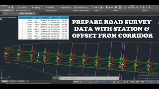

How to Prepare Road Survey data/Level sheet with station and offset from Corridor in Civil 3D
zhlédnutí 7KPřed rokem
This video is about how to prepare Road survey data level sheet with station and offset from corridor in civil 3D

Drainage Channel/Ditch Design & Cut/Fill Quantity Calculation in Civil 3D
zhlédnutí 25KPřed 2 lety
This video is about how to design Drainage channel and cut/fill quantity calculation in civil 3d. #Drainage #Channel #Ditch #Civil3D How to create Feature Line in civil 3D czcams.com/video/5y0RgqU_-B8/video.html How to create Assembly in civil 3D czcams.com/video/9HtC9U-kBNc/video.html How to create Corridor in civil 3D czcams.com/video/b2eMj8Ac9B4/video.html

Civil 3D Design/Grade Profile Creation from External File
zhlédnutí 2,5KPřed 2 lety
This video is about how to create design/grade civil 3d profile from external file. #Civil3D #Design #Profile

Bridge Foundation Concrete Volume Calculation Pile-Pile Cap-Abutment-Pier
zhlédnutí 3,4KPřed 3 lety
This video is about how to calculate bridge foundation concrete quantities. Pile Pile Cap Beam Abutment & Pier Foundation #Bridge #Concrete #Pile #Abutment #Pier

QIWA Registration Saudi Arabia New Labor Law March-2021 How to Register on QIWA Portal Urdu/Hindi
zhlédnutí 37KPřed 3 lety
This video is about how to do registration on QIWA portal in Saudi Arabia Which is Electronic Services provider for Ministry of human recourses and social development (MHRSD) #Qiwaregistration #QIWA #SaudiArabia

Subassembly Shape Creation From Polyline in Civil 3D
zhlédnutí 6KPřed 3 lety
This video is about how to create subassembly shape from polyline in civil 3D #RoadAssembly #Autocadcivil3D

How to Create Cut/Fill (Earth Work) Construction Production Plan in Civil 3D
zhlédnutí 3,6KPřed 3 lety
This video is about how to create cut/fill Construction Production Plan in Civil 3D. #AutoCadCivil3D #MannanMushtak #Productionplan

How to show cut/fill Material in Cross section-Material List-Compute Material in Civil 3D
zhlédnutí 10KPřed 3 lety
This video is about how to show earthwork material in cross section and how to compute material from material list in civil 3D #AutocadCivil3d #MannanMushtaq
Interchange Complete CUT/FILL Volume Calculation in Civil 3D Last Lesson
zhlédnutí 534Před 3 lety
This video is about to Tin and Volume surface creation and Interchange complete cutting and filling Volume calculation. #AutocadCivil3D #Interchangecut/fillvolume
Interchange Earthwork QTY Calculation Lesson-3 Ramp-Loop-Road Corridor Creation in Civil 3D
zhlédnutí 1,3KPřed 3 lety
This video is about how to create corridor in civil 3D for interchange Ramp Loop and Road. #InterchangeCorridor #AutocadCivil3D Here is the link how to create road assembly www.youtube.com/watch?v=9HtC9... Here is the link how to create Corridor www.youtube.com/watch?v=b2eMj...
How To Take Levels from Different Surfaces at Same Points in Civil 3D & Export To Excel Sheet
zhlédnutí 5KPřed 3 lety
This video is about How to take different surface levels at same coordinate in civil 3D Here is the link to learn how to export points from civil 3D to Excel czcams.com/video/OskGMVkEjUA/video.html #SurfacePointLevels #AutocadCivil3D
Interchange Earthwork QTY Calculation Lesson-2 Civil 3D Profile Creation from Autocad 2D Profile Dwg
zhlédnutí 525Před 3 lety
This video is about how to create Civil 3d Profile for Ramp Loops Roads as per auto cad 2d Profile given in drawing. Here is the Link for how to Create Surface Profile in civil 3D. czcams.com/video/VB7fwiADX_Y/video.html Here is the Link for how to create Feature Line In Civil 3D czcams.com/video/5y0RgqU_-B8/video.html Here is the Link for How to create Road Assembly in Civil 3D czcams.com/vide...
How Consultant Surveyor Check & Approved survey level at site with Contractor Surveyor
zhlédnutí 560Před 3 lety
This video is about how survey team check and verify survey level at site with GPS as per approved drawing. #SurveyLevel #MannanMushtak
Interchange Earthwork QTY Calculation Lesson-1 Superelevation Adjustment in RAMP Alignment Civil 3D
zhlédnutí 1,2KPřed 3 lety
This is lesson-1 to calculate complete earthwork quantity for a highway interchange and this video will show how to insert superelevation to a ramp alignment according to profile and cross section in civil 3d. Here is the Link for this Interchange Civil 3D drawing You can download this drawing from Link. we.tl/t-m7b1KGWYcJ and here is the link for my other video how to create road assembly czca...
Plot size 25x50-5 Marla House 2D Floor Plan Using Sketchup Part-2
zhlédnutí 162Před 3 lety
Plot size 25x50-5 Marla House 2D Floor Plan Using Sketchup Part-2
Surface Elevation Table Creation with area and Cut/Fill Volume in Civil 3D
zhlédnutí 11KPřed 3 lety
Surface Elevation Table Creation with area and Cut/Fill Volume in Civil 3D
Plot size 25x50-5 Marla House 2D Floor Plan Using Sketchup Part-1
zhlédnutí 281Před 3 lety
Plot size 25x50-5 Marla House 2D Floor Plan Using Sketchup Part-1
Point creation from surface on Grid with Levels in civil 3D
zhlédnutí 21KPřed 3 lety
Point creation from surface on Grid with Levels in civil 3D
How to Calculate Level for any Concrete Structure
zhlédnutí 767Před 3 lety
How to Calculate Level for any Concrete Structure
Sketchup Building 3D Modeling Program Introduction in Urdu/Hindi
zhlédnutí 160Před 3 lety
Sketchup Building 3D Modeling Program Introduction in Urdu/Hindi
Export Alignment Setting Out data from civil 3D to Excel
zhlédnutí 20KPřed 3 lety
Export Alignment Setting Out data from civil 3D to Excel
How to Create Road Surface Profile In Civil 3D
zhlédnutí 12KPřed 3 lety
How to Create Road Surface Profile In Civil 3D
Trick to Create Survey data Fast with Coordinate and Levels in Civil 3D & Export to Excel
zhlédnutí 8KPřed 3 lety
Trick to Create Survey data Fast with Coordinate and Levels in Civil 3D & Export to Excel
How To Create Road Cross Section with Cut/Fill Quantity In Civil 3D
zhlédnutí 22KPřed 3 lety
How To Create Road Cross Section with Cut/Fill Quantity In Civil 3D
How to create Sample Line In Civil 3D for Roads
zhlédnutí 4,7KPřed 3 lety
How to create Sample Line In Civil 3D for Roads
How to Prepare Bill Of Quantity (BOQ) in Excel for any New Construction Project/Bidding/Tender
zhlédnutí 6KPřed 3 lety
How to Prepare Bill Of Quantity (BOQ) in Excel for any New Construction Project/Bidding/Tender
How To Create Road Corridor/Set Corridor Target and Surface Creation from corridor in Civil 3D
zhlédnutí 2KPřed 3 lety
How To Create Road Corridor/Set Corridor Target and Surface Creation from corridor in Civil 3D
How to Create Grading/Side Slope from Feature Line in Civil 3D
zhlédnutí 26KPřed 3 lety
How to Create Grading/Side Slope from Feature Line in Civil 3D
❤
Plz manan sahb ham profile ma poray design level ko cm ye 30cm kasy up ya down kr sktay hai.poray design level ko
Ye to apny pgl k level liye, agar hamen pav1, subbase. Subgrade k level chaye hn to wo kesy create krengy... Kia hm markepoint lga skty hn pav1 r subbase pe...ya per excle m thickness minuse kr k sheet bna len??
THANK YOU SIR CAN YOU SHARE SUPER STRUCTURE CALCULATIONS ALSO SIR
very informative video for all of engneer surveyor.
salam eng manan kindly ham kasy aik surface ko banaky apni marzi kay grading slop dangay.yani ham chatay hai kh es area ka pani es taraf ho
plz surface par aik complet video banao
subbasse will not superelevate
Thnx brother please share me link of creating alignment with curves on surface. After that I’ll be able to export the alignment SO Csv. Thnx
Bahasa indonesia ya...
I cant see bands like yours. Please help
Eagle point road calc per ak typical bnafay
Sir civil 3d ko hum kese download kese kare
A.o.A jis jagah kharay hen us ka zone kesy check ho ga wo ap nay nahi bataya sir
Hi Mannan , Any online session coming up?
Bro i have one doubt
Very good Allah bless you
MashAllah sir
Sir plz Sath Sath options ka nme btaya kryn k kis kis ko select krny krna hai
AOA sir i strart Civil3D from your channel . Kindly sir provide easting northing and elevation data for road design for practice
Sir, ek baat bataiye mere pass post or pre dono data hai or area bhai hai zik Zak type ka or wo dredging channel hai uska cross section kaisa banaye with coridor
G waseem sir kindy mujay ye batay kya civil 3d ma surface par jo spot level layty hai kya wo points ma converts hoskaty hai .ya wahi spot level on surface excell ma lay kay ja sktay hai.
Mr. Why is that when we do the LHS edge11:55 we take the RHS EDGE number to minus the 0.09225? And why not take the CL number to minus it?
Hello, is there an option to get area to show as one of the columns if it does not do so automatically?
Good Knowledge
Thank you for this important info
Hiy Dear How are you , Thanks for all your presentation /lessen/ . if it is possible please attach her for us the steps of doing that in PDF words b/c it is dificalt to understand your words when you speak .
thank you sir
Salam. Eng manan. Agar maray sat kisi area kaley disigner nay FGL dey ho. Or ngl b ho to mujay kasy pata chalga kh ma FGL tak ponch chuka ho. Or ye layer kinti cm ki hogi jasy ap nay video ma kaha ye maray 2nd layer kay level hogi.
Aisa to nhi hai kh ham pahaly ngl surface banay per fgl ka dono ko excel ma layker jay udar FGL kay sat uska mawazena karay filling ka. Or layer level nekaly or 1 st layer 2nd layer ky level us ma banaker civil 3d ma lay or per uska surface banay.
SIR EARTHEN DAM WITH SPILLWAY K SATE COMPLETE VIDEO BNASAKTY
Please send me soft copy
Good work
Sir ye konsa software h
Sir ye konsa software h
Please make your video in English for easy understanding, thanks
How to show culvert and causeway Crossing in profile..
4:35 sir I didn't get report in miscellaneous utilities, please help
Bhai jis capni main kam karte hai ye capni kahi or capni main to nahi bej degi na jis capni main aaye hai usi capni ka vija je aaye hai Esa koi koi msla to nahi hai na bhai
Jeddah ja Kia zone ha
Excellent sir, Very much useful Thank you
Vay sab, o level kahase aia tora batao ditels sir.
Bai main ni by description cl se station malom karna hai plz
I can't find the zone list 45R in autocad to export in google earth. It all starts .... With uTM zone N and S only.
Sir send the drawing with estimate to my email id
Assalaomaliakom. How to update crossections and volume tables if we make some changes in our profile to minimize the variation in our cut fill volumes if they are already created.
Your videos are always very short with very highly information… 😊
Nice video
Ye autocad me kaise hota hai?
Appreciated
Sir Thank you very much for this. It helped me in my exam in school. If you can send the template you would do me a big favor. Have a nice day sir!! Thank you very much once again.